MAPS OF HISTORY · The American Civil War · ALL CHAPTERS · CHAPTER 1
CHAPTER 1 · 1850–1860 · JAN 1861
A House Dividing
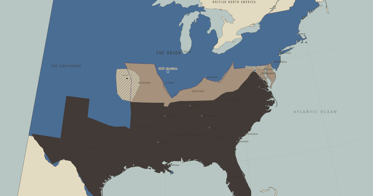
The map above is the world of APR 1861 — Sumter — the house divides.
BRIEF EXPLANATION — THE ESSENTIAL ARGUMENT
The crisis that produced the Civil War was a fight over slavery, and the reason it could not be compromised away is that slavery was three things at once for the South: a system of forced labor, an enormous store of wealth, and the basis of Southern political power. By 1860 roughly four million enslaved people produced the cotton that made up a majority of American exports, and by the slaveholders’ own reckoning they were the single largest form of property in the country. A threat to slavery was therefore a threat to Southern wealth, status, and political control together, which is what made compromise so hard to reach.
The contest settled on the western territories because expansion would decide slavery’s future. If the institution could spread into new states, its market value and its votes in Congress would grow; if it were fenced into the existing South, slaveholders feared a slow decline, and that is why a distant territory like Kansas could feel decisive. Across the 1850s the compromises meant to contain the quarrel collapsed one by one. Kansas–Nebraska reopened the territorial question, Dred Scott denied Congress the power to exclude slavery, and John Brown’s raid deepened Southern fear of Northern violence. Lincoln’s election in 1860 then proved that a coalition opposed to slavery’s expansion could win the presidency without a single Southern vote, and the Deep South read that result as the end of its national power.
GUIDED EXPLANATION
The politics of the 1850s become intelligible once we follow the money beneath them. Enslaved labor made the cotton South one of the wealthiest agricultural regions on earth, and because enslaved people were bought and sold as property, that wealth was also a form of capital that planters, lenders, and states all counted on. This tied plantation profit, credit, and the market value of human beings to a single question, which was whether slavery would keep expanding. Slaveholders reasoned that an institution confined to its existing borders would lose political weight and market value over time, so they treated any limit on expansion as the beginning of a long decline. That is the reason a territory like Kansas, where cotton was not yet grown, could feel like a matter of survival.
For a generation the Union had held together by preserving a rough balance between slave and free states, but westward settlement made that balance impossible to keep. Each new territory reopened the question, and each answer narrowed the room for the next bargain. Kansas–Nebraska let settlers vote slavery up or down and turned Kansas into an armed struggle around Lawrence. Dred Scott ruled that Congress could bar slavery from no territory and that Black Americans held no rights the courts were bound to respect. John Brown’s raid on Harpers Ferry then convinced many white Southerners that the North meant to end slavery by force. Compromise had worked while both sections could still win something, yet by 1860 each decision had stripped away another rule that both had once accepted.
The dashed sectional line on the map records more than two economies, because it also marks a shift in political power that the Constitution could no longer absorb. Population growth in the free states made it possible to elect a president with Northern votes alone, and in 1860 Lincoln did exactly that, carrying every free state and losing every slave state. He promised only to halt slavery’s spread, yet Southern leaders saw clearly that a governing majority now existed that needed nothing from them. Their choice was to accept permanent minority status inside the Union or to leave it, and secession was in large part a refusal to accept the verdict of an election. Enslaved people shaped the crisis as well, through escape, resistance, and the testimony that fed abolitionism, even though they had no vote in the conventions deciding their future. The deepest point is that the conflict was structural: the system was being asked to govern both slavery and an expanding free-state majority at once, a task no compromise could perform indefinitely.
DEEP EXPLANATION — EVIDENCE & INTERPRETATION
Why expansion protected existing slavery
Slavery’s westward spread did more than open new plantations, because it also propped up the value of slavery where it already existed. Expansion sustained demand for enslaved people sold from the Upper South, it added slave-state votes in Congress, and it reassured lenders that human property would keep its price. Understanding this mechanism explains why politicians treated Kansas, a place where cotton was not central, as a question of survival. Historians disagree about how quickly a contained slavery would have weakened; some stress its profitability and adaptability, others its dependence on fresh land and on political power. The evidence does not show that slavery was about to collapse on its own. It shows why slaveholders read containment as a mortal threat, since a policy could leave slavery legally untouched in 1860 while changing the expectations that governed prices, migration, and finally secession.
Cause, argument, and mechanism
The states that seceded left records that let us separate the cause of the war from the language used to justify it. Mississippi called slavery its greatest material interest, and South Carolina dwelt on Northern resistance to returning fugitives. “States’ rights” supplied the constitutional argument, yet the same slave states demanded vigorous federal power when it protected slavery, as they did with the Fugitive Slave Act. Economics was not a rival explanation, because the wealth in question came from enslaved labor and ownership. None of this means that every Confederate soldier described his motive in identical terms, or that disputes over tariffs and parties were imaginary. It means the decision of state conventions to leave the Union is best explained by a perceived threat to slavery. Keeping these levels of explanation apart prevents a false choice: slavery was the institution at stake, economics measured its power, and constitutional theory framed the defense.
New here? Chapters 1–2 of every atlas are free to sample, and the WW2 atlas is free in full. One membership opens all thirteen — the Cartographer’s Circle.
THE SITES
ON THIS DAY
WHY IT HAPPENED
Slavery as capital, not merely labor. Emancipation somewhere threatened property values everywhere: an enslaved person in Virginia was worth more because Mississippi and the territories were open markets. That is why the South fought over distant Kansas. Closing the frontier didn’t just limit slavery, it started the clock on its financial collapse. Follow the money and the politics of 1850–60 stop looking irrational.
Two economies, two civilizations. The free states built factories, railroads, public schools and cities of immigrants. The South built the world’s most profitable plantation economy on bound labor. Each section believed the other was betraying the Founders. The tariff, homesteads, railroads. Every national question became a proxy for the one question underneath.
The machinery of compromise breaks. Compromise had worked when both sections could win something. Kansas–Nebraska destroyed the one fixed rule (the 36°30′ line). Dred Scott destroyed the possibility of any new rule. And the caning of Senator Sumner on the Senate floor (1856) showed that even the forum itself was failing. Institutions do not usually die at once. They die rule by rule.
The sectional math of 1860. Free-state population had grown until it could elect a president alone. Lincoln carried every northern state and lost every slave state. The first purely sectional victory in American history. The South’s choice was now to live as a permanent political minority inside the Union, or to leave it. Secession was, among other things, a refusal to lose an election.
THE TURN
6 November 1860 — the election. Nothing in Lincoln’s platform freed a single enslaved person. It barred slavery only from the territories. But the South read the result correctly: an anti-slavery majority now existed that needed no Southern votes, ever again. Within six weeks South Carolina left. The hinge is not what Lincoln intended to do. It is what his election proved could be done.
WHAT IT CHANGED
Secession begins in the Deep South. South Carolina, then the six cotton states, leave between December and February. Before Lincoln even takes office. Watch which states move first: the deeper the investment in slavery, the faster the exit.
The upper South waits. Virginia, Tennessee, North Carolina and Arkansas vote secession down in early 1861. They hold the men, the food and the factories the Confederacy will need. What tips them is not the election but the choice of April. See the next chapter’s sequence carefully.
Both sides inherit a myth. The North goes to war believing a small planter clique has hijacked the Southern masses. The South believes Yankee shopkeepers won’t fight. Both armies at Bull Run will be composed largely of men certain the other side will run.
FIELD QUESTION — Was the Civil War “about” slavery, states’ rights, or economics — and is that even a well-formed question?
Read the seceding states’ own declarations: South Carolina, Mississippi, Georgia and Texas each name the threat to slavery as the cause, in the first paragraphs. “States’ rights” was the constitutional argument for protecting it (the same states demanded federal power when it served slavery. The Fugitive Slave Act). And the economics were the economics OF slavery: four billion dollars of human property. So the honest formulation is: slavery was the cause. States’ rights was the legal theory. Economics was the mechanism. Distinguishing a cause from its instruments is the transferable skill. Most historical “debates” dissolve when you make that separation.
AN INTERESTING FACT
Harriet Beecher Stowe’s Uncle Tom’s Cabin (1852) sold some 300,000 American copies in its first year — no novel had done anything like it — and stage versions put Eliza’s flight across the ice in front of audiences who would never read a page of abolitionist argument. The beloved scene of Lincoln greeting Stowe as “the little woman who wrote the book that started this great war” is almost certainly embroidery: it surfaces only decades later in family tradition, with no contemporary record. The book needs no legend — its measurable work was making millions of Northerners feel slavery as a story about mothers and children rather than a constitutional abstraction, which is exactly the ground the compromises of the 1850s could not survive on.
THE DISPATCH
One short letter when a new atlas opens — and the printable study guide for The American Civil War is yours now, free.
NO TRACKING · YOUR ADDRESS IS USED FOR THE DISPATCH AND NOTHING ELSE · UNSUBSCRIBE ANYTIME