MAPS OF HISTORY · The American Civil War · ALL CHAPTERS · CHAPTER 4
CHAPTER 4 · NOV 1861–JUN 1862 · APR 1862
The Anaconda and the Rivers
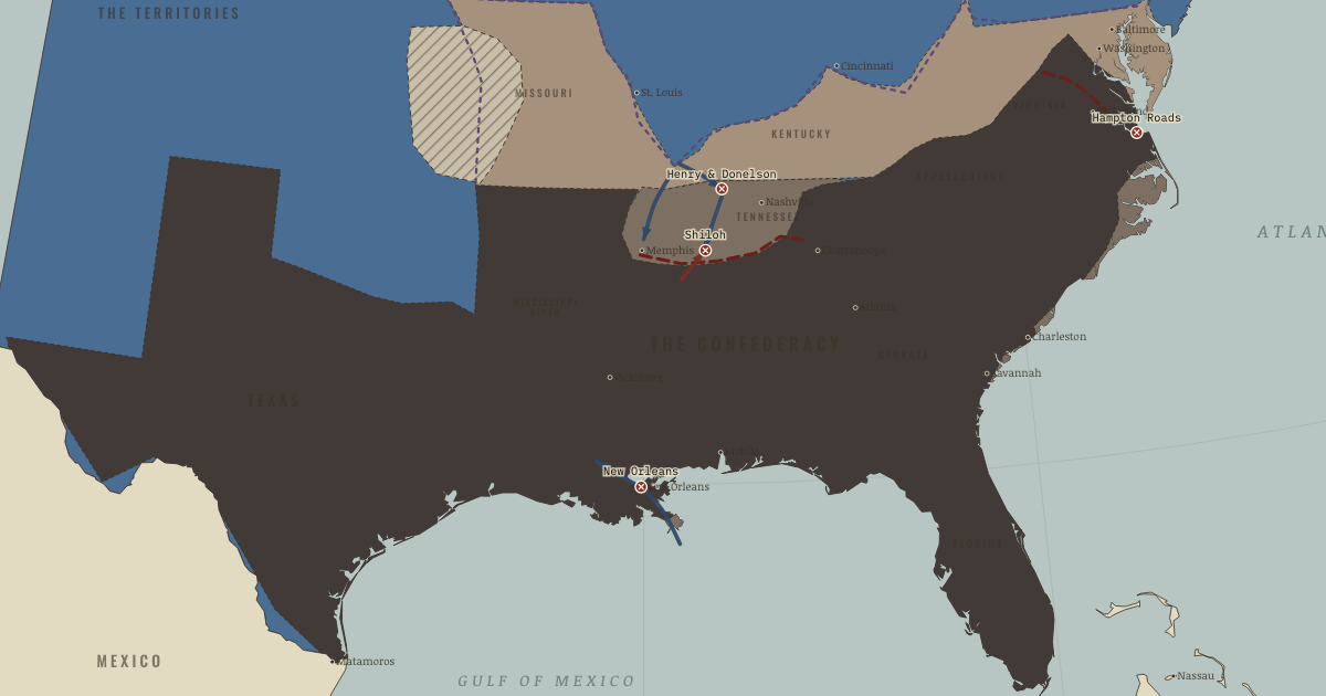
The map above is the world of JUN 1862 — New Orleans and Memphis fall.
BRIEF EXPLANATION — THE ESSENTIAL ARGUMENT
The Union’s winning strategy in the West was a slow one, and understanding why it worked corrects the ridicule it first drew. Critics mocked General Winfield Scott’s “Anaconda Plan” for proposing to blockade the coast and seize the Mississippi rather than settle the war in a single great battle. Its logic was economic: a blockade need not stop every ship if it can raise the cost of everything the South imports until scarcity does the work of an army. Union naval power grew year by year, and the coastal bases it seized also created places where enslaved people could escape and force decisions the government had not yet made.
The rivers gave that strategy its cutting edge, because in a region with few good roads the rivers were the roads, and they ran the wrong way for the defense, north into the Confederacy’s vitals. Gunboats and Grant’s troops broke Forts Henry and Donelson in early 1862, opened Tennessee, and took Nashville, while Farragut’s fleet captured New Orleans from the sea. The near-disaster at Shiloh warned that prying open the Confederate interior would be terribly costly, yet by June 1862 Union control reached deep into the Southern heartland.
GUIDED EXPLANATION
A blockade works through arithmetic rather than drama, which is why its effects were easy to underestimate at the time. It did not need to stop every ship, only to raise freight, insurance, delay, and loss until fewer useful supplies arrived at a far higher price. The growth of the Union navy from a few dozen ships to hundreds made that pressure stronger each year. Occupying the coast produced a second consequence its planners had not fully intended, because at places such as Port Royal enslaved people escaped to the fleet and forced commanders to decide whether federal forces would return human beings to their claimants or treat them as free.
Rivers were the main transport corridors of the interior, and controlling them let the Union carry its industrial weight inland. In February 1862 gunboats and Grant’s troops took Forts Henry and Donelson, opening the Tennessee and Cumberland rivers and forcing the fall of Nashville, the first Confederate state capital lost. At Shiloh that April a Confederate surprise attack nearly reversed the advance, but Union reinforcement held the field after roughly 23,700 casualties. Farragut’s fleet then ran the forts below New Orleans and captured the Confederacy’s largest city and financial center. The map shows two river corridors closing toward Vicksburg, and the combination of geography with industrial shipbuilding is what made that possible.
The grey-tan coastal and river zones on the map show control spreading through connected systems rather than through one dramatic breakthrough. Hatteras and Port Royal gave the navy repair and supply bases, while ironclad gunboats protected movement past forts and let armies carry heavy stores far inland. At Donelson, Grant’s demand for unconditional surrender removed a whole Confederate army and exposed Nashville, and Shiloh then revealed the price of holding such an opening against counterattack. New Orleans mattered as much for finance and trade as for territory, since losing the greatest Southern port crippled the cotton economy and left Vicksburg as the last barrier between Union forces on the upper and lower river. None of this ended blockade running or Confederate resistance. It steadily reduced the routes, resources, and choices available to Richmond, while opening new ground on which enslaved people acted for their own freedom.
DEEP EXPLANATION — EVIDENCE & INTERPRETATION
A blockade as a statistical weapon
Critics at the time pointed to successful runners as proof that the blockade had failed, but that measures the wrong thing. Fast steamers did slip through, especially early in the war, yet they carried compact, expensive cargo rather than the bulk trade of peacetime. Each added patrol increased uncertainty, insurance, and the time a ship spent at risk. Cotton exports collapsed, while imported rifles, medicine, machinery, and salt all demanded scarce foreign exchange. Historians debate how much of the Confederacy’s deprivation came from the blockade rather than from wrecked railroads, its own policies, and Union occupation, and the honest answer is that these causes interacted. A runner reaching Wilmington still needed inland transport, and cotton reaching Nassau did not automatically become usable credit. The decisive mechanism was cumulative friction across the whole supply system, not a coastline sealed on any single night.
Why rivers multiplied Union power
The Tennessee, Cumberland, and Mississippi flowed into the Confederacy and bypassed its weak network of roads, which let steam transport carry artillery, food, and reinforcements farther and faster than any wagon train. Northern yards also converted and built armored gunboats at a rate the South could not match. None of this made victory automatic, since forts, low water, mines, disease, and divided commands repeatedly slowed operations. Grant’s contribution was a willingness to exploit openings before Confederate departments could close them, so that at Donelson he turned a geographic breach into a mass surrender, and after the shock of Shiloh he stayed and counterattacked instead of retreating. The larger lesson is not that technology wins wars, because a gunboat without infantry could pass a fort but not hold a town, and an army without river supply could not remain deep inland. Technology mattered because manufacturing, waterways, and commanders together formed a working system.
New here? Chapters 1–2 of every atlas are free to sample, and the WW2 atlas is free in full. One membership opens all thirteen — the Cartographer’s Circle.
THE SITES
ON THIS DAY
WHY IT HAPPENED
Geography as strategy. The Tennessee and Cumberland rivers pierce the Confederate defensive line like open gates. Navigable highways leading south, immune to burned bridges and mud. Union industry converted river steamers into ironclad gunboats within months. The Confederacy, with a tenth of the shipbuilding, could not answer. The West was not won by genius first. It was won by water plus foundries.
The blockade’s slow arithmetic. A blockade never “works” on any given day. Runners beat it constantly (five in six got through in 1861, still one in two by 1864). It works on the ledger: by 1863 a barrel of flour that cost the runner $8 in Nassau sold for ten times that in Charleston, and the Confederacy paid for imports in cotton it could barely ship. Strangulation is a statistical weapon. Judge it by price indices, not by captures.
Grant emerges. A failed farmer and firewood-seller, restored to command months earlier, Grant possessed the war’s rarest quality: he acted. Henry and Donelson were seized in the seam between two Confederate departments before anyone approved the plan properly. His superiors spent 1862 trying to shelve him. Lincoln reportedly answered, “I can’t spare this man. He fights.”
Ironclads make the blockade possible. At Hampton Roads (see the marker) the CSS Virginia proved wooden fleets helpless. And the Monitor, arriving that same night by absurd luck, proved the answer had already been built. Union industry then out-built the South in ironclads twenty to one. A technological revolution favors whoever can manufacture it at scale, not whoever springs it first.
THE TURN
Shiloh, 6–7 April 1862. Albert Sidney Johnston’s dawn attack was the Confederacy’s one real chance to destroy a Union army in the West and re-lock the river gates. It died with him in the peach orchard on the first afternoon. But the deeper hinge is in the casualty lists. Nearly 24,000. Which announced the war’s true price to both publics. Grant: “I gave up all idea of saving the Union except by complete conquest.” The romantic war died at Shiloh. The modern one begins there.
WHAT IT CHANGED
The Confederate heartland starts to bleed. With Nashville and Memphis fall the South’s iron, gunpowder mills, and its most productive farm belt. Watch the grey-tan wedge in Tennessee never shrink again. Confederate armies in the West will spend three years trying to take back what ten days in February lost.
New Orleans: the door closes from the sea. The South’s banking capital, largest port and largest city falls without a land battle. And with it any hope of financing the war on cotton exports at scale. The lower river’s grey-tan band on your map now needs only Vicksburg to meet the northern one.
Contraband: emancipation from below. Wherever the coils touch. The sea islands, the river towns. Enslaved people free themselves by walking to the army, forcing a policy the government hasn’t made yet. Union officers improvise the label “contraband of war” to avoid returning them. The war is already deciding the slavery question in practice. Chapter 6 is politics catching up.
FIELD QUESTION — The Anaconda Plan was ridiculed in 1861 and essentially followed thereafter. Why do slow strategies get adopted only after fast ones fail?
Because publics, editors and politicians pay the costs of slowness immediately (taxes, casualty lists with nothing to show, elections) while its benefits are statistical and deferred. Falling Southern imports never made a headline the way Bull Run did. Democracies especially must buy time for attrition with visible victories, which is partly what the river campaigns were: the anaconda with drama attached. Notice the pattern’s recurrence. Blockades, sanctions, containment. The slow strategy is usually announced as a complement to decisive battle and quietly becomes the main effort once decisive battle disappoints. Scott was not overruled. He was pre-validated and had to wait for the war to admit it.
AN INTERESTING FACT
Before dawn on 13 May 1862, Robert Smalls — a 23-year-old enslaved harbor pilot — eased the Confederate transport Planter away from its Charleston wharf while its officers slept ashore, stopped at a nearby wharf for his wife and children, put on the captain’s straw hat, gave the correct whistle signals to pass Fort Sumter’s guns, and handed the ship to the Union blockade. His knowledge of Charleston’s defenses went straight to the fleet, and Congress voted the party prize money. Smalls ended the war a captain — the first Black man to command a vessel in United States service — and ended his career as a five-term congressman, having bought the Beaufort house in which he had been enslaved.
THE DISPATCH
One short letter when a new atlas opens — and the printable study guide for The American Civil War is yours now, free.
NO TRACKING · YOUR ADDRESS IS USED FOR THE DISPATCH AND NOTHING ELSE · UNSUBSCRIBE ANYTIME