MAPS OF HISTORY · The Age of Revolutions · ALL CHAPTERS · CHAPTER 7
CHAPTER 7 · 1807–1812 · JUN 1810
The Empire and Its Cracks
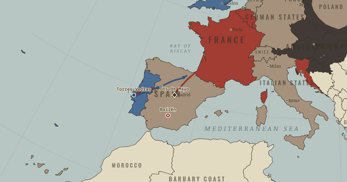
The map above is the world of JUN 1810 — The Grand Empire.
BRIEF EXPLANATION — THE ESSENTIAL ARGUMENT
The Continental System tried to weaken Britain by excluding its trade from Europe. Because the blockade worked only if every coast complied, Portugal’s refusal drew French troops through Spain. Napoleon then replaced Spain’s Bourbon king with his brother, turning an allied transit into an illegitimate occupation.
Spanish juntas, guerrillas and regular armies continued after battlefield defeats. Britain supplied Wellington by sea from Portugal, while insurgents disrupted French movement and intelligence. Together they pinned hundreds of thousands of imperial troops. Spain’s Cádiz constitution also carried liberal sovereignty into both Europe and Spanish America, even as Spaniards fought for an absolutist king.
GUIDED EXPLANATION
Napoleon could not invade Britain after Trafalgar, so he tried instead to close continental markets to British goods. Portugal refused to comply, so French troops crossed Spain in 1807, and Napoleon then forced the Spanish royal family to abdicate and installed his brother Joseph Bonaparte. Madrid rose on 2 May 1808 and was answered with severe reprisals. Local juntas, or emergency councils, then claimed authority in the absent king’s name.
The first crack showed at Bailén in July 1808, when an entire French corps surrendered. The defeat showed that imperial armies could be beaten, although Napoleon later retook Madrid. The war then became harder to finish. Guerrillas attacked couriers, foragers and isolated units; regular Spanish armies rebuilt after losses; Britain used Portugal and the Royal Navy as a secure base. Wellington’s Lines of Torres Vedras protected Lisbon and forced Masséna to retreat after supplies failed. No element worked alone. Insurgents could not remove major garrisons, and Britain could not control the countryside by itself. Together they forced France to disperse troops and fight continuously. Meanwhile, Cádiz’s 1812 constitution declared national sovereignty, giving later liberals a program that Ferdinand VII would reject.
The British arrows run from a protected Portuguese coast into a Spain that French armies could occupy but never pacify. Because Britain controlled the sea, Wellington could keep his troops supplied and wait behind the Lines of Torres Vedras, while French armies had to forage across the country and guard long roads. Concentrating against Wellington uncovered those roads to the guerrillas, and dispersing to protect the roads left the field army too weak to face him — the trap from which the occupation never escaped. The same crisis crossed the Atlantic in political form, because with Spain’s legitimate monarch captive and juntas claiming sovereignty at home, American cities could form juntas of their own on exactly the same legal argument.
DEEP EXPLANATION — EVIDENCE & INTERPRETATION
A blockade that demanded occupation
The Continental System had a coherent aim: reduce British exports, credit and customs revenue when naval invasion was impossible. Its design contained a trap. Britain could redirect trade and use smuggling routes, while continental consumers and producers bore shortages and lost markets. Every open port weakened enforcement, so Napoleon treated allies’ commercial decisions as security threats. Portugal led to Spain; Russian withdrawal from the system helped lead to 1812. The pattern is policy overreach through completeness: a tool works only if universal, and universality requires coercion that creates new enemies. Economic pressure did hurt Britain during crisis years, but the occupations needed to maintain it cost France more than imperfect compliance cost London. The map records the result. Explanation must also keep institutions, material pressure and political choice visible, because none of those forces worked alone.
Why the Iberian combination worked
Guerrilla warfare alone did not defeat Napoleon. Insurgents gathered intelligence, punished collaborators and made roads unsafe, but they struggled against fortified positions and concentrated troops. Wellington’s army alone also depended on Portuguese reform, local information and naval supply. Their interaction was decisive. French units dispersed to protect communications became vulnerable to guerrillas; concentration against Wellington exposed territory behind them. The Royal Navy gave the coalition a supply base France could not close. This is an asymmetric alliance: different partners contribute unlike capabilities that cover one another’s weakness. French military superiority remained real, but its preferred victory condition — destroying a principal army and compelling a central government to negotiate — no longer ended the war. That distinction prevents a dramatic moment from becoming a single-cause story. Revolutionary outcomes emerged through interacting interests, constraints and decisions over time.
New here? Chapters 1–2 of every atlas are free to sample, and the WW2 atlas is free in full. One membership opens all thirteen — the Cartographer’s Circle.
THE SITES
ON THIS DAY
WHY IT HAPPENED
Economic war without an exit. The Continental System hurt Britain (exports slumped, 1808 and 1811-12 were crisis years) but hurt the continent more — and made smuggling a patriotic industry from Lisbon to Riga. Its fatal property: it worked only if total, so every leak (Portugal, the Papal states, eventually Russia) demanded another occupation. A weapon that obliges you to conquer your own allies is pointed at yourself.
Bayonne: legitimacy fumbled. In Italy or the Rhineland, French rule replaced foreign or feudal rulers and could pose as liberation. In Spain, Napoleon stole the crown of an intact, pious, proud nation by trickery at a conference table. The regime he installed was born illegitimate to every social class at once — and no battlefield victory converts illegitimacy into consent. He later called the Spanish affair the knot that strangled him.
Insurgency plus sea power. Neither alone sufficed: guerrillas couldn’t take fortresses, Wellington couldn’t hold Spain against 250,000 men. Together — insurgents denying the French their intelligence and forage, the navy feeding Lisbon and Cádiz indefinitely — they created a war the Empire could neither win nor afford to leave. It is the age’s textbook on asymmetric alliance, still on the syllabus.
THE TURN
Bailén, 19 July 1808. Eighteen thousand imperial troops — admittedly second-line — surrender to Spanish regulars and levies in the Andalusian heat. Materially recoverable; symbolically fatal: the first capitulation of a Napoleonic army in the open field, gazetted in every capital in Europe. Austria began rearming within weeks (the 1809 war), and every conquered people recalibrated what was possible. Aura is a military asset with a single failure mode — Bailén was the crack, and Napoleon had to pour ever more real force in to cover what reputation had carried before.
WHAT IT CHANGED
The veteran drain. Iberia became the Empire’s permanent second front: the men and horses lost there were precisely the professionals missing from the 1812 army, which had to be filled with allied conscripts of doubtful loyalty. Chapter 8’s catastrophe is partly a Spanish invoice.
Nationalism changes sides. Spain proved that the French formula — a people fighting as a nation — worked against France. Prussia’s reformers (Stein, Scharnhorst) rebuilt their state and army on the lesson; the wars of 1813 will be fought by nations, not dynasties, on both sides. The Revolution’s deepest export defeats its exporter.
Cádiz writes the liberal script. The 1812 Constitution — sovereignty of the nation, but a Catholic monarchy — becomes the template for Mediterranean and Latin American liberalism for thirty years; “liberal” itself enters the world’s vocabulary as a Spanish word. When Ferdinand returns and tears it up (1814), he creates the exact grievance the revolutions of 1820 will detonate on.
An empire decapitated across the ocean. With Spain’s king in French custody and its government a besieged junta, Spanish America’s cities face a legal void: to whom is loyalty owed? Their answer — juntas of their own, “conserving” sovereignty — is the door to independence, whatever its authors intend.
FIELD QUESTION — Why could Napoleon beat every army in Europe but not Spain?
Napoleon’s system was designed to destroy a main army and dictate peace to a government. Spain denied that ending. Juntas survived occupation, guerrillas made dispersed control expensive and Wellington’s sea-supplied army prevented France from concentrating safely. Terrain and poor forage added cost, while Bayonne denied the regime legitimacy from the start. Napoleon kept winning battles, but no victory removed all three sources of resistance. His strength could seize capitals; it could not create consent or a final negotiating partner.
AN INTERESTING FACT
Goya watched the war he painted, but his two great canvases of the Madrid rising — the Second of May and the firing squad of the Third of May — were made six years afterward, in 1814, when he petitioned the restored government for funds to “perpetuate by means of his brush the most notable and heroic actions of our glorious insurrection.” His private ledger of the war, the eighty-two etchings of The Disasters of War, he never dared publish; they first appeared in 1863, thirty-five years after his death.
THE DISPATCH
One short letter when a new atlas opens — and the printable study guide for The Age of Revolutions is yours now, free.
NO TRACKING · YOUR ADDRESS IS USED FOR THE DISPATCH AND NOTHING ELSE · UNSUBSCRIBE ANYTIME