ONE LAND · 14 ATLASES
History of Austria in maps
Austria as it appears in 14 interactive history atlases, from 264 BC to 2015: Noricum, the Eastern March, Duchy of Austria, Austria, Austria-Hungary. Each era below lists who ruled the land and when control changed, linked to the dated map that shows it.
WW2 is free — every chapter. No sign-up.
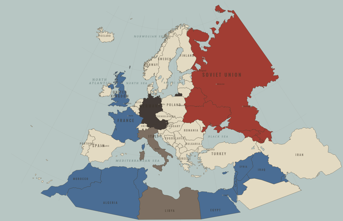
What was Austria before it was Austria? Below, every era of this land in the Maps of History atlases — who ruled it, what it was called, and when control changed — each line linked to the dated map that shows it. Modern borders stand in as an honest approximation; every atlas says so on the map itself.
Noricum (mod. Austria) · Ancient Rome
| 264 BC | Tribal peoples & confederations — the opening position |
| Roman territory | |
| Former Roman lands (lost) |
ANCIENT ROME: EVERY CHAPTER AND MAP →
Austria · Norse and Aztecs
| Other peoples and states — the opening position |
NORSE AND AZTECS: EVERY CHAPTER AND MAP →
The Eastern March (mod. Austria) · Crusades
| Latin Christendom — the opening position |
CRUSADES: EVERY CHAPTER AND MAP →
Duchy of Austria · Mongol Empire
| Other settled powers (Jin China, Christendom, Delhi) — the opening position |
MONGOL EMPIRE: EVERY CHAPTER AND MAP →
Austria (Habsburg Empire) · Industrial Revolution
The Habsburg Empire industrialised unevenly. Vienna, Lower Austria and the ironworks of Styria grew, the Alpine railways over the Semmering and the Brenner were engineering marvels, and Bohemia was the real workshop. The empire as a whole stayed largely agrarian, and by Bairoch’s estimate its industrial output per head in 1913 was less than a third of Britain’s.
| Industrialising — the opening position | |
| Industrialising | |
| Industrialising |
INDUSTRIAL REVOLUTION: EVERY CHAPTER AND MAP →
Austria (Habsburg monarchy) · Age of Revolutions
The Habsburg monarchy: the age’s designated fire brigade. Beaten by Napoleon four times, it married him an archduchess, then hosted the Congress that rebuilt Europe around its security; Metternich ran the continent’s counter-revolution from Vienna for 33 years. 1848 nearly killed it — Vienna, Milan, Prague and Budapest all rose — but its army and its skill at playing nation against nation saved it, at the price of learning nothing.
| The conservative monarchies — the opening position |
AGE OF REVOLUTIONS: EVERY CHAPTER AND MAP →
Austria · Meiji Japan and post-Soviet Russia
| Non-aligned or stateless — the opening position |
MEIJI JAPAN AND POST-SOVIET RUSSIA: EVERY CHAPTER AND MAP →
Austria-Hungary · WWI
Austria-Hungary — this map builds it from the modern states it contained: Austria, Hungary, Czechia, Slovakia, Slovenia, Croatia, Bosnia. Eleven nationalities, two parliaments, one aging emperor; it started the war to stop South Slav nationalism and was destroyed by every nationalism at once. After 1916 it fought as Germany’s ward (Ch. 7); in October–November 1918 it dissolved in weeks, each nation declaring itself out. Rump Austria, forbidden to join Germany, was left a capital without a country.
| Germany and its allies — the Central Powers — the opening position | |
| Germany and its allies — the Central Powers | |
| Empires in collapse (1918–22) | |
| Neutral or unaligned | |
| Empires in collapse (1918–22) |
Austria · Stalin’s Soviet Union
| Nazi Germany & its allies — the opening position | |
| Nazi Germany & its allies | |
| Other states |
STALIN’S SOVIET UNION: EVERY CHAPTER AND MAP →
Austria · Road to WW2
The first country to vanish without a shot: forbidden union with Germany by two treaties, guarded by Mussolini’s divisions in 1934, sold by him in 1938. The crowds that cheered the Anschluss and the Jews scrubbing Vienna’s pavements days later are the era’s reminder that annexation is an event on a map and a catastrophe in a street.
| Neutral & unaligned — the opening position | |
| The aggressors (Japan, Germany, Italy) |
ROAD TO WW2: EVERY CHAPTER AND MAP →
Austria · WW2
Annexed in 1938 (Ch. 1) to crowds both jubilant and terrorized — debate continues over “first victim” versus “willing participant.” The numbers argue both ways: a plebiscite no one could safely refuse returned 99% for annexation, some 1.2 million Austrians served in German uniform, and Austrians were over-represented in the SS and the camp system — while Vienna’s 180,000 Jews were driven into exile or murdered. The Allies’ 1943 Moscow Declaration named Austria “the first victim,” a diplomatic formula postwar Austria gratefully adopted; the honest reckoning waited until the 1980s. Restored in 1945, permanently neutral from 1955.
| Axis powers — the opening position | |
| Axis powers | |
| Defeated Axis (occupied) | |
| Western Allies |
Austria · Cold War
| NATO & core Western allies — the opening position | |
| Non-aligned & neutral | |
| Non-aligned & neutral |
COLD WAR: EVERY CHAPTER AND MAP →
Austria · Feminism and the Tunisian Revolution
| Right won in law — the opening position | |
| No reform yet / outside this story | |
| Right won in law |
FEMINISM AND THE TUNISIAN REVOLUTION: EVERY CHAPTER AND MAP →
Austria · Refugee crises
Austria was treated as Hitler’s first victim and occupied by four powers until the State Treaty of 1955, which made it neutral. It hosted DP camps and hundreds of thousands of ethnic German refugees after the war, then in 1956 became the first-asylum state for about 180,000 Hungarians. Its reception camp at Traiskirchen, opened that November, remains the country’s main centre for asylum seekers.
| Germany and Austria occupied — the opening position | |
| First asylum open | |
| Neutral or between the blocs |
REFUGEE CRISES: EVERY CHAPTER AND MAP →
Related
THE FREE PRINTABLE STUDY GUIDE
Join the Dispatch — a short welcome series, then a letter when a new atlas opens — and a printable atlas study guide of your choice is yours now, free.
NO TRACKING · YOUR ADDRESS IS USED FOR THE DISPATCH AND NOTHING ELSE · UNSUBSCRIBE ANYTIME