ONE LAND · 13 ATLASES
History of Iran in maps
Iran as it appears in 13 interactive history atlases, from 264 BC to 2000: Parthia/Persia, Persia, Iran. Each era below lists who ruled the land and when control changed, linked to the dated map that shows it.
WW2 is free — every chapter. No sign-up.
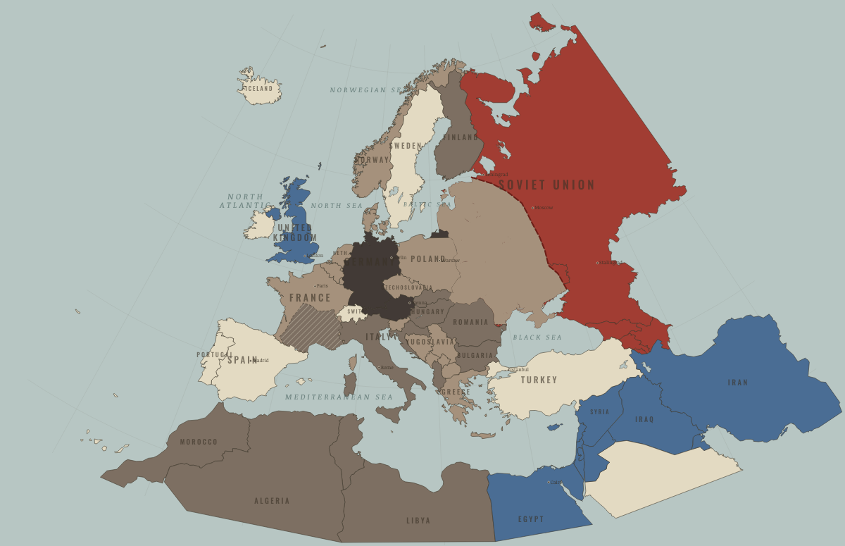
What was Iran before it was Iran? Below, every era of this land in the Maps of History atlases — who ruled it, what it was called, and when control changed — each line linked to the dated map that shows it. Modern borders stand in as an honest approximation; every atlas says so on the map itself.
Parthia/Persia (mod. Iran) · Ancient Rome
Parthia, then Sasanid Persia — the rival Rome could never remove. Parthia annihilated Crassus at Carrhae (53 BC) and swallowed Trajan’s conquests within a year of his death; the Sasanids from 224 were worse: a peer state that sacked Antioch and captured the emperor Valerian alive (Ch. 8). Seven centuries of Roman-Persian war ended only when the Arab conquests took both contestants’ richest lands.
| 264 BC | Hellenistic kingdoms — the opening position |
| 146 BC | Rival great powers |
ANCIENT ROME: EVERY CHAPTER AND MAP →
Persia (Khwarazm, then Ilkhanate) · Mongol Empire
Persia under the Khwarazm-shahs was annihilated 1219–21 — Khorasan’s golden cities became the war’s deliberate message — then rebuilt as the Ilkhanate after Hülegü (1256), with Tabriz as capital and Maragha’s observatory nearby. The dynasty that burned Baghdad converted to Islam within two generations and presided over a Persian literary and historiographical golden age. Both halves of that sentence are true; hold them together.
| The Islamic powers — the opening position | |
| The Mongol Empire |
MONGOL EMPIRE: EVERY CHAPTER AND MAP →
Persia (mod. Iran) · Industrial Revolution
| Opened by force or treaty — the opening position | |
| Opened by force or treaty |
INDUSTRIAL REVOLUTION: EVERY CHAPTER AND MAP →
Iran · Age of Revolutions
| Neutral / uncommitted — the opening position |
AGE OF REVOLUTIONS: EVERY CHAPTER AND MAP →
Iran · Meiji Japan and post-Soviet Russia
| Western powers and allies — the opening position | |
| Non-aligned or stateless |
MEIJI JAPAN AND POST-SOVIET RUSSIA: EVERY CHAPTER AND MAP →
Persia · Russian Revolution
Persia was a theatre of the “Great Game” turned civil-war sideshow: British and Soviet forces both operated on its soil, and a short-lived Soviet republic rose in Gilan on the Caspian. A weak state whose north Moscow treated as a sphere of influence.
| Neutral or independent — the opening position |
RUSSIAN REVOLUTION: EVERY CHAPTER AND MAP →
Persia / Iran · Indian independence
Persia spent the era as the other Great Game board: partitioned into Anglo-Russian “spheres” in 1907, occupied in both world wars (the 1941 Anglo-Soviet invasion deposed Reza Shah for leaning German), its oil — D’Arcy’s 1908 strike, the Anglo-Persian company, the navy’s fuel — making it too important to be left alone. From Tehran the lesson of India’s 1947 read differently: empires retreat, but from oil they retreat last. Mossadegh tested that reading in 1951; the answer came in 1953.
| Beyond the Raj · Portuguese & French India — the opening position |
INDIAN INDEPENDENCE: EVERY CHAPTER AND MAP →
Persia · WWI
Persia — a constitutional revolution in 1905–06 gave it a written constitution and an elected parliament, the Majlis, and within a year Britain and Russia had divided the country over its head into spheres of influence, zones where each claimed the sole right to trade, lend and advise (Ch. 1). Russian pressure closed the Majlis in 1911, and in the world war Persia, though it declared itself neutral, was crossed at will by Russian, British and Ottoman armies. Oil, struck in 1908 in the unassigned south-west, made southern Persia vital to Britain, which added that middle zone to its sphere in 1915.
Iran (Persia) · Stalin’s Soviet Union
Iran was invaded by British and Soviet forces in August 1941 to secure its oil and a supply route for Lend-Lease aid to the Soviet Union. After the war Soviet troops stayed in the north and backed separatist governments in Iranian Azerbaijan and Kurdistan. Under American pressure and Iranian diplomacy they withdrew in May 1946, and the separatist governments collapsed.
STALIN’S SOVIET UNION: EVERY CHAPTER AND MAP →
Iran · Road to WW2
| Neutral & unaligned — the opening position |
ROAD TO WW2: EVERY CHAPTER AND MAP →
Iran · WW2
Jointly occupied by Britain and the USSR in August 1941 to secure the “Persian Corridor” — the truck route delivering 8 million tons of Lend-Lease aid to the USSR. Small nations’ sovereignty routinely yielded to great-power logistics; Iran remembers.
| Western Allies — the opening position | |
| Western Allies |
Iran · Cold War
The Cold War’s northern-tier prize: jointly occupied in the war, its elected premier deposed by a CIA–MI6 coup in 1953 for nationalizing oil, its Shah armed as the Gulf’s policeman — until 1979, when revolution removed it from both columns at once (Ch. 10). The era’s interventions are the first chapter of every explanation of Iran since.
| US-aligned states — the opening position | |
| Non-aligned & neutral | |
| Non-aligned & neutral |
COLD WAR: EVERY CHAPTER AND MAP →
Iran · Refugee crises
REFUGEE CRISES: EVERY CHAPTER AND MAP →
Related
THE FREE PRINTABLE STUDY GUIDE
Join the Dispatch — a short welcome series, then a letter when a new atlas opens — and a printable atlas study guide of your choice is yours now, free.
NO TRACKING · YOUR ADDRESS IS USED FOR THE DISPATCH AND NOTHING ELSE · UNSUBSCRIBE ANYTIME