ONE LAND · 11 ATLASES
History of Tajikistan in maps
Tajikistan as it appears in 11 interactive history atlases, from 1206 to 2000: Badakhshan, Tajikistan, Russian Turkestan, Soviet Central Asia. Each era below lists who ruled the land and when control changed, linked to the dated map that shows it.
WW2 is free — every chapter. Try chapters 1–2 of any 2 other atlases (3 with a free account). Opening a new atlas uses one of them. Membership opens all 21 — Join.
Free printable Russian Revolution study guide, sent by email ↓
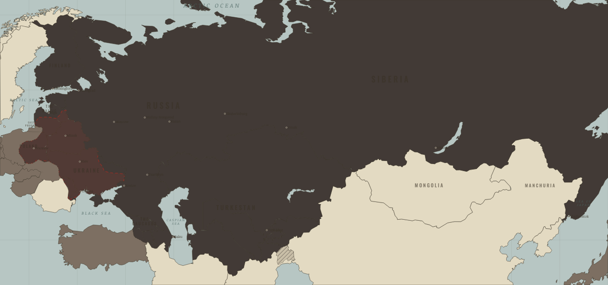
What was Tajikistan before it was Tajikistan? Below, every era of this land in the Maps of History atlases — who ruled it, what it was called, and when control changed — each line linked to the dated map that shows it. Modern borders stand in as an honest approximation; every atlas says so on the map itself.
Badakhshan (mod. Tajikistan) · Mongol Empire
| The Islamic powers — the opening position | |
| The Mongol Empire |
MONGOL EMPIRE: EVERY CHAPTER AND MAP →
Tajikistan · Industrial Revolution
| Colony or dependency — the opening position | |
| Colony or dependency |
INDUSTRIAL REVOLUTION: EVERY CHAPTER AND MAP →
Tajikistan · Meiji Japan and post-Soviet Russia
Tajikistan, the poorest Soviet republic, fell into civil war soon after independence, between the old communist elite and an opposition of Islamists and democrats. Estimates of the dead range from about 20,000 to 100,000, most of them killed in 1992, and around a million people were displaced. Russian troops guarded the Afghan border, and a peace agreement signed in Moscow in 1997 ended the war, hatched on the map in 1993.
| The USSR, then Russia — the opening position | |
| Independent neighbours | |
| War, rebellion, breakaway | |
| Independent neighbours |
MEIJI JAPAN AND POST-SOVIET RUSSIA: EVERY CHAPTER AND MAP →
Russian Turkestan (mod. Tajikistan) · Russian Revolution
The north came to Russia when it took Khujand in 1866, the centre and south came under Russian control through the Bukharan protectorate, and the Pamirs were settled only by the Anglo-Russian agreement of 1895. The Tajik lands, part of the emirate of Bukhara and Russian Turkestan, were among the last reconquered. The Basmachi insurgency was fiercest here and lasted, on and off, into the mid-1920s — the civil war’s long tail in Central Asia.
| Neutral or independent — the opening position | |
| The Tsarist empire | |
| Provisional Government, then the Whites | |
| Contested / peasant war | |
| Soviet power |
RUSSIAN REVOLUTION: EVERY CHAPTER AND MAP →
Russian Turkestan (mod. Tajikistan) · Indian independence
The Pamir knot, where the Great Game was surveyed to a finish: the 1895 boundary commission drew the Wakhan corridor — a panhandle of Afghanistan kept deliberately between the two empires so that Russia and British India would nowhere touch. Basmachi rebels fought Soviet power in these valleys into the 1930s while the Raj watched from Gilgit. The corridor remains on every modern map: the era’s clearest surviving artifact of borders drawn purely so that empires need not meet.
| Beyond the Raj · Portuguese & French India — the opening position |
INDIAN INDEPENDENCE: EVERY CHAPTER AND MAP →
Tajikistan · WWI
| The Entente & Allies — the opening position | |
| Russia in revolution |
Soviet Central Asia (mod. Tajikistan) · Chinese Revolution
| Foreign empires — British, French, Russian, American — the opening position |
CHINESE REVOLUTION: EVERY CHAPTER AND MAP →
Tajikistan (Tajik SSR from 1929) · Stalin’s Soviet Union
Tajikistan began as an autonomous republic inside the Uzbek republic in 1924 and became a union republic of its own in 1929, when its capital, the market village of Dushanbe, was renamed Stalinabad. Armed resistance to Soviet rule, which the Soviets called the Basmachi, lasted in its mountains into the early 1930s. Its Pamir range held the Union’s highest summit, which became Stalin Peak in 1933.
| The Soviet Union — the opening position |
STALIN’S SOVIET UNION: EVERY CHAPTER AND MAP →
Tajikistan · Road to WW2
| Neutral & unaligned — the opening position | |
| Aggressor clients & partners | |
| Democracies & powers fighting them |
ROAD TO WW2: EVERY CHAPTER AND MAP →
Tajikistan · Cold War
| USSR & Warsaw Pact — the opening position | |
| Non-aligned & neutral |
COLD WAR: EVERY CHAPTER AND MAP →
Soviet Central Asia (mod. Tajikistan) · Mao’s China
| Beijing’s allies and friends — the opening position | |
| Beijing’s adversaries |
MAO’S CHINA: EVERY CHAPTER AND MAP →
Related
THE FREE PRINTABLE STUDY GUIDE
Join the Dispatch — a short welcome series, then a letter when a new atlas opens — and a printable atlas study guide of your choice is yours now, free.
NO TRACKING · YOUR ADDRESS IS USED FOR THE DISPATCH AND NOTHING ELSE · UNSUBSCRIBE ANYTIME