MAPS OF HISTORY · The Road to War · ALL CHAPTERS · CHAPTER 6
CHAPTER 6 · 1937–1938 · 1938
China: The War Nobody Declared
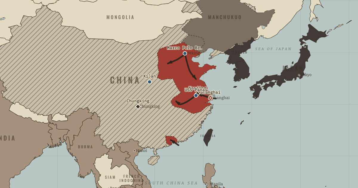
The map above is the world of OCT 1938 — Wuhan and Canton fall.
BRIEF EXPLANATION — THE ESSENTIAL ARGUMENT
The war between Japan and China that began in 1937 shows how earlier unpunished aggression makes later escalation almost automatic. A minor clash at the Marco Polo Bridge outside Peking grew into a full war because both sides had absorbed a lesson from the years before. Japanese field commanders expected that any advance would be reinforced and then approved in Tokyo, while China, having already surrendered Manchuria and Jehol, could not afford another retreat without losing all authority. Rather than fight only in the north, Chiang Kai-shek deliberately opened a second and larger battle at Shanghai, both to resist and to fight where the world’s cameras and foreign interests would be forced to notice.
Japan captured the coast, the major cities and the capital at Nanjing, where its forces murdered prisoners and civilians and committed mass sexual violence on a scale this atlas marks as memory rather than spectacle. China’s response was to trade space for time, moving its government, industry and universities far inland and continuing to fight from the interior. The result was a strategic deadlock that decided the character of the whole war. Japan held the richest cities and the rail corridors between them yet could not compel a surrender, so its victory hardened into an occupation that consumed more resources than it produced.
GUIDED EXPLANATION
A clash near the Marco Polo Bridge on 7 July 1937 escalated into a general war that neither government had ordered, and the reason lies in the habits both sides had formed. Japanese field commanders reinforced first and reported afterward, confident of approval, while Chiang Kai-shek could no longer retreat without forfeiting his political authority. China then opened a major battle at Shanghai, choosing to resist on the one ground where foreign observers would be compelled to watch.
Japan captured Shanghai and drove on to Nanjing, where its forces murdered prisoners and civilians and committed mass sexual violence, with estimates of the dead ranging widely from tens of thousands to more than 300,000. This marker is memorial rather than spectacle. By late 1938 Japan controlled the great cities and the routes between them, yet Chiang’s government had escaped inland to Chongqing, and the front lines froze because occupation had not produced surrender. Japan had enlarged the war beyond its power to end it.
The mechanism was escalation shaped by earlier concessions. Japanese commanders had learned at Mukden that success would be ratified after the fact, and Chinese leaders had learned that every retreat merely invited the next demand, so neither side could easily step back. The Xi’an Incident of December 1936, in which Chiang was kidnapped and forced into an uneasy united front with the Communists against Japan, had already closed China’s path of appeasement. At Shanghai Chiang committed his best divisions where foreign eyes would see the war, and although the battle won him sympathy it cost him much of that trained force. Retreat then became a strategy in itself, the trading of space for time, since moving government, industry and universities inland lengthened Japan’s supply lines and preserved the means of resistance. The cost fell heavily on civilians, most brutally when the Nationalists breached the Yellow River dikes in 1938 to slow the advance. Japan held the cities and railways but never had the forces to control China’s vast interior or to force the political surrender it needed.
DEEP EXPLANATION — EVIDENCE & INTERPRETATION
Escalation without declaration
Neither government set out to fight a general war at the Marco Polo Bridge, and the clash became one because the behaviour of the previous years had already shaped what each side expected. Japanese field officers had learned from Manchuria that escalation would be ratified in Tokyo, while Chinese leaders had learned that concession only invited the next demand and that their own legitimacy now depended on resistance. Reinforcements sent to strengthen a bargaining position made the other side fear being caught at a disadvantage, so each precaution fed the spiral. Both governments also avoided a formal declaration of war, because American neutrality law might otherwise cut off trade, and Japan in particular relied on imported fuel and scrap. That legal ambiguity let material support keep flowing into a conflict everyone recognised as a war. The episode illustrates path dependence, in which earlier unpunished advances raise the political cost of restraint until even leaders who would prefer a local settlement can no longer reach one.
Trading space for time
Chiang’s strategy kept a functioning government alive by retreating inland, relocating industry, and stretching Japanese supply lines until they became a burden. Japan could occupy cities and railways far more easily than the countryside that lay between them, so continued Chinese resistance denied Tokyo the swift political victory its short-war assumptions had required and pinned down large forces for years. The logic of the strategy does not erase its human cost. Nationalist decisions, above all the breaching of the Yellow River dikes in 1938, caused immense civilian death and displacement, and the civilians who paid had little say in whether their suffering was worth the time it bought. Historians therefore weigh effectiveness and legitimacy separately, recognising that withdrawal helped prevent national surrender while some of the methods used to delay Japan were brutally coercive. That distinction matters whenever a weaker state relies on depth and endurance instead of immediate battlefield superiority.
New here? Chapters 1–2 of every atlas are free to sample, and the WW2 atlas is free in full. One membership opens all thirteen — the Cartographer’s Circle.
THE SITES
ON THIS DAY
WHY IT HAPPENED
Xi’an closed China’s exit. Until December 1936, Tokyo could reasonably expect Chiang to keep appeasing — he had absorbed Manchuria, Jehol, and creeping “autonomy” in north China while hunting communists. The Xi’an kidnapping, engineered by the Manchurian marshal Zhang Xueliang whose homeland Japan had taken, forced the United Front: Nationalists and Communists nominally together against the next encroachment. When the next encroachment came at Marco Polo Bridge, both Chinese unity and Chinese opinion had foreclosed the concession option — a fact Japanese planners, reading old files, discounted.
Japan’s command rewarded escalation. The field armies that had profited from Mukden’s insubordination (Ch. 2) ran the same play: local commanders reinforced first and informed Tokyo afterward, confident the cabinet would ratify success. The general staff’s “expansionists” argued one sharp blow would collapse Chinese resistance in three months — the war-planning cliché of the century. The army that answered to no one had finally found an enemy too large to be conquered by indiscipline.
Chiang chose Shanghai to internationalize the war. Committing his modern divisions to a coastal city under naval guns was strategically perverse. Politically, however, Shanghai was calculated. It moved the war from the remote north to the doorstep of the International Settlement. Western witnesses now watched while their factories and citizens stood in the line of fire. The gamble half-worked. It bought China worldwide sympathy, the Soviet aid treaty of August 1937 and eventual American credits. It did not bring the intervention Chiang needed, and it cost him the army built by a decade of German advisers.
No one would name the war. Japan called the conflict the “China Incident” to avoid triggering the US Neutrality Acts. Those laws would have embargoed arms to both sides, while Japan still bought American scrap iron and oil. China avoided a declaration for the mirror-image reason: it wanted to keep its supply channels open. The largest war on earth therefore ran formally nameless for four years. That legal fiction had real consequences. Washington could keep fueling Japan’s war machine while sympathizing with its victim. Chapter 10 follows this ambiguity as it hardens into embargo.
THE TURN
The Marco Polo Bridge, 7 July 1937. The bridge matters because it proves the era’s darkest mechanism: by 1937 the structures of aggression — an unaccountable field army, a national ideology of encirclement, a victim whose patience had a fixed bottom — had made a world-historical war startable by a missing private. Historians disagree on inevitability: some argue the incident genuinely could have been contained (unlike Mukden, nobody planned it); others answer that if not this spark, then the next — Japan’s north China policy was a spark-manufacturing machine. Both positions teach the same seminar lesson: contingency and structure are not rivals. Structure loads the gun; contingency is merely the trigger finger.
WHAT IT CHANGED
The quagmire turns Japan’s eyes south. A million Japanese troops sink into China; the resources the war consumes exceed the resources it yields. The strategic conclusion Tokyo reaches by 1940 — that the China war can only be won by cutting Chiang’s supply lines and seizing resources in Southeast Asia — is the road to Pearl Harbor, walked in Chapter 10.
Atrocity begins to move American policy. Nanjing, the Panay, and newsreel bombing of Chinese cities shifted the American public from indifference to boycotts of Japanese silk; Roosevelt’s October 1937 “quarantine” speech tested the water for pressure. Policy lagged opinion by years — but the moral ledger that ended in embargo was opened here.
China’s endurance becomes an Allied asset. By refusing to surrender, China pinned the majority of the Japanese army for eight years — the fact Churchill and Roosevelt would count on after 1941, and the reason China ended the war as one of the “Big Four” with a permanent Security Council seat. The chapter’s frozen front line is, in the long view, a load-bearing wall of the Allied war.
FIELD QUESTION — Chiang Kai-shek traded a third of China for time. Was “trading space for time” a strategy or an excuse?
The case for excuse writes itself. The Nationalists lost every major battle of 1937–38, and the retreat was chaotic and often callous. In June 1938 they deliberately breached the Yellow River dikes. The flood slowed Japan for months but drowned or starved hundreds of thousands of Chinese people. The decision was as ruthless as anything an occupier ordered. The case for strategy is visible on the map. Japan’s armies could hold cities and rail lines but not the space between them. Every kilometre of advance lengthened supply lines and multiplied garrisons. The government that fled to Chungking was still fighting in 1945, an outcome Tokyo’s three-month theory had called impossible. Most military historians therefore grant the strategy’s logic while counting its costs in the same breath. Peasants who were never consulted paid those costs. The underlying seminar question remains: when attritional suffering is a weaker power’s only winning strategy, who has the right to choose it?
AN INTERESTING FACT
Free China’s wartime lifeline was built by hand. When the coastal ports fell, some 200,000 labourers — farmers, women, children, with baskets and hoes — carved the Burma Road: 1,150 kilometres of switchbacks from Lashio in British Burma over the Hengduan ranges to Kunming, opened in 1938 after roughly a year of work. Trucks on it carried the imports that kept the Chungking government armed; its closure and reopening became matters of world diplomacy (Churchill shut it for three months in 1940 under Japanese pressure). The road the war’s poorest participants built with hand tools appears on the strategic maps of every great power of the era.
THE DISPATCH
One short letter when a new atlas opens — and the printable study guide for The Road to War is yours now, free.
NO TRACKING · YOUR ADDRESS IS USED FOR THE DISPATCH AND NOTHING ELSE · UNSUBSCRIBE ANYTIME