ONE LAND · 11 ATLASES
History of North Korea in maps
North Korea as it appears in 11 interactive history atlases, from 1206 to 2000: Goryeo, Korea — north, Korea, North Korea, Chōsen — Japanese Korea, Chosen — Japanese Korea. Each era below lists who ruled the land and when control changed, linked to the dated map that shows it.
WW2 is free — every chapter. No sign-up.
What was North Korea before it was North Korea? Below, every era of this land in the Maps of History atlases — who ruled it, what it was called, and when control changed — each line linked to the dated map that shows it. Modern borders stand in as an honest approximation; every atlas says so on the map itself.
Goryeo (mod. North Korea) · Mongol Empire
Goryeo endured six invasions from 1231 while its court sat out the storm on Kanghwa island; the peninsula burned, and in 1259 the crown prince submitted. Korea kept its king — as Mongol in-law — and paid in shipyards: the Japan armadas of 1274 and 1281 were largely Korean-built, by corvée the kingdom begged relief from.
| Other settled powers (Jin China, Christendom, Delhi) — the opening position | |
| Tributaries & vassals |
MONGOL EMPIRE: EVERY CHAPTER AND MAP →
Korea — north (Japanese from 1910) · Industrial Revolution
| Opened by force or treaty — the opening position | |
| Opened by force or treaty | |
| Colony or dependency |
INDUSTRIAL REVOLUTION: EVERY CHAPTER AND MAP →
Korea (Joseon, then Japanese Chōsen; mod. North Korea) · Meiji Japan and post-Soviet Russia
The northern half of the old Korean kingdom shares its nineteenth-century history: the Japanese settlement imposed at Wonsan in 1880, the battle of Pyongyang in 1894 and annexation in 1910. After 1945 it became a communist state allied to Moscow and Beijing yet outside the Soviet bloc. When Soviet aid and cheap oil ended in 1991, its economy collapsed and famine followed in the mid-1990s, a cost of the Soviet transition paid far from Moscow.
| Independent neighbours — the opening position | |
| Domains, vassals, protectorates | |
| Meiji Japan and its empire |
MEIJI JAPAN AND POST-SOVIET RUSSIA: EVERY CHAPTER AND MAP →
Korea (Japanese) · Russian Revolution
Korea was a kingdom under Qing protection until 1895 and then the independent Korean Empire until Japan occupied it in 1904, so before that date it is shown as neutral. Annexed by Japan in 1910, it appears from 1904 as a Japanese possession — a reminder that the Russian Far East was one edge of an expanding Japanese empire whose ambitions in Manchuria and Siberia shaped the intervention.
| Neutral or independent — the opening position | |
| Foreign powers & intervention |
RUSSIAN REVOLUTION: EVERY CHAPTER AND MAP →
North Korea · WWI
| Entente-aligned & imperial territories — the opening position | |
| Entente-aligned & imperial territories |
Chōsen — Japanese Korea (mod. North Korea) · Chinese Revolution
The northern half of Japanese Chōsen, industrialized as the colony’s arsenal — dams, chemicals, mines — and occupied by the Soviet army in August 1945. The guerrillas who return with it, Kim Il-sung’s Manchurian partisans, had fought their war inside this map: the Kapsan raids into the border country were part of the same anti-Japanese resistance world as the Chinese base areas. The state they build mirrors the era’s lesson — party, army, leader — and its 1950 war pulls the new China back onto this peninsula within a year of the PRC’s founding.
| The Empire of Japan & its puppets — the opening position | |
| Foreign empires — British, French, Russian, American |
CHINESE REVOLUTION: EVERY CHAPTER AND MAP →
Korea (north) · Stalin’s Soviet Union
Korea was a Japanese colony until 1945, when Soviet troops occupied the north and American troops the south. In the Soviet zone a former Red Army captain, Kim Il Sung, was installed as leader, and the Democratic People’s Republic was proclaimed in 1948. In 1950 Stalin approved Kim’s invasion of the south, starting the Korean War, which the Cold War atlas follows.
| Rivals & the Western bloc — the opening position | |
| Satellites & communist allies |
STALIN’S SOVIET UNION: EVERY CHAPTER AND MAP →
Chosen — Japanese Korea · Road to WW2
| The aggressors (Japan, Germany, Italy) — the opening position |
ROAD TO WW2: EVERY CHAPTER AND MAP →
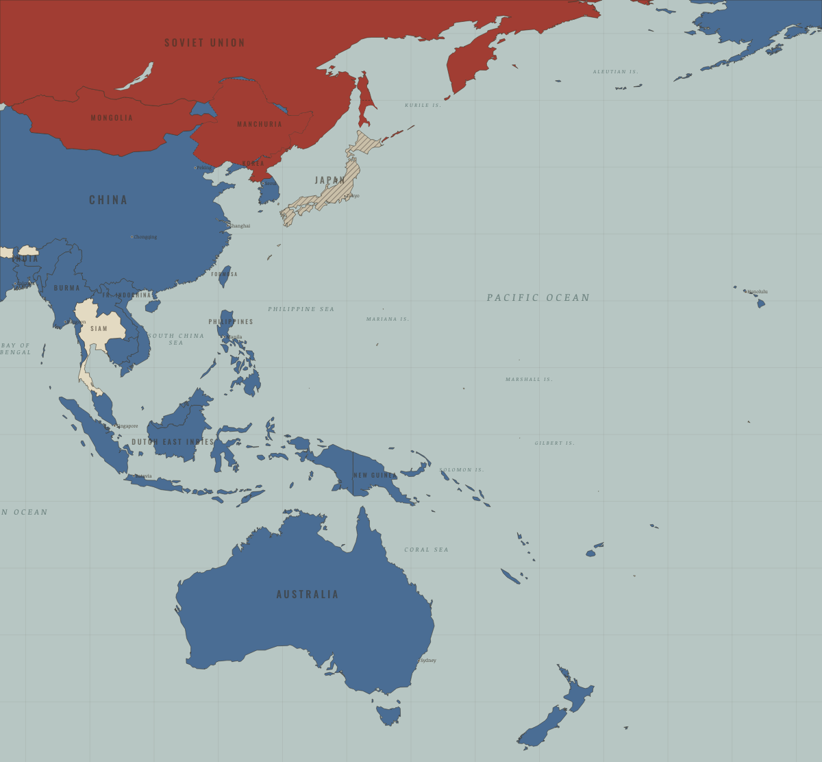
North Korea · WW2
The Soviet-occupied northern zone of liberated Korea; by 1948 a separate communist state under Kim Il-sung, a former anti-Japanese guerrilla. The 1950 invasion of the South made the 38th parallel the Cold War’s hottest line.
| Axis powers — the opening position | |
| Soviet Union |
North Korea · Cold War
The Soviet occupation zone that became a hereditary totalitarian state. Its gamble of June 1950 killed millions and won nothing; the American bombing it endured (Ch. 4) remains the core of its official memory and its nuclear logic. It outlived its patron: the 1991 map shows it charcoal — communist, alone, armed.
| Soviet-aligned states — the opening position | |
| Communist, outside Moscow’s bloc |
COLD WAR: EVERY CHAPTER AND MAP →
North Korea (the DPRK) · Mao’s China
North Korea’s invasion of the South in June 1950, approved by Stalin, brought China into its first war as the People’s Republic. Chinese troops saved Kim Il-sung’s state and stayed until 1958. Kim then played Beijing and Moscow against each other, borrowing from both and proclaiming his own ideology of self-reliance, juche. The Korean border along the Yalu was China’s most dangerous frontier until the Soviet clashes of 1969.
| Beijing’s allies and friends — the opening position |
MAO’S CHINA: EVERY CHAPTER AND MAP →
Related
THE FREE PRINTABLE STUDY GUIDE
Join the Dispatch — a short welcome series, then a letter when a new atlas opens — and a printable atlas study guide of your choice is yours now, free.
NO TRACKING · YOUR ADDRESS IS USED FOR THE DISPATCH AND NOTHING ELSE · UNSUBSCRIBE ANYTIME