The Mongol Empire, 1206–1294 · THE MAP IN
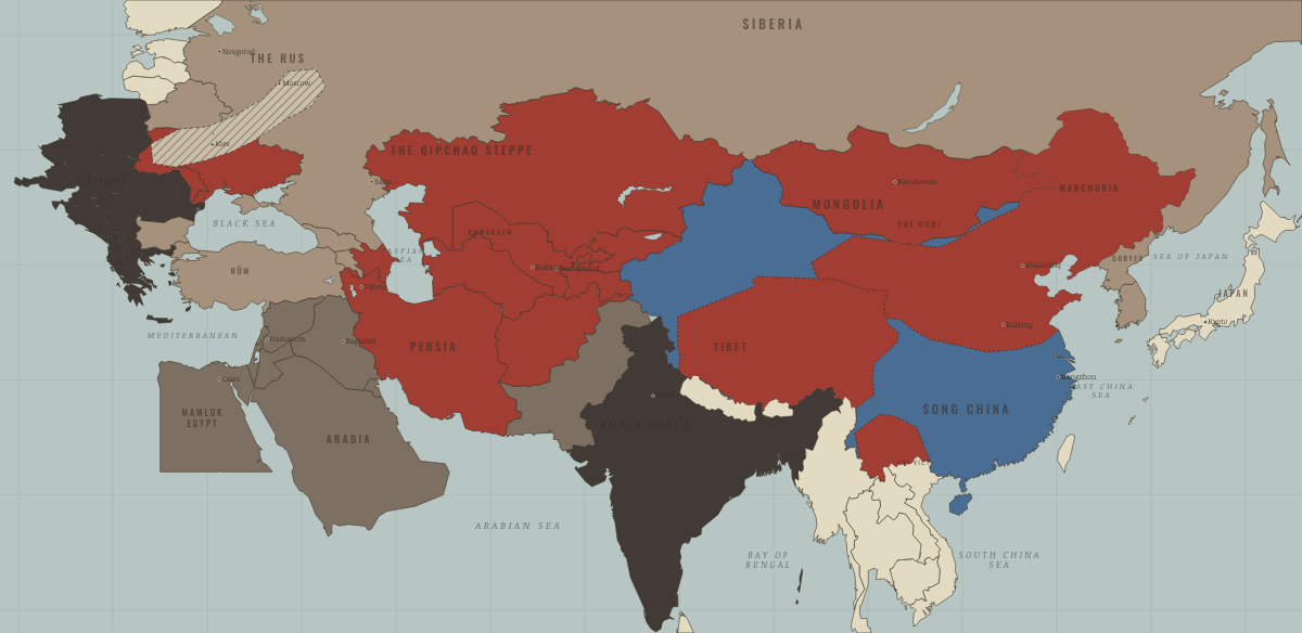
Map of the Mongol Empire in 1254
The empire of Möngke
The Mongol Empire in 1254: The empire of Möngke. Since 1242, 3 territories changed status on this map: Goryeo (mod. North Korea), Goryeo (mod. South Korea) and Arran & Shirvan (mod. Azerbaijan).
Open this map in the interactive atlas →
WW2 is free — every chapter. Try chapters 1–2 of any 2 other atlases (3 with a free account). Opening a new atlas uses one of them. Membership opens all 21 — Join.
What changes on the map
| Goryeo (mod. North Korea) | Other settled powers (Jin China, Christendom, Delhi) → Tributaries & vassals |
| Goryeo (mod. South Korea) | Other settled powers (Jin China, Christendom, Delhi) → Tributaries & vassals |
| Arran & Shirvan (mod. Azerbaijan) | The Islamic powers → The Mongol Empire |
On the ground
- Yunnan — the Dali kingdom, taken by Khubilai’s flanking march of 1253
- Tibet under Mongol overlordship — the Sakya priest–patron pact of 1247
The chapters of this moment
Related maps
THE FREE PRINTABLE STUDY GUIDE
Join the Dispatch — a short welcome series, then a letter when a new atlas opens — and the printable study guide for The Mongol Empire is yours now, free.
NO TRACKING · YOUR ADDRESS IS USED FOR THE DISPATCH AND NOTHING ELSE · UNSUBSCRIBE ANYTIME