MAPS OF HISTORY · China in Revolution · ALL CHAPTERS · CHAPTER 8
CHAPTER 8 · 1937–1938 · 1938
The Japanese War Begins
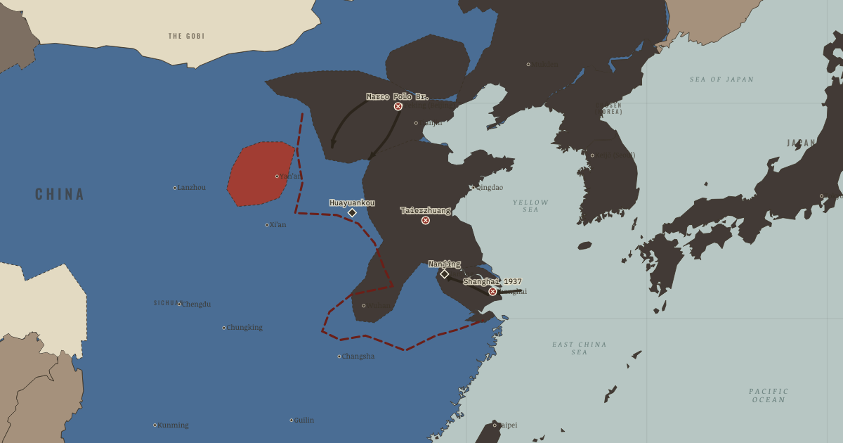
The map above is the world of 1938 — Wuhan and Canton — the stalemate line.
BRIEF EXPLANATION — THE ESSENTIAL ARGUMENT
The clash at Marco Polo Bridge in July 1937 escalated into full war because neither Tokyo nor Chiang could accept another retreat. Japan drove fast along the northern railways, where its mechanized armies were strongest. Chiang answered by forcing a major battle at Shanghai, both to slow the invasion and to make Chinese resistance visible to the wider world, and the three months of fighting there destroyed many of his best-trained divisions.
After Nanjing fell, Japanese forces committed mass murder and mass rape on a scale that estimates dispute but the fact of which they do not. The Nationalist government moved inland and kept fighting rather than surrender. Taierzhuang proved that Japan could be beaten locally, while the deliberate breaching of the Yellow River dikes slowed the advance at an immense civilian cost and still failed to save Wuhan. By late 1938 the front had frozen into the divided country the next chapter examines.
GUIDED EXPLANATION
“Space for time” meant surrendering territory in order to preserve enough forces and government to keep the war going. It began with an incident far too small for the war it started. During a night exercise a Japanese soldier went missing at roll call, and shots were exchanged in the dark at a stone bridge southwest of Peking (the ✕ at Marco Polo Bridge, 7 July 1937). Local commanders nearly settled it, as they had settled a dozen such incidents since 1931, but this time Tokyo reinforced. Chiang also refused to back down, because his currency was reformed, his German-trained divisions were ready enough, and his legitimacy had been mortgaged at Xi’an to resistance. Two charcoal arrows drove south from the Peking–Tianjin plain along the railways into Hebei and Shanxi, Japan’s war of lines, fast and mechanized and unstoppable in the open north. The other two arrows belong to the war Chiang chose. In August he attacked the Japanese garrison in Shanghai (the ✕ there), deliberately pulling the main war onto the Yangtze axis. There rivers, cities and mud favored the defender, and the world, watching from the International Settlement’s rooftops, could not ignore it. Three months of house-by-house fighting consumed his best divisions, with casualties approaching a quarter-million, including the irreplaceable junior officers Whampoa had spent a decade making.
What follows sits on this map as memory rather than as argument. The capital fell on 13 December, and for weeks the Japanese army murdered prisoners and civilians and raped on a mass scale (the ◆ at Nanjing). The postwar tribunal counted more than 200,000 dead, Chinese memory holds 300,000, and the range is argued to this day, though the fact of the atrocity is not. The government did not surrender. It moved instead, upriver to Wuhan and ultimately to Chungking, taking universities, arsenals and a refugee nation with it. In the spring the war’s pattern showed itself at Taierzhuang (the ✕), where Li Zongren’s regional armies encircled and mauled two Japanese brigades in a canal town. It was China’s first clear victory, worth divisions in morale, and proof that the invader could be made to bleed for ground. Then came the price of slowing him. In June, to buy time in front of Wuhan, Nationalist engineers breached the Yellow River dikes at Huayuankou (the ◆) without warning the villages below. The river swung south, hundreds of thousands drowned or starved, and millions fled, all to delay Japan by months. Wuhan and Canton fell anyway in October, and the front line the map now wears is the result. The war then settled into the shape it would keep for six years: Japan held the charcoal east, the government held the vast interior, and neither could reach the other’s heart.
DEEP EXPLANATION — EVIDENCE & INTERPRETATION
Why the Nanjing toll is contested, and why the contest is not the fact
The dead of Nanjing are memorialized here rather than tallied for effect, but honesty requires explaining why the numbers differ. The postwar Tokyo tribunal counted more than 200,000, the official figure in China is 300,000, and a few Japanese historians argue for lower totals. The gap has real evidentiary roots, because the Japanese army destroyed records, the killing spread over roughly six weeks and well beyond the walled city, and burial-society and refugee data are incomplete. It has also been poisoned by a denialist current in Japanese politics that treats a smaller number as an exoneration, which it is not. Serious historians of every nationality, with Timothy Brook’s documentary collections a standard reference, affirm a mass atrocity against prisoners and civilians on a scale no arithmetic can soften. The discipline this teaches any student of atrocity is to hold two truths at once: precise counts are frequently unrecoverable, and their unrecoverability is never evidence that the crime was small.
The flood: when the defender becomes the danger
The breaching of the Yellow River dikes at Huayuankou in June 1938 is the hardest case in the atlas’s doctrine of “space for time,” and it should not be filed away as a mere delaying tactic. To slow the Japanese drive on Wuhan, Nationalist engineers deliberately cut the levees without warning the villages below. The river swung south across the plain, drowning or starving hundreds of thousands and displacing millions, and it did buy months. Historians such as Diana Lary and Micah Muscolino have reconstructed the human ecology of the disaster, tracing a straight line from the 1938 flood, which wrecked the drainage and cropland of Henan, to the famine of 1942–43 that killed perhaps two million more. The episode forces the question that a strategy of endurance always eventually poses, which is at what point the cost a state inflicts on its own people to survive comes to exceed the value of the survival. On this map it stands as a memorial marker rather than a maneuver.
New here? Chapters 1–2 of every atlas are free to sample, and the WW2 atlas is free in full. One membership opens all thirteen — the Cartographer’s Circle.
THE SITES
ON THIS DAY
WHY IT HAPPENED
Tokyo’s escalation machine. Japan in 1937 had no plan to conquer China — it had a government too weak to refuse its field armies’ faits accomplis, a doctrine (“one decisive blow will make Chiang submit”) renewed after each blow failed, and a domestic politics in which assassination had already priced moderation (the coups and murders of 1932–36). Each escalation was locally rational and cumulatively ruinous: the classic pattern of a state whose army audits itself.
Why Chiang chose 1937. Six years of trading space for time (Manchuria, Jehol, the Tanggu line — the dashed concession still visible on your 1933–35 maps) had bought real assets: the fabi, German-trained divisions, arsenals, roads. But Xi’an had spent his last credit for delay, and the north was being nibbled into a second Manchukuo. He fought when the alternative was presiding over erosion. He chose Shanghai to make the war expensive, visible and long. Argued strategy, paid for in his best army.
Two wars in one country. Japan’s army was built to destroy armies quickly and could. China’s strategy was to refuse the decision — trade cities for time, stretch the enemy across a continent, and wait for the world war Chiang was certain was coming. “Space for time” was announced doctrine, not improvisation. The map is the argument: by December 1938 Japan has taken every great city of eastern China and won nothing decisive.
A soldiery prepared for atrocity. Nanjing was not an aberration of discipline but a product of it: an army trained in systematic brutalization of its own ranks, indoctrinated in contempt for Chinese combatants and civilians alike, permitted — at command levels whose responsibility the Tokyo tribunal later traced — to treat a fallen capital as spoils. Naming the mechanism matters, because “chaos” is the alibi. The pattern (Nanjing 1937, and after) was policy tolerated into recurrence.
THE TURN
Marco Polo Bridge, 7 July 1937. The incident was trivial and the hinge is real: this is where both governments stopped being able to climb down — Tokyo because its army would not be overruled twice, Chiang because Xi’an had made further concession politically fatal. Every earlier incident since 1931 had been absorbed. This one compounded into eight years of war that killed tens of millions and decided, among much else, who would rule China. When you assess “accidental” wars, look for the accident that fell on ground where neither side could afford to let it lie.
WHAT IT CHANGED
The government of the interior. The retreat to Chungking is a state amputating its own richest limb to survive: customs revenue, industry and the tax base of the Yangtze delta are gone. What remains is a poor, agrarian Free China financing a total war — the fiscal wound (inflation, conscription, requisition) that Chapter 9 shows festering into political decay.
The Communists’ war opens behind the lines. The Japanese tide holds cities and railways. The countryside between them becomes politically vacant. Eighth Route Army columns walk into the vacancy within months — the mechanism (occupation displaces the old elite, resistance organizes the villages) that Chalmers Johnson would later put at the center of the whole era’s explanation.
The world takes note and takes years. The Panay sinking, the newsreels of Shanghai and the reporting of Nanjing turn American opinion. Policy follows at glacial speed: loans, then the 1940–41 embargoes on scrap and oil that put Tokyo to its Pearl Harbor choice. China’s strategy of holding until the world arrives is vindicated slowly, at Chinese expense.
FIELD QUESTION — Was Chiang right to fight in 1937 — six years after Manchuria, arguably years before he was ready?
Put the alternatives on the table honestly. Fighting in 1931 meant fighting without a currency, without the German divisions, with warlord armies he did not command — probably a faster version of 1937’s defeats without 1937’s endurance. Conceding in 1937 meant the north absorbed as a second Manchukuo, his nationalist legitimacy — the only kind he had left after Xi’an — liquidated, and a war postponed to terms likelier worse. Fighting in 1937 meant what the map shows: the coast lost, the best army spent in Shanghai’s rubble, the government exiled to the interior. Yet it also the one outcome Japan could not manufacture: a China still in the war when the world war arrived, seated (because it endured) among the eventual victors. Hans van de Ven and Rana Mitter have pushed hard against the old portrait of Nationalist incompetence: the strategy was coherent and partly worked. Its costs simply landed on a society already at the margin. The transferable discipline: judge 1937 against 1931 and 1941, not against an unavailable peace.
AN INTERESTING FACT
China moved its civilization out of the war’s path. Beginning in 1933, the Palace Museum crated the imperial collections of the Forbidden City — porcelains, paintings, bronzes, the archives of dynasties — and from 1937 shipped nearly twenty thousand crates up-country by rail, truck, sampan and porters’ poles, storing them in caves and temples in Sichuan and Guizhou for eight years. Astonishingly little was lost or broken across ten thousand kilometers of wartime evacuation. The collection’s later itinerary belongs to Chapter 12: a portion of the crates, never unpacked, sailed for Taiwan in 1948–49 — which is why there are two Palace Museums today, one in Beijing and one in Taipei.
THE DISPATCH
One short letter when a new atlas opens — and the printable study guide for China in Revolution is yours now, free.
NO TRACKING · YOUR ADDRESS IS USED FOR THE DISPATCH AND NOTHING ELSE · UNSUBSCRIBE ANYTIME