MAPS OF HISTORY · WWI · ALL CHAPTERS · CHAPTER 6
CHAPTER 6 · 1914–1918 · THE WAR AT SEA · JAN 1917
The Slowest Weapon
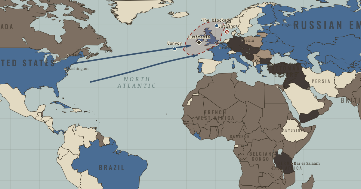
The map above is the world of APR 1917 — America comes in.
BRIEF EXPLANATION — THE ESSENTIAL ARGUMENT
The longest front of the war ran across open water, where Britain used its command of the oceans to cut Germany off from imported food and raw materials. This blockade worked slowly and almost invisibly, harming German civilians as much as German war production, and it counts among the most decisive weapons of the war even though it fought no battles. The two fleets met in a full engagement only once, off Jutland in 1916, where Germany sank more ships yet failed to break Britain’s grip on the sea routes. Because the surface fleet could not lift the blockade, Germany was left to search for another way to strike at Britain’s lifelines.
Germany found that way in the submarine, and in 1917 it declared unrestricted submarine warfare, sinking any ship in a zone around the British Isles without warning. Its leaders calculated that they could starve Britain into surrender before American power could be brought to bear. The Allies answered by grouping merchant ships into escorted convoys, which sharply reduced losses, while the U-boat campaign drove the United States into the war on the Allied side. The gamble therefore reversed the very result it was meant to achieve, adding an enemy of enormous strength instead of forcing Britain out of the fight.
GUIDED EXPLANATION
On the world map, Britain controls the exits from the North Sea and uses that control to restrict Germany’s overseas trade. The blockade steadily reduced German access to food, fertilizer and raw materials, working slowly and contributing to severe civilian hunger. Estimates of how many Germans died of blockade-related causes remain disputed, but the reality of the deprivation is not in doubt.
At Jutland, Germany inflicted heavier losses than it suffered yet failed to break Britain’s command of the sea, so it turned instead to unrestricted submarine warfare. Its leaders expected to sink enough shipping to starve Britain before American power could arrive, and losses did peak alarmingly in the spring of 1917. The Allies then grouped merchant ships into escorted convoys, which sharply reduced the U-boats’ chances of a successful attack. The campaign failed to defeat Britain and helped bring the United States into the war, reversing the purpose of Germany’s gamble.
The two blockades used different methods but shared a single mechanism, which was to strip away the imports that kept an enemy economy and population functioning. Britain could stop and divert neutral ships because it controlled the surface, whereas a submarine that surfaced to search a merchant ship risked being rammed, shelled or reported by radio, which pushed Germany toward sinking without warning. That choice made deaths such as the 1,198 lost aboard the Lusitania sudden and visible to the world. Germany’s calculation in 1917 assumed that sinking 600,000 tons of shipping each month would defeat Britain within five months, but it left out the enemy’s capacity to adapt. Britain rationed food, built new ships and finally adopted convoy, and the United States entered the war on 6 April, supplying credit and industry long before its armies arrived. The war at sea shows why a precise forecast becomes fragile the moment it treats the opponent as passive.
DEEP EXPLANATION — EVIDENCE & INTERPRETATION
Blockade, law and visibility
Britain enforced its blockade by widening the legal definition of contraband and by diverting neutral shipping into its own ports, relying on distant naval control rather than on close attack. Germany’s submarines could not safely follow the traditional rules of stopping and searching a ship before sinking it, because armed or radio-equipped merchantmen could fight back or call for help, so unrestricted warfare came to mean sinking without warning. These methods were not morally identical, yet both aimed at the economic system that sustained the enemy’s war and both knowingly shifted the suffering onto civilians. Public reaction tracked visibility rather than scale, since drowned passengers produced names and photographs while malnutrition showed up only in dispersed and disputed mortality figures. Legal arguments in turn followed power, because Britain could stop ships only because it controlled the surface, while Germany reached for the one weapon available to a weaker fleet. The comparison is valuable because it shows how economic warfare hides human agency behind impersonal systems, and how slow coercion can be less visible without being any less deadly.
Convoy as a change of system
Convoy defeated the U-boats without introducing any new weapon, because it changed the geometry of the problem rather than the technology. When merchant ships sailed independently they filled the ocean with isolated targets and forced the escorts to search enormous areas, whereas gathering the ships into groups reduced the number of places that needed protecting and forced a submarine to approach warships in order to attack. The Admiralty had resisted convoy partly for practical reasons about port congestion and station-keeping, and partly from an institutional preference for hunting the enemy rather than shepherding freighters. More accurate shipping statistics eventually undermined those objections. The result illustrates organizational innovation, in which the same ships and guns perform far better once they are arranged differently. Germany’s calculation had treated British behaviour as fixed, counting ships and grain while ignoring rationing, new shipbuilding, convoy and American finance, so its precise-looking forecast concealed a fragile assumption about how the enemy would adapt under pressure.
New here? Chapters 1–2 of every atlas are free to sample, and the WW2 atlas is free in full. One membership opens all thirteen — the Cartographer’s Circle.
THE SITES
ON THIS DAY
WHY IT HAPPENED
Why Germany built a fleet it couldn’t use. Tirpitz’s “risk fleet” was meant to be dangerous enough that Britain would concede colonies and neutrality rather than fight. It achieved the opposite: it identified Germany as Britain’s existential rival, drove Britain into ententes with France and Russia, and then — too small to win, too precious to lose — spent the war at anchor while its idle crews incubated the mutiny of 1918 (Ch. 11). A procurement decision as a first cause of the war’s alignments: navies are diplomacy in steel.
The blockade’s legal fiction. Britain stretched “contraband” to cover food and stopped neutral ships wholesale, paying in American irritation but cash-settling claims; distance made it bloodless to watch. The U-boat could not stop and search — its only weapon was sinking. The two blockades killed by the same logic (cut the enemy’s inputs), but one drowned neutrals visibly. The Lusitania’s 1,198 dead (marked here) did more to define “Hun barbarism” in American eyes than three years of the hunger blockade did in any direction — a study in how morality tracks visibility.
Holtzendorff’s spreadsheet. The 1917 decision was made against the Chancellor’s judgment, on a staff study: X tons sunk, Y neutral tonnage frightened off, Britain’s grain reserve Z weeks — therefore victory in five months, “before a single American soldier sets foot on the continent.” Every input was individually defensible; the model just omitted the enemy’s countermoves (convoy, rationing, American shipyards). It is the war’s purest case of quantified wishful thinking — precision mistaken for truth.
Why convoy waited three years. The Admiralty resisted convoy with reasons that sounded technical — merchant skippers can’t keep station, ports will congest, escorts are “defensive” — and were really doctrinal: the navy of Nelson hunted enemies, it did not shepherd freighters. The fix required outsiders’ statistics (junior officers and a civilian ministry showed the “weekly 5,000 sailings” figure was inflated 20-fold) and prime-ministerial pressure. Institutions defend their self-image longer than their interests; the sea war’s decisive innovation was a management decision.
THE TURN
Convoy adopted, May 1917. Within six months of the first escorted convoys, shipping losses fall by two-thirds while U-boat sinkings double: the same ocean, the same boats, a different system. Germany’s five-month clock had been exactly wrong — Britain did not starve, and the declaration’s one irreversible effect, American belligerency, now compounds monthly. If the war has a single cleanest lesson in strategy, it is this pairing: the gamble that ignored countermoves, and the countermove that ended the gamble.
WHAT IT CHANGED
America in. Unrestricted sinking plus the Zimmermann telegram (Berlin inviting Mexico to attack the United States — intercepted by British codebreakers and gleefully published) ends American neutrality on 6 April 1917. What it changes first is not soldiers but solvency: the Entente was nearly out of dollars and credit; now the loans, steel, wheat and shipping are unlimited. The soldiers — two million by late 1918 — are the second installment.
The hunger that outlasted the guns. The blockade continued after the armistice, through the winter of 1918–19, as leverage on the Versailles signature. German memory fused “hunger blockade” and “dictated peace” into one grievance; the next German regime planned autarky and conquest of grain lands explicitly against a repeat. Weapons aimed at civilians teach civilian lessons.
A rulebook written in wrecks. Prize law, submarine ethics, the targeting of food — the sea war of 1914–18 posed every question the next century’s total wars would answer worse. Note for the exam of history: in 1939–45 every navy, including the democracies’, adopted unrestricted submarine warfare from day one. What 1917 made scandalous, 1941 made standard.
FIELD QUESTION — Both blockades starved civilians to force a government’s hand. Is there a defensible moral line between the British blockade and the U-boat campaign?
Try the distinctions in turn. Method: stop-and-divert versus sink-on-sight — real, but it tracks capability, not virtue; Britain could afford the gentler method because it had the surface fleet. Visibility: drowned passengers versus rickets statistics — morally arbitrary, yet it governed world opinion. Legality: both sides stretched or broke prize law; Britain’s food-as-contraband was an innovation too. Proportion and intent: both aimed at the enemy’s war-sustaining economy knowing civilians would pay first. An honest answer probably lands here: the difference is one of degree and optics more than kind — which is exactly why the century that followed regulated neither out of existence, and why “economic weapons kill quietly” remains a live question from sanctions debates to siege warfare today. Moral clarity about slow weapons is this chapter’s hardest exercise.
AN INTERESTING FACT
By 1917 Britain was painting its merchant ships like cubist canvases. “Dazzle” camouflage — the marine painter Norman Wilkinson’s idea — never tried to hide a ship, which is impossible against the horizon; it tried to break up her outline so a U-boat captain, judging course and speed by eye in the seconds a periscope dares stay up, would set his torpedo’s angle wrong. More than two thousand British ships wore it by the armistice; the Admiralty’s own statistics on whether it worked came back ambiguous, but crews and insurers believed — and Picasso, seeing camouflage in wartime Paris, is said to have claimed the credit for cubism: “It is we who created that.”
THE DISPATCH
One short letter when a new atlas opens — and the printable study guide for WWI is yours now, free.
NO TRACKING · YOUR ADDRESS IS USED FOR THE DISPATCH AND NOTHING ELSE · UNSUBSCRIBE ANYTIME