MAPS OF HISTORY · WW2 · ALL CHAPTERS · CHAPTER 15
EPILOGUE · 1945 AND AFTER · OCT 1945
The World the War Made
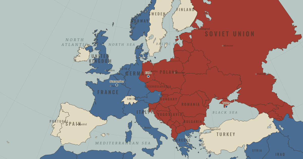
The map above is the world of 1945 — — An iron curtain descends.
BRIEF EXPLANATION — THE ESSENTIAL ARGUMENT
The shape of the postwar world was decided less by the peace conferences than by where the armies happened to stand when the fighting stopped. Soviet forces held much of Eastern Europe, where Soviet-backed governments soon took power, while the Western occupation zones grew into parliamentary democracies. Germany and Korea were each split along the lines the armies had reached, and the cooperation that had defeated the Axis quickly hardened into the rivalry of the Cold War.
The human cost was staggering, with about sixty million people killed, though the estimates vary widely, and many millions more uprooted from their homes. The war also accelerated the collapse of Europe’s colonial empires and gave rise to a set of new institutions, including the United Nations, war-crimes trials, the beginnings of international human-rights law, an economic order led by the United States, and the first steps toward European integration. These were deliberate attempts to manage the very problems the war had exposed, and they offered no guarantee against future violence.
GUIDED EXPLANATION
The final map is best read as a distribution of power rather than as a settled peace. Soviet armies occupied much of Eastern Europe while Western armies held the west, and although the agreements reached at Yalta and Potsdam mattered, it was military position that determined how those promises would actually be enforced. Germany was divided into occupation zones and later into two separate states, and Korea was split at the 38th parallel. The former allies now understood security in incompatible ways, because the Soviet Union sought controlled buffer states after suffering repeated invasion, while Western governments read that same control as naked expansion.
The human cost came to roughly sixty million dead, with the estimates varying by country and category, and the survivors faced displacement, famine, ruined cities, and redrawn borders. The Soviet Union lost about 27 million people and China perhaps around 20 million. New institutions answered specific failures of the prewar order, as the United Nations sought collective security, the Nuremberg trials established individual responsibility for state crimes, and the Genocide Convention and Universal Declaration of Human Rights set out legal standards, while Bretton Woods and the Marshall Plan underwrote economic recovery and European integration began to pool strategic industries. Colonial rule weakened as movements across Asia and Africa pressed claims that the imperial powers could no longer contain, so the legacy of the war was at once reconstruction and a new division of global power.
Every one of these settlements carried a tradeoff inside it. The United Nations Security Council granted the great powers a veto, because a system they refused to join would achieve nothing, yet that same veto could also paralyse action. Soviet buffer states answered a genuine history of invasion while denying political freedom to Germany’s neighbours, and American aid rebuilt Western Europe while binding it to a United States–led economy. Keeping the Japanese emperor eased the occupation but limited accountability at the very top. Decolonization widened sovereignty, though often through further war. None of these outcomes followed automatically from victory, because each emerged from the interplay of power, local movements, institutional design, and the memory of failure, which is why the final map is the starting point of the Cold War and the postwar world rather than a finished peace.
DEEP EXPLANATION — EVIDENCE & INTERPRETATION
Armies as political facts
The postwar conferences did not meet over an empty map, because occupation itself gave each great power the ability to shape the institutions, police, parties, and borders of the lands it held. Soviet security policy sought friendly or controlled states between Germany and the Soviet Union after two catastrophic invasions in thirty years, and Western leaders, while accepting some of these security claims, increasingly saw one-party governments as expansion. These competing logics produced a security dilemma, in which measures that one side called defensive looked offensive to the other. Germany’s occupation zones hardened into separate states, and the hurried division of Korea created another lasting frontier. This does not mean that every postwar outcome was fixed by May 1945, because elections, local communist and non-communist movements, economic recovery, and later crises all still mattered. It means that military position set the boundaries within which political choices were made, so the map records the balance of bargaining power and not merely the place where the fighting stopped.
Institutions and the unfinished peace
The postwar institutions were designed as deliberate answers to diagnosed failures of the old order. The United Nations combined universal membership with great-power vetoes, trading strict equality for the hope that the major powers would stay inside the system, while the Nuremberg trials prosecuted leading Nazis and developed the idea of crimes against humanity, even as critics called them victors’ justice. Human-rights instruments set standards without any automatic means of enforcement, the Marshall Plan funded recovery and tied Western European economies to the United States, and the pooling of coal and steel placed the material basis of Franco-German war under shared authority. At the same time, colonial powers tried to restore their empires, producing wars in Indonesia, Indochina, and elsewhere, so the promise of “never again” coexisted with nuclear arms, proxy wars, and later genocides. These institutions mattered because they reshaped expectations and law, and their non-obvious weakness was a dependence on states that were actually willing to apply them.
The WW2 atlas is free in full — no sign-up.
THE SITES
ON THIS DAY
WHY IT HAPPENED
Why the peace looked like this: armies are arguments. No conference redrew Europe — Yalta and Potsdam largely ratified where soldiers stood. Occupation zones became states; the 38th parallel became Korea; “facts on the ground” beat every principle. First rule of reading any postwar map: ask where the armies stopped.
Security through buffer. Invaded twice through Poland in 30 years at a cost of tens of millions, the USSR defined security as controlling everything between Berlin and Moscow. The West read the same control as expansion. Two rational security logics, zero trust: the Cold War in one sentence.
The productivity superpower. The US ended the war with half the world’s industrial output, the only intact great economy, the bomb, and the dollar (Bretton Woods, 1944) as the world’s money. American hegemony wasn’t declared; it was the arithmetic of 1945.
THE TURN
The handshake that became a border. Torgau, 25 April 1945: soldiers of two victorious armies grin for the cameras on a broken bridge. Within three years, the line where they met is fortified; within sixteen, a wall runs through Berlin. Alliances of necessity end when the necessity does.
WHAT IT CHANGED
The long peace — under a mushroom cloud. No great-power war since 1945: deterrence, exhaustion, institutions, or luck? Historians argue; all four probably. But the wars didn’t stop — they moved to the decolonizing world, fought by proxy, from Korea to Vietnam to Angola.
Never again — the unfinished project. Human-rights law, refugee conventions, genocide prevention: all direct answers to 1939–45, all tested and often failed since (Cambodia, Rwanda, Bosnia — the last on this very map). The war’s deepest lesson is not that evil was defeated once, but what it took, and how late everyone acted.
Your map, your questions. Switch to Free Explore mode: scrub the timeline, click any country, and trace one nation’s whole war — Poland’s erasure and shift westward, Finland’s three wars, Yugoslavia’s resistance, Spain’s watching neutrality. Every color change on this map is a hundred books. Pick one.
FIELD QUESTION — Was the Second World War “one war”? Argue both sides using what you’ve seen on this map.
For “separate wars,” China, Poland, Barbarossa, and the Pacific began with different dates, actors, and aims. For “one war,” December 1941 linked alliances, production, shipping, and strategy across theaters. Lend-Lease and synchronized offensives made outcomes interdependent. The strongest judgment is that several conflicts merged into one global system.
AN INTERESTING FACT
The war is still physically in the ground. German bomb-disposal services recover on the order of 2,000 tonnes of unexploded wartime ordnance every year, and evacuations for newly found bombs remain routine; in December 2011 some 45,000 people — nearly half of Koblenz — left home while engineers defused a 1.8-tonne British bomb exposed by the falling Rhine. The work still kills: three disposal technicians died at Göttingen in 2010, defusing a bomb dropped before any of them was born.
THE DISPATCH
One short letter when a new atlas opens — and the printable study guide for WW2 is yours now, free.
NO TRACKING · YOUR ADDRESS IS USED FOR THE DISPATCH AND NOTHING ELSE · UNSUBSCRIBE ANYTIME