MAPS OF HISTORY · Indian Independence & Partition · ALL CHAPTERS · CHAPTER 11
CHAPTER 11 · 1947 · AUG 1947
Freedom at Midnight
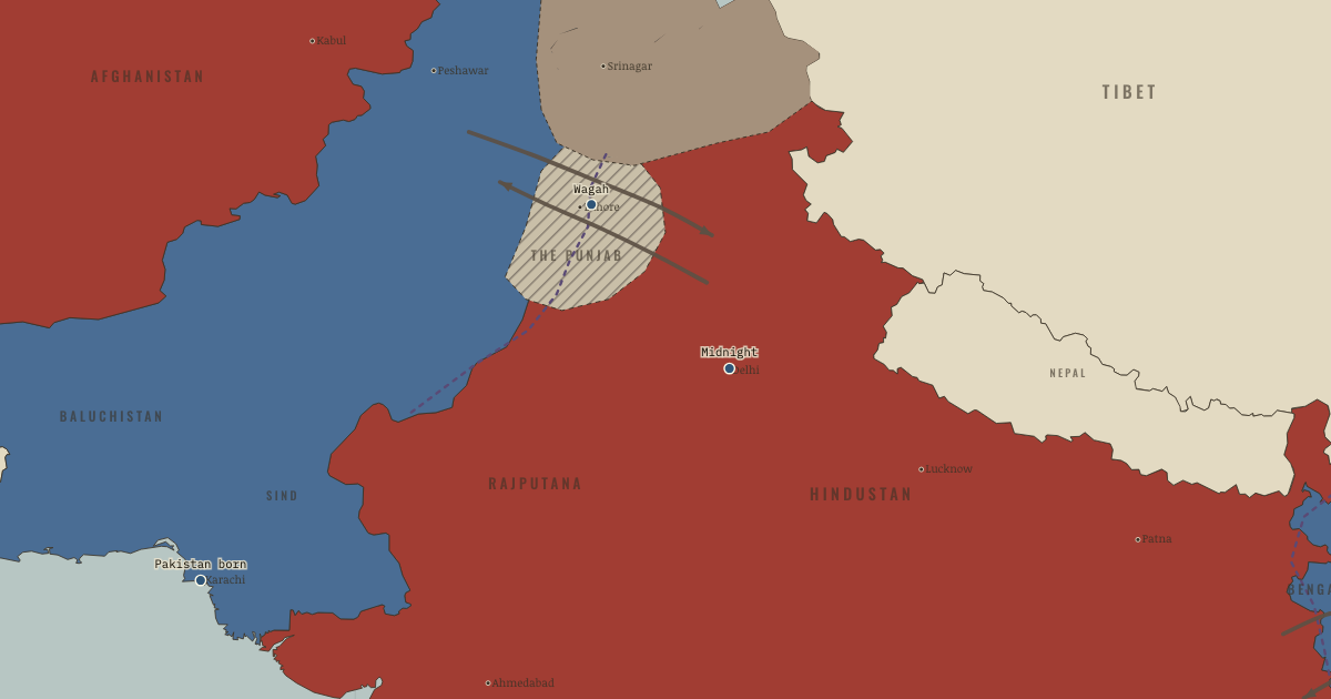
The map above is the world of AUG 1947 — Partition — two dominions.
BRIEF EXPLANATION — THE ESSENTIAL ARGUMENT
Independence and catastrophe arrived in the same August because the settlement that granted freedom was executed in far too little time. When Congress and the League could not agree on a workable centre, Mountbatten accepted partition and advanced the transfer of power to August 1947, leaving barely ten weeks. Two boundary commissions were given only weeks to divide Punjab and Bengal from incomplete census data, and the award was withheld until after the celebrations. India and Pakistan therefore became free before either knew its own final borders.
Freedom came amid one of the largest forced migrations in history. Across the new lines Hindus, Muslims and Sikhs fled or were driven out in both directions, and demobilized soldiers and organized bands turned flight into reciprocal ethnic clearance. Roughly ten to fifteen million people moved, and estimates of the dead range from about 200,000 to two million, because no reliable count was ever made. This atlas memorializes that violence rather than turning it into drama, because independence ended colonial rule while the rushed boundary and the collapse of security made freedom arrive beside mass killing, and both belong to the same month.
GUIDED EXPLANATION
Partition divided British India into two dominions, while the princely states followed a separate process of accession. The pace was set by Mountbatten, who arrived in March 1947 with a June 1948 deadline and broad powers, and who concluded within ten weeks that the interim government could not hold. Nehru and Patel accepted the division of Punjab and Bengal, and Jinnah accepted what he called a “moth-eaten Pakistan.” On 3 June Mountbatten advanced the transfer by ten months to 15 August, which left just seventy-three days. In that time Patel and V. P. Menon pressed the princely states, the tan patchwork covering two-fifths of the land, to accede, committees divided the army, treasury and services, and Cyril Radcliffe, a British barrister who had never set foot in India, was given five weeks and two boundary commissions to partition Punjab and Bengal. Such speed left almost no time for security, administration or public preparation.
The ceremonies and the catastrophe happened together. In Karachi on 14 August Jinnah became Governor-General, having already told Pakistan’s Constituent Assembly that religion should have “nothing to do with the business of the State.” In Delhi at midnight Nehru delivered his “tryst with destiny” speech, while Gandhi attended neither ceremony, since he was in Calcutta trying to stop communal violence. The Radcliffe Award was published two days after independence, so both states celebrated before knowing their borders. At Wagah on the Grand Trunk Road the new line ran between Lahore and Amritsar, only fifty kilometres apart, and across the Punjab Hindus, Muslims and Sikhs fled or were expelled in both directions while demobilized soldiers and organized bands turned riot into ethnic clearance. Roughly ten to fifteen million people moved, in one of history’s largest forced migrations, and estimates of the dead range from about 200,000 to two million, because no reliable total exists. This atlas treats the violence as memorial rather than spectacle: independence ended colonial rule, and the rushed boundary and broken security made freedom arrive beside mass displacement and killing, both outcomes of the same August.
DEEP EXPLANATION — EVIDENCE & INTERPRETATION
The uncountable dead, and why the number matters
The death toll of Partition is given here as a range, roughly 200,000 to two million, and the very width of that range is a historical fact worth dwelling on. No one counted. The killing happened as the colonial state dissolved and two new administrations struggled into existence, so there was no authority with either the capacity or the incentive to tally the dead, and both successor states had reasons to shape the figure. Demographers have since worked backward from the 1951 censuses, comparing expected with actual populations to estimate the missing, but the method cannot cleanly separate the killed from the migrated from the merely uncounted, and even the migration of ten to fifteen million people is only slightly more certain. Scholars such as Ravinder Kaur argue that this unknowability reflects the nature of the event, a catastrophe without a bookkeeper. This atlas states the range rather than choosing a number, because honesty about the uncertainty is part of the memorial, and a precise figure would be a false comfort. The truth is that a subcontinent lost track of how many of its own people it killed in the summer it became free.
Partition’s war on women, and the state that “recovered” them
Partition’s violence took a specifically gendered form that the political history long passed over in silence, and it is memorialized here because recovering it changed how the whole event is understood. Across the Punjab women were abducted, raped, and forcibly converted and married in the tens of thousands, and many were killed by the men of their own families, by fathers, husbands and brothers, in the name of preserving honour before the enemy could reach them, while some took their own lives for the same reason. The new states then compounded the wound. The Abducted Persons (Recovery and Restoration) Act of 1949 sent officials across the border to “recover” women and return them to their proper nation and religion, often against their own wishes and away from children and homes they had since made, treating the female body as national territory to be repatriated. For decades this history existed only as silence, until oral historians such as Urvashi Butalia, Ritu Menon and Kamla Bhasin sat with survivors and recorded it. Their work is the evidence, and its lesson is that a national tragedy told only through its statesmen and its borders leaves out the very people on whom those borders were carved.
New here? Chapters 1–2 of every atlas are free to sample, and the WW2 atlas is free in full. One membership opens all thirteen — the Cartographer’s Circle.
THE SITES
ON THIS DAY
WHY IT HAPPENED
The seventy-three-day timetable. Mountbatten’s defenders argue the Punjab proved the state was dissolving and delay meant civil war with a mutinying army. His critics answer that the advance from June 1948 to August 1947 tore up every administrative preparation — the Punjab Boundary Force was 50,000 men for a province of 34 million. It converted a managed transfer into a race. The record shows both: Wavell’s breakdown papers forecast collapse, and the speed demonstrably outran the security plan, because there was none. What no one disputes is whose convenience the date served: Britain left before the bill, and the bill was paid in Punjabi.
Radcliffe’s five weeks. Two commissions, deadlocked lawyers, census tables from 1941, no time for surveys, and a chairman who had never seen the rivers he was dividing: the award was an honest man’s best guess executed as national surgery. Radcliffe cut canal systems from their headworks, factories from their hinterlands, shrines from their pilgrims — not from malice but because no line existed that did not. He understood what he had done: he destroyed his papers, took no fee, and never returned to either country. The deeper cause was not the drawer but the commission: a border demanded in weeks that decades of politics had refused to imagine in detail.
The princely stampede. Paramountcy lapsed with the Raj — legally, 565 states became sovereign on 15 August. Patel and Menon, wielding the Instrument of Accession (defence, foreign affairs, communications only — the rest negotiable later) and the plain fact of geography, gathered all but three before the deadline: an administrative feat as consequential as the transfer itself, and the reason this map’s tan patchwork dissolves into the two dominions rather than into a hundred Balkans. The three holdouts — Junagadh, Hyderabad, Kashmir — are the next chapter’s wars.
Why the Punjab, worst of all. Bengal’s partition, for all its pain, killed thousands. The Punjab’s killed hundreds of thousands. The difference was structural: a three-way division (Muslim, Hindu, Sikh — the Sikhs’ homeland and holiest places straddling any possible line), two million demobilized soldiers, a canal-colony prosperity worth fighting for, and a spring of massacres (March 1947, Rawalpindi) that had already militarized every village. Partition in the Punjab was not a migration that turned violent. It was a war of position over where the line’s facts would lie.
THE TURN
The award published, 17 August 1947. Two days after the flags rose, the line appeared. Fifteen million people discovered which side of it their homes were on. The hinge of the chapter is this gap: freedom was celebrated by nations that did not yet know their own shape, and when the shape came, it came as a casualty list. At Wagah the Grand Trunk Road — the artery of northern India for four centuries — acquired a gate, and the gate a ceremony, and the ceremony (lowered flags, competitive goose-steps, roaring crowds) continues every sunset as the era’s strangest monument: the theatre of a wound, performed nightly, by both its heirs.
WHAT IT CHANGED
Two states built from one civil service. The division of assets ran from sterling balances (Pakistan’s share withheld, then released under Gandhi’s last fast) to army regiments split by religion to library sets divided alternate-volume. Pakistan began with 17% of the revenue base, one working port, and a capital in a city it had to borrow. India inherited the centre and its institutions. The asymmetry of 1947 is the substrate of every Indo-Pakistani crisis since.
The refugees remake both nations. Delhi and Karachi became refugee cities within a year — Karachi’s population doubled. Delhi absorbed a Punjabi migration that changed its language and politics. The camps’ generation carried the border inside them: the memory politics of both states. The memory politics of Bangladesh after 1971 — descends from these columns. Fifteen million uprootings do not settle. They compound.
A line that never closed. The Radcliffe award left the two new states contesting canal headworks within months (the waters dispute ran until the 1960 Indus Treaty) and Kashmir within weeks — the one princely accession where geography, demography and the two national theories collided head-on. The next chapter opens with that war already burning.
FIELD QUESTION — Mountbatten advanced independence by ten months. Weigh the decision: did speed avert a greater catastrophe, or cause the one that happened?
Assemble the strongest case for each side, because both exist. For speed: by spring 1947 the interim government had ceased functioning, the Punjab ministry had fallen with nothing to replace it, the army’s communal reliability was visibly eroding (the INA fervor and RIN mutiny fresh), and Wavell’s own planning had reached evacuation schemes — on this reading Britain was not choosing between orderly and hasty transfer but between hasty transfer and disintegration without an address for power. Against speed: the date was set before the boundary, the force, or the refugee plan existed. The Punjab Boundary Force amounted to one soldier per square mile of the most armed province in Asia. Publication of the award was held until after the ceremonies for political tidiness. And the ten months surrendered were precisely the months in which population exchange could have been organized rather than suffered. The most defensible verdict is asymmetric: some catastrophe was probably unavoidable by 1947 — the Punjab was armed and the trust was gone. But its scale was a variable, not a constant, and the variable was administered. Speed did not invent the knife. It removed everything that might have stood between the knife and fifteen million people. Note, finally, who is absent from the calculation on both sides: no Indian or Pakistani signature is on the date. The last great decision of the Raj was, like the first, taken for India rather than by her.
AN INTERESTING FACT
Cyril Radcliffe was chosen because his ignorance of India was considered a qualification — impartiality by innocence. He worked in a bungalow on the viceregal estate from maps and the 1941 census, never visiting the border districts (his one flight over the Punjab was cut short by heat and time); he finished the two awards in five weeks, watched the first reports of the killing, burned his working papers, declined his 3,000-guinea fee, and left India on 15 August itself, never to return. Auden’s poem “Partition” fixed him in literature — “in seven weeks it was done, the frontiers decided” — a shy, scrupulous lawyer who is remembered by a line on the earth that he, alone among its authors, refused to be paid for.
THE DISPATCH
One short letter when a new atlas opens — and the printable study guide for Indian Independence & Partition is yours now, free.
NO TRACKING · YOUR ADDRESS IS USED FOR THE DISPATCH AND NOTHING ELSE · UNSUBSCRIBE ANYTIME