MAPS OF HISTORY · Indian Independence & Partition · ALL CHAPTERS · CHAPTER 12
CHAPTER 12 · 1947–1949 · FEB 1948
The Price and the Legacy
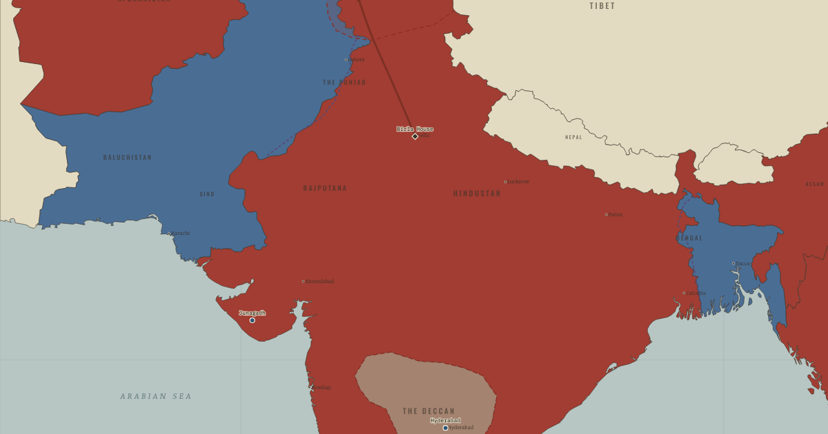
The map above is the world of FEB 1948 — Burma & Ceylon go free.
BRIEF EXPLANATION — THE ESSENTIAL ARGUMENT
Independence did not end the era’s violence so much as bequeath it to the new states, which struggled at once to absorb refugees and to establish their own authority. Gandhi spent his last months fasting to halt communal reprisals and to press India into paying Pakistan the money it was owed. On 30 January 1948 a Hindu nationalist assassinated him, and the murder exposed how dangerous majoritarian nationalism had become inside the new republic itself. His killing briefly discredited that politics and made him the founding martyr of the Indian state.
The princely states had still to choose their future, and most acceded to one dominion or the other through negotiation. Junagadh, Hyderabad and Kashmir each produced a crisis by a different mechanism, and Kashmir’s remains unsettled to this day. Burma and Ceylon left the empire by their own separate routes, one outside the Commonwealth after an assassination and one by peaceful negotiation. Independence ended British paramountcy across the subcontinent, yet it settled neither every border nor every identity nor every claim that colonial rule had created.
GUIDED EXPLANATION
Accession was the legal act by which a princely ruler joined one dominion, handing over a defined set of powers, and after independence three of these states remained unresolved. Junagadh had a Muslim ruler and a Hindu-majority population, and when its nawab acceded to distant Pakistan, India blockaded the state, the nawab fled to Karachi, and a later plebiscite confirmed Indian control. Hyderabad, the largest princely state, held out for independence until Indian troops ended the standoff in five days in September 1948, after which communal killings followed that an official inquiry put in the tens of thousands. Kashmir had a Hindu maharaja, a Muslim-majority population and borders with both dominions. In October 1947 a tribal lashkar from the frontier, armed and led in part by Pakistani officers, advanced on Srinagar, and its sack of Baramulla delayed it just long enough for Hari Singh to sign the Instrument of Accession to India and for Indian troops to land. Fourteen months of war ended with a UN-brokered ceasefire on 1 January 1949, a line that divided Kashmir while settling neither its sovereignty nor the rival principles of accession and popular will.
The era closed with an assassination that measured how far its own violence had spread. On 30 January 1948, at Birla House in Delhi, Nathuram Godse shot Mohandas Gandhi, whom he blamed for favouring Muslims and Pakistan, and Nehru told the radio audience that “the light has gone out of our lives.” The killing briefly discredited militant majoritarian politics and made Gandhi a founding martyr of the republic. Other exits from empire offered instructive comparisons. Burma became independent outside the Commonwealth in January 1948, after the assassination of Aung San, while Ceylon gained freedom by negotiation in February without partition. Its later ethnic conflict showed that even a peaceful transfer had not dissolved the underlying disputes of identity. The tide chart of self-rule stays flat for decades and then rises sharply, because formal freedom arrived quickly at the end of a long struggle. Its achievements and its costs have to be held together. Around fifteen million people crossed Partition’s lines, and perhaps 200,000 to two million died. Some four hundred million people ceased to be colonial subjects, while India and Pakistan began statehood divided by refugees, violence and an unsettled ceasefire line.
DEEP EXPLANATION — EVIDENCE & INTERPRETATION
Hyderabad: the integration that hid an atrocity
The absorption of Hyderabad in September 1948, the Indian army’s five-day “Operation Polo” that ended the largest princely state’s bid for independence, is usually filed as the triumphant last act of national integration. Beneath it lies a memorial the new state worked hard to bury. As the army moved in, and in the weeks that followed, mass killings of Hyderabadi Muslims took place, in part as reprisal for the abuses of the Razakar militia that had terrorized Hindus beforehand. Nehru, disturbed by the reports, commissioned an inquiry led by the Gandhian Sunderlal, whose findings, estimating deaths plausibly in the tens of thousands, were judged so damaging that the report was suppressed and not officially released until 2013, sixty-five years later. The episode is a discipline against triumphalism. The same operation this map records as the tidy dissolution of a tan patchwork into Indian red was, on the ground, another of the era’s communal massacres, committed this time under the new republic’s own flag. A nation’s founding story keeps the integration and edits out the reprisal, and the historian’s task, like this atlas’s, is to hold both at once.
The world’s largest experiment, and what it taught
The freedom won on this map was watched by half the colonized world, and its afterlife runs in two directions the atlas asks you to hold together. As a demonstration, the peaceful transfer of the largest colony in history made the continuation of European empire elsewhere look impossible as well as immoral, and the floodgates opened, with Ceylon and Burma free within a year and most of Asia and Africa within a generation. As a method, Gandhian non-violent mass action became the twentieth century’s most exported political technique, studied and adapted by Martin Luther King, who travelled to India in 1959 and called Gandhi “the guiding light,” by the anti-apartheid movement of Mandela, and by the later risings known as people power. The warning travelled just as far. Partition became a template too, the idea that a plural society could be surgically divided along religious or ethnic lines, and it recurred from Palestine to Cyprus to Ireland, usually with the same afterlife of contested borders and displaced millions. India’s twentieth century teaches that mobilized mass politics can free a fifth of humanity without a war of independence, and that the same mobilized identities, once summoned, can outrun every leader who called them. This atlas insists on teaching both lessons, because the century that learned only the first paid dearly for the second.
New here? Chapters 1–2 of every atlas are free to sample, and the WW2 atlas is free in full. One membership opens all thirteen — the Cartographer’s Circle.
THE SITES
ON THIS DAY
WHY IT HAPPENED
Three holdouts, one doctrine. Paramountcy’s lapse left accession to the rulers, not the ruled — so Junagadh’s nawab, Hyderabad’s nizam and Kashmir’s maharaja each chose against their subjects’ apparent majority, and each choice detonated. India argued popular will in Junagadh and legal accession in Kashmir. Pakistan argued the mirror image. Both were arguing interest dressed as principle, as new states do. The deeper cause is chapter 1’s: a legal fiction (princely sovereignty under the Crown) preserved for a century as imperial convenience, cashed out in ten weeks as three crises.
Kashmir: geography against theory. A Muslim-majority state, contiguous with both dominions, ruled by a Hindu dynasty, with a nationalist movement (Sheikh Abdullah’s National Conference) closer to Nehru than to Jinnah: Kashmir falsified both national theories at once, which is why neither could let it go. The lashkar forced the accession it was meant to prevent. The airlift saved a capital and inherited a dispute. The UN ceasefire froze rather than settled it. Wars that end in lines rather than answers are the ones that return.
The assassination’s politics. Godse was not a madman but a doctrine — the militant Hindu-nationalist reading in which Gandhi’s non-violence had emasculated Hindus and his fasts served Pakistan. The murder discredited that politics for a generation (the RSS banned, then unbanned. Its long reconstruction is another era’s story) and fixed the martyrdom at the republic’s foundation: the state’s first great trial was of its founder’s killer. Both facts shaped what India would and would not permit itself for decades.
Why Ceylon and Burma exited differently. Ceylon reached 1948 with universal suffrage since 1931, elite politics unbroken by mass jailings, no Congress-scale movement to suppress and no communal architecture of separate electorates — so the transfer was a negotiation between gentlemen, with the ethnic reckoning deferred (Tamil disenfranchisement began within a year. The deferred bill came due for decades after 1983). Burma, separated in 1937 and shattered by war and occupation, had an armed nationalist movement and no reason to trust the Commonwealth. The comparison isolates the variables: mass mobilization won India freedom faster and at higher communal temperature. Institutional continuity bought Ceylon calm and postponed, not escaped, the identity question.
THE TURN
Birla House, 30 January 1948. Three shots at a prayer meeting, and the era acquires its full and final shape: the movement’s founder killed not by the empire he defeated but by a son of the nation he made, for the crime of insisting both new nations belonged to all their citizens. The turn is the era’s verdict on itself — freedom won by discipline of soul, immediately tested by the fury the winning had unleashed, and the founder’s body the test’s first exhibit. What held afterwards (a secular constitution, written under Ambedkar’s chairmanship, adopted within two years) and what did not (Kashmir, the neighbourhood’s peace) were both settled in the shadow of this garden. Remember him. And remember that his last fast, days before, had been against his own government, for Pakistan’s money. That is the standard the era set, and mostly failed, and never forgot.
WHAT IT CHANGED
Two constitutions from one struggle. India’s constituent assembly, its drafting committee chaired by Ambedkar — the Poona Pact’s wounded party now the framer — produced in 1950 a secular, universal-franchise republic that made the 1935 Act’s chassis carry a democracy. Pakistan’s path was harder: Jinnah dead within thirteen months of the state he made, the mission statement of his 11 August speech contested ever since, the first constitution nine years coming. The divergence of the two states’ institutional stories begins in the founders’ first two years.
The ceasefire line becomes a fault line. The 1949 line (renamed the Line of Control in 1972) froze the first war into a permanent geography: three more wars and a nuclear standoff have run along it. On this atlas it is the last mark drawn — the era’s unfinished sentence, and the direct inheritance of a five-week boundary, a lapsed paramountcy and a ruler’s dithering autumn.
The freedom itself. Do not let the catastrophe swallow the achievement, for the sources never did: the largest colonized population in history freed itself substantially by non-violent mass action — a method invented, argued and exported from this map. Against every colonial-era prediction, the Indian republic’s universal-franchise democracy held. The era’s exports run from Martin Luther King’s Montgomery to Mandela’s reconciliations. Its warning — that mobilized identity can outrun every leader’s intent — runs just as far. This map teaches both or it teaches nothing.
FIELD QUESTION — Fifteen million displaced, hundreds of thousands to two million dead — and four hundred million freed. Was Partition the price of freedom, or a separate catastrophe that freedom’s mismanagement allowed?
Keep the two ledgers distinct before relating them, because collapsing them is how each nationalism cheats. Freedom’s ledger: won primarily by two generations of Indian mass politics — satyagraha, election, sacrifice — with the war as accelerant. By 1945 British withdrawal was certain and no serious historian credits Partition as its price. Partition’s ledger: contingent at many points — separate electorates in 1909, the coalition refusal of 1937, the war’s patronage of the League, the Mission’s failure in 1946, the timetable of 1947 — each an exit not taken. The violence’s scale, further, was administered rather than fated (compare the Punjab’s war to Bengal’s terrible but smaller agony, and both to Ceylon’s peace). So the defensible answer: freedom did not require Partition, but the specific road India travelled — communal architecture plus majoritarian anxiety plus a departing empire’s haste — made some partition probable by 1946 and the catastrophe’s magnitude a matter of choices, mostly bad, mostly hurried. What the question finally teaches is about political time: the forty-year struggle built a nation slowly and well. The last seventy-three days demolished an empire quickly and terribly. Institutions and trust are built at one speed and destroyed at another, and the gap between those speeds — measured in this atlas’s tide chart as a cliff — is where the dead of 1947 lie.
AN INTERESTING FACT
The constitution free India adopted on 26 January 1950 — the date chosen to honour the purna swaraj pledge of 1930 — was drafted by a committee chaired by Dr B. R. Ambedkar, the Dalit leader whom Gandhi’s Poona fast had cornered eighteen years earlier: the man the old order had made untouchable wrote the document that outlawed untouchability (Article 17). It is the longest written constitution of any sovereign state, its original calligraphed by Prem Behari Narain Raizada and illuminated by Nandalal Bose’s artists with scenes from the subcontinent’s whole past — Mohenjo-daro to the Mughals to Gandhi’s march — so that the book itself argues what this atlas argues: the new republic claimed the entire map, and every century on it, as inheritance.
THE DISPATCH
One short letter when a new atlas opens — and the printable study guide for Indian Independence & Partition is yours now, free.
NO TRACKING · YOUR ADDRESS IS USED FOR THE DISPATCH AND NOTHING ELSE · UNSUBSCRIBE ANYTIME