Indian independence · OCT 1905
Why is Bengal’s 1905 partition seen as the road to 1947?
The seminar question: “The partition of Bengal was annulled — the agitation won. Why do historians still treat 1905 as the beginning of the road to 1947 rather than a nationalist victory story?”
In October 1905 Lord Curzon divided Bengal, a province of 78 million people, creating a Muslim-majority eastern province governed from Dacca. Bengalis answered with the Swadeshi boycott of British goods, the All-India Muslim League was founded at Dacca in 1906, and the partition was annulled in 1911.
Chapter 4 is part of membership. WW2 is free — every chapter. Try chapters 1–2 of any 2 other atlases (3 with a free account). Opening a new atlas uses one of them. Membership opens all 21 — Join.
Free printable Indian independence study guide, sent by email ↓
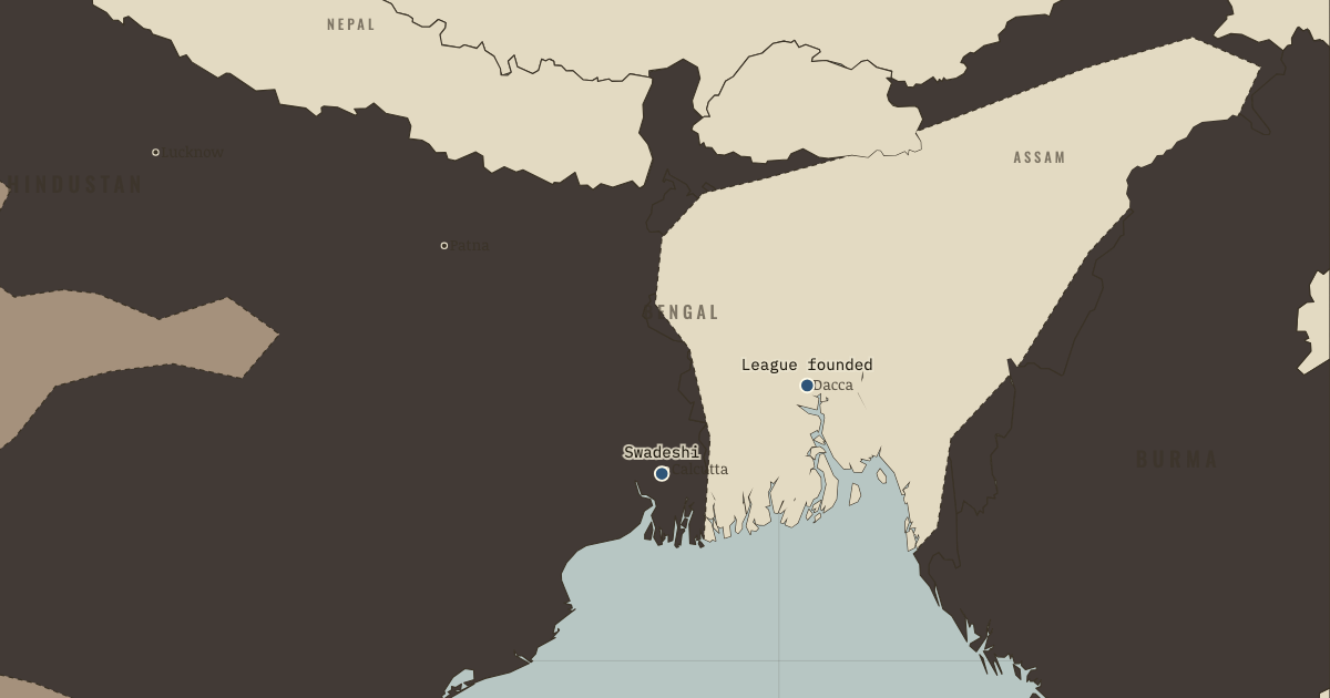
Curzon’s reform carried a political edge that its administrative logic could not hide. In October 1905 he divided Bengal, the Raj’s most populous province, into a western half around Calcutta and a new eastern province of Eastern Bengal and Assam governed from Dacca. The practical case was real, since one lieutenant-governor could not run 78 million people, but his officials recorded the political advantage plainly. “Bengal united is a power,” one minuted, “Bengal divided will pull several different ways.” The new province gave Muslims a majority and Dacca a capital, while the old one left Bengali speakers outnumbered by Biharis and Oriyas. Bengalis of both faiths read the redrawing as vivisection, and their reaction created the repertoire that Indian nationalism would use for the next forty years. Under the banner of Swadeshi, meaning reliance on goods made in one’s own country, they burned Manchester cloth, founded national schools and banks, and tied rakhi threads across Hindu and Muslim wrists in Tagore’s processions. The age of polite petitioning ended in a single autumn.
The short answer
- An administrative logic with a political edge. Bengal genuinely was ungovernable as one unit. But the chosen line was one of several available, and officials candidly recorded its advantage: it split the Bengali-speaking intelligentsia who led nationalist agitation, and cultivated East Bengal’s Muslim majority as a counterweight. Divide-and-rule was not the whole story. It was, demonstrably, part of the file. The partition taught Indian politicians that administrative maps were political weapons — a lesson both Congress and the League remembered.
- Swadeshi: the economy as battlefield. The boycott hit where empire lived — the textile trade. Imports of British cloth into Bengal fell by a quarter in a year. Bombay and Ahmedabad mills boomed on the demand. Swadeshi fused economic nationalism (Naoroji’s Drain made flesh) with religious symbol and street theatre, and proved a colonized society could hurt the metropole without a single rifle. Gandhi, then in South Africa, studied it closely. Non-Cooperation is Swadeshi generalized.
- Muslim anxiety was real, not manufactured. It suits a simple story to call the League a British puppet, and separate electorates were indeed a Raj gift. But the anxiety beneath was authentic: Muslims were a quarter of India, poorer, under-represented in the universities and the professions, and the Swadeshi movement’s Hindu idioms — Kali oaths, Bande Mataram — told many Bengali Muslims this awakening was not entirely theirs. The tragedy of 1905–09 is that both perceptions were reasonable, and the institutions built on them (separate electorates above all) made them permanent.
- Congress splits over method. Surat 1907 posed the era’s recurring question: petition or pressure? The Moderates (Gokhale) feared losing the reforms on offer. The Extremists (Tilak — “Swaraj is my birthright, and I shall have it”) argued only agitation ever produced reforms at all. The Raj settled the argument by jailing Tilak for six years, which proved his point. Every later split — Gandhi vs the Swarajists, Congress vs Bose — replays Surat with higher stakes.
THE TURNING POINT
16 October 1905 — the day of the partition. The day the partition takes legal effect, Bengal declares mourning: shops shut, hearths cold, the Kali temple thronged, and Tagore leads processions in which Hindus and Muslims tie rakhi on each other’s wrists. It is the first time the nation is performed in the street rather than petitioned in a hall. It works: within six years the Raj retreats for the first time in its history. The turn is double-edged, which is why it is the hinge: the same six years that prove mass pressure works also found the Muslim League and write separate electorates into law. Both 1947 states are, in embryo, present in this one autumn.
What it changed
The Raj learns retreat is possible — and so does India. The 1911 annulment was meant to buy quiet. Instead it set the precedent every later campaign invoked: sustained agitation moves London. A government that had never once reversed a major decision under Indian pressure had now done so. The mystique of imperial finality never recovered.
Separate electorates: the wall in the foundation. Morley–Minto’s separate electorates (1909) meant Muslim politicians henceforth answered only Muslim voters — moderation toward the other community won no votes, escalation cost none. Constitutionalists defended it as minority protection. In the long run it made communal identity the currency of politics. Nearly every historian of Partition, whatever else they argue, marks this as load-bearing.
Delhi, the imperial capital — briefly. Moving the capital to Delhi in 1911 (announced by George V in person at his own durbar) was retreat dressed as grandeur: away from Bengal’s agitation, toward the Mughal throne’s symbolism. Lutyens’ New Delhi took twenty years to build. The Raj got to use it for sixteen. The empire built its most magnificent capital for its successor state.
The full answer, argued
Because everything that made 1947 possible acquired institutional form in these six years. The mass boycott proved the Raj was coercible. But its Hindu devotional idiom showed how easily “the nation” could speak in one community’s voice. Muslim anxiety acquired an organization (the League, 1906) and, fatally, an electoral architecture (separate electorates, 1909) that rewarded communal solidarity and punished cross-communal appeal for the next four decades. And the Raj learned to manage nationalism by conceding form while relocating substance — annul the partition, move the capital. Weigh the ledger: the agitation won a boundary back. The era wrote communal separation into the constitutional foundations. A victory in the streets, and in the statute book a defeat whose size no one yet measured — that is why 1905 opens this atlas rather than decorating it.
An interesting fact
Two national anthems were born in this one agitation. Tagore wrote “Amar Shonar Bangla” — “My Golden Bengal” — in 1905 to mourn the partition; sixty-six years later it became the national anthem of Bangladesh, a state whose borders are nearly Curzon’s eastern province. And “Jana Gana Mana,” which he wrote in 1911, is India’s. The same poet, the same six years, the anthems of two countries this map will create — Tagore, who renounced his knighthood over Amritsar in 1919, remains the only person to have authored the anthems of two sovereign states.
This is the study layer of Partition of Bengal and Swadeshi, chapter 4 of Indian Independence & Partition, 1857–1964; the full index of the atlas is here.
Related questions
THE FREE PRINTABLE STUDY GUIDE
Join the Dispatch — a short welcome series, then a letter when a new atlas opens — and the printable study guide for Indian Independence & Partition is yours now, free.
NO TRACKING · YOUR ADDRESS IS USED FOR THE DISPATCH AND NOTHING ELSE · UNSUBSCRIBE ANYTIME