ON THIS DAY ·
Potsdam Conference
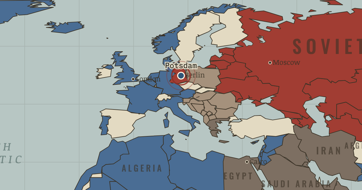
17 Jul–2 Aug 1945 — The victors divide Germany into occupation zones. Mid-conference Truman learns the bomb test worked, and mentions “a new weapon” to Stalin — who already knows.
WW2 is free — every chapter. Try chapters 1–2 of any 2 other atlases (3 with a free account). Opening a new atlas uses one of them. Membership opens all 21 — Join.
The moment in context
The colours on the 1945 map were drawn by armies rather than by any peace conference, and that fact shaped everything that followed. Soviet forces held the ground they had reached in central Europe, Western forces held what they had taken from the opposite direction, and the empires of Britain, France and the rest still coloured much of Asia and Africa. The most dangerous feature of the settlement was Berlin, the German capital, which lay deep inside the Soviet occupation zone yet was itself divided among the victors. Because the Western sectors could be supplied only across Soviet-held territory, the city became a place where either side could apply pressure without having to fire a shot.
From Origins of the Cold War, chapter 1 of The Cold War, 1945–1991 (MAR 1946).
The place: Potsdam Conference — map and full story →
Teach this in 5 minutes
- Why it happened — The security dilemma — two rational fears. The USSR, invaded twice through Poland in thirty years at a cost of 27 million dead, defined security as controlling everything between Berlin and…
- The turn — Moscow, 22 February 1946. Asked routinely why Moscow opposed the World Bank, George Kennan answers with 5,000 words: Soviet hostility flows from internal needs, not Western…
- What it changed — Containment becomes policy. Kennan’s idea gets money and muscle within eighteen months: aid to Greece and Turkey, the Marshall Plan, then NATO. The doctrine’s author will spend…
Then ask the room: Was the Cold War inevitable in 1945 — or the product of avoidable choices? The argued answer is on the chapter page →
The atlas that shows it
THE FREE PRINTABLE STUDY GUIDE
Join the Dispatch — a short welcome series, then a letter when a new atlas opens — and the printable study guide for The Cold War is yours now, free.
NO TRACKING · YOUR ADDRESS IS USED FOR THE DISPATCH AND NOTHING ELSE · UNSUBSCRIBE ANYTIME