ONE LAND · 14 ATLASES
History of Israel in maps
Israel as it appears in 14 interactive history atlases, from 264 BC to 2015: Judaea, the Latin Kingdom’s heart, Palestine & the Crusader coast, Israel, Palestine, Palestine / Israel. Each era below lists who ruled the land and when control changed, linked to the dated map that shows it.
WW2 is free — every chapter. Try chapters 1–2 of any 2 other atlases (3 with a free account). Opening a new atlas uses one of them. Membership opens all 21 — Join.
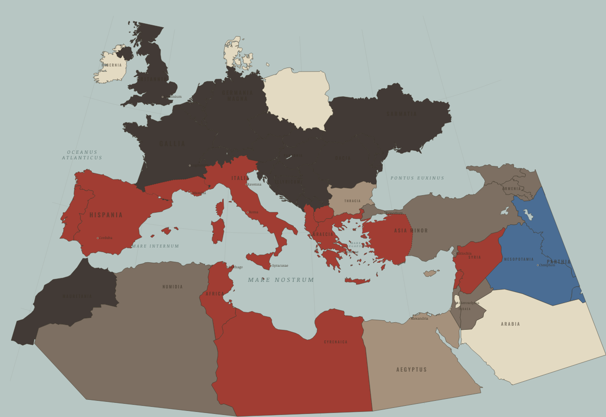
What was Israel before it was Israel? Below, every era of this land in the Maps of History atlases — who ruled it, what it was called, and when control changed — each line linked to the dated map that shows it. Modern borders stand in as an honest approximation; every atlas says so on the map itself.
Judaea (mod. Israel) · Ancient Rome
Judaea: client kingdom under Herod, province from AD 6, and the empire’s most determined resister. The revolt of 66–73 ended with the Temple destroyed (the ◆ marker at Jerusalem); Bar Kokhba’s rising in 132–135 ended with Judaea depopulated and renamed. Two world religions carry this province’s Roman history in their bones.
| 264 BC | Hellenistic kingdoms — the opening position |
| 62 BC | Roman clients & allies |
| Roman territory | |
| Breakaway Roman empires (260–274) | |
| Roman territory |
ANCIENT ROME: EVERY CHAPTER AND MAP →
The Latin Kingdom’s heart (mod. Israel/Palestine) · Crusades
The heart of the Kingdom of Jerusalem — Jerusalem, Acre, Ascalon, Jaffa. Taken in the massacre of 1099, lost after Hattin in 1187, briefly regained by Frederick II’s treaty in 1229, and gone for good by 1244. Throughout, a Frankish minority ruled over a mixed population of Muslims, Jews, Samaritans and Eastern Christians who remember that century very differently from one another.
| The Islamic powers — Seljuk, Zengid, Ayyubid, Mamluk — the opening position |
CRUSADES: EVERY CHAPTER AND MAP →
Palestine & the Crusader coast (mod. Israel) · Mongol Empire
| The Islamic powers — the opening position |
MONGOL EMPIRE: EVERY CHAPTER AND MAP →
Israel · Industrial Revolution
| Opened by force or treaty — the opening position | |
| Opened by force or treaty |
INDUSTRIAL REVOLUTION: EVERY CHAPTER AND MAP →
Israel · Age of Revolutions
| Neutral / uncommitted — the opening position |
AGE OF REVOLUTIONS: EVERY CHAPTER AND MAP →
Israel · Meiji Japan and post-Soviet Russia
| Western powers and allies — the opening position |
MEIJI JAPAN AND POST-SOVIET RUSSIA: EVERY CHAPTER AND MAP →
Palestine (Ottoman Empire) · WWI
Israel · Stalin’s Soviet Union
STALIN’S SOVIET UNION: EVERY CHAPTER AND MAP →
Israel · Road to WW2
| Colonial empires & possessions — the opening position |
ROAD TO WW2: EVERY CHAPTER AND MAP →
Israel · WW2
| Western Allies — the opening position |
Israel · Cold War
Founded 1948 in the shadow of the Holocaust and immediately a Cold War variable: armed first by Czech-brokered deals and France, later by America. Its 1967 victory redrew the region; 1973 nearly redrew it back and put both superpowers on nuclear alert (Ch. 8). The US–Israel alignment the era forged outlived the era.
| NATO & core Western allies — the opening position | |
| US-aligned states | |
| US-aligned states |
COLD WAR: EVERY CHAPTER AND MAP →
Israel · Decolonization of Africa
| Independent before 1945 — the opening position |
DECOLONIZATION OF AFRICA: EVERY CHAPTER AND MAP →
Israel · Feminism and the Tunisian Revolution
| Authoritarian, one-party or colonial rule — the opening position | |
| Right won in law | |
| No reform yet / outside this story | |
| Partial or unequal; treaty signed only; transition |
FEMINISM AND THE TUNISIAN REVOLUTION: EVERY CHAPTER AND MAP →
Palestine / Israel · Refugee crises
Mandatory Palestine became the destination the Jewish DPs demanded, and Britain’s limits on entry produced the clandestine ships, the Exodus affair and the camps on Cyprus. After the State of Israel was proclaimed in May 1948, it admitted the remaining Jewish DPs, about 132,000 of them with IRO help, alongside hundreds of thousands of Jews from the Middle East. The same war displaced 700,000 to 750,000 Palestinians.
| Western bloc or democracy — the opening position | |
| Neutral or between the blocs |
REFUGEE CRISES: EVERY CHAPTER AND MAP →
Related
THE FREE PRINTABLE STUDY GUIDE
Join the Dispatch — a short welcome series, then a letter when a new atlas opens — and a printable atlas study guide of your choice is yours now, free.
NO TRACKING · YOUR ADDRESS IS USED FOR THE DISPATCH AND NOTHING ELSE · UNSUBSCRIBE ANYTIME