Norse and Aztecs · CHAPTER 7 ·
Founding of Tenochtitlan
Chapter 7 of Climate and Innovation: The Norse and the Aztecs, c. 790–1521: “An Empire Built on a Lake”
Tradition places the founding of Tenochtitlan in 1325, when the Mexica settled in a lake in the Basin of Mexico, a high valley at about 2,240 metres with no outlet, where salty Lake Texcoco met fresh southern lakes. Their century serving Azcapotzalco ended with its fall in 1428 and a Triple Alliance formed to share tribute.
Chapter 7 is part of membership. WW2 is free — every chapter. Try chapters 1–2 of any 2 other atlases (3 with a free account). Opening a new atlas uses one of them. Membership opens all 21 — Join.
Free printable Norse and Aztecs study guide, sent by email ↓
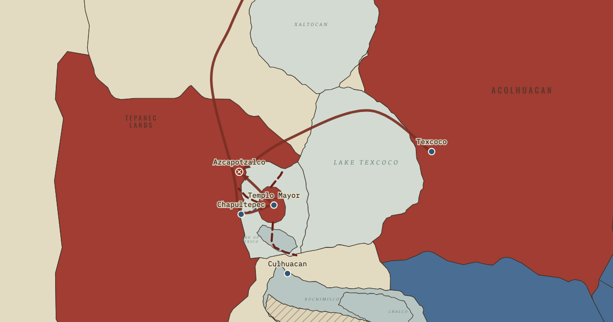
The map above is the world of The Basin of Mexico, 1428 — The Tepanec War and the Triple Alliance.
Part of IB History: The Norse and the Aztecs →
BRIEF EXPLANATION — THE ESSENTIAL ARGUMENT
The second case begins with a people who chose to settle in the middle of a lake, and the choice explains both the strengths and the weaknesses of everything they later built. The Basin of Mexico is a high valley at about 2,240 metres, ringed by mountains and with no natural outlet, so the summer rains collected in a chain of shallow lakes covering perhaps 1,000–1,500 square kilometres at high water. Lake Texcoco, the lowest, was salty, because water flowed in and left only by evaporation, the way salt builds up in a pan of boiling water, while the spring-fed southern lakes of Xochimilco and Chalco were fresh. Frost could kill maize at that height, and the rains could fail or flood. On the map, pale water marks salt and blue-grey water marks fresh. Whoever settled in this basin would have to live with too little water in some years and too much in others.
The Mexica, the people later called the Aztecs, arrived late, as migrants from the north who served stronger neighbours as soldiers and paid them tribute, regular payments in goods owed by the weak to the strong, much like a tax, and around 1325 they founded Tenochtitlan on marshy islands in the western lake. The lake gave them protection, fish and birds to eat, and a highway for canoes in a land without draught animals, but no fresh water on the island and a constant risk of flood. For a century they were vassals of the Tepanec kingdom of Azcapotzalco, shown in charcoal. In 1428 they joined Nezahualcoyotl of Texcoco and the Tepanec town of Tlacopan to overthrow Azcapotzalco, and this Triple Alliance, a partnership of three cities that shared conquests and tribute much like the partners in a joint company, turns the map red around the lake. The lake that had made the Mexica safe was now the centre of an empire.
The full story
The Basin of Mexico was both rich and demanding, which is why the people who lived there had long experimented with water. The basin covers somewhere between 7,500 and 9,600 square kilometres, depending on where its rim is drawn, and its lakes merged into one sheet in wet years and shrank into separate bodies in the dry season. Rain fell mainly between June and September, so a late start or an early frost could destroy the maize harvest. Lake Texcoco, at the bottom of the basin, gathered salts that evaporation left behind, while springs at the foot of the southern mountains kept Xochimilco and Chalco fresh. Communities around the shores had already begun building chinampas, raised fields piled up from the bed of the shallow fresh lakes like garden beds standing in water, by the time the Mexica arrived. The newcomers therefore inherited a tradition of water engineering along with its problems.
The Mexica story of their own origins explains why they ended up on the least promising land. Their chronicles describe a long migration from a homeland called Aztlan, a stay at the springs of Chapultepec in the late thirteenth century, expulsion by stronger neighbours around 1299 or later, and service to the town of Culhuacan before a violent break with their hosts drove them into the marshes. Tradition places the founding of Tenochtitlan in the year Two House, 1325, named in the Mexica calendar that combined numbers and signs, and the Codex Mendoza, a painted book made by Indigenous artists for the Spanish viceroy after the conquest, opens with that scene, an eagle on a cactus at the centre of an island divided by canals. Kinsmen founded Tlatelolco on a neighbouring island around 1337. These accounts were reshaped by later rulers, but they agree that the Mexica began as poor outsiders who had to make marginal land work.
The lake set the terms of Mexica power for a century. The islands could be defended against armies and reached by canoe from every shore, and the lake supplied fish, waterfowl, insects, salt and an edible green alga, so a growing population could eat without much farmland. Yet the islands had no springs, and drinking water came by canoe from Chapultepec until a flimsy channel of clay and reeds was built under the ruler Chimalpopoca in the 1420s. The Mexica paid tribute, a tax in goods and labour, to Azcapotzalco and fought in its wars, and when its ruler Maxtla turned against them, the ruler Itzcoatl allied with Nezahualcoyotl, the exiled heir of Texcoco, and the Tepanec town of Tlacopan. Their victory in 1428 created the Triple Alliance, a partnership of three cities to share conquest and tribute, much like a joint company with three shareholders, and handed the Mexica the lake and its shores, so a people who had fled into the marsh now controlled it.
DEEP EXPLANATION — EVIDENCE & INTERPRETATION
Reading the founding page of the Codex Mendoza
The opening page of the Codex Mendoza is the most famous image of Tenochtitlan’s founding, and reading it as a source requires knowing who made it and why. It was painted in Mexico City by Indigenous artists with Spanish commentary, traditionally around 1541–42 for the viceroy Antonio de Mendoza, though Jorge Gómez Tejada has shown that the date and patron are uncertain and that it was certainly finished by 1553. The page shows an eagle on a cactus growing from a rock in the centre of a square divided by blue diagonals, which represent canals splitting the island into four quarters, surrounded by ten founding leaders and a border of year signs starting with Two House. Below the island, warriors conquer the towns of Culhuacan and Tenayuca. The page is therefore a political statement made a generation after the conquest, presenting the Mexica as destined rulers and the city as ordered from its birth. It is invaluable evidence of how the Mexica remembered their beginnings, and weak evidence of what the marsh actually looked like in 1325.
The lake as resource and risk
The lake system of the Basin of Mexico was among the most productive environments in Mesoamerica, and it was also unusually dangerous to depend on. Its shallow waters supported fish, frogs, salamanders, insect eggs and huge flocks of migrating ducks, and the Mexica harvested a blue-green algae they called tecuitlatl and dried it into cakes. Salt was boiled from the brine of Lake Texcoco and traded widely. Canoes made the lake a highway, which mattered in a world without wheeled transport or draught animals, since one canoe could carry the load of many porters. Yet because the basin had no outlet, a run of wet years raised the water over the islands, and drought lowered it until canals ran dry. Jeffrey Parsons and his colleagues stressed that lakeside societies thrived by spreading risk across many resources, and that strategy defined Mexica policy from the start. The richer the lake made its people, the more of them came to depend on a body of water that nobody could fully control.
The Tepanec War and the problem of the chronicles
Almost everything known about the war of 1428 comes from chronicles written after the Spanish conquest by Indigenous nobles and Spanish friars, and each served a lineage or a city. Diego Durán and Hernando Alvarado Tezozómoc drew on a lost Nahuatl history, probably written by descendants of the Mexica adviser Tlacaelel, which gives him a central role in the victory and in the empire that followed. Fernando de Alva Ixtlilxochitl, a descendant of Nezahualcoyotl, magnifies the part played by Texcoco. Susan Schroeder’s study of the Tlacaelel tradition and Camilla Townsend’s reading of the Nahuatl annals both warn that these are partisan memories. What the sources share is the outline: Mexica vassalage to Azcapotzalco, a succession crisis under Maxtla, an alliance of Tenochtitlan, Texcoco and dissident Tepanecs, and the sack of Azcapotzalco in 1428. The alliance took several years to settle, with Nezahualcoyotl restored in Texcoco in 1431. Historians therefore treat 1428 as the decisive victory and the early 1430s as the birth of a working alliance.
Key places on the map
Why it happened
A closed basin made salt and floods inevitable. Because the Basin of Mexico had no river leading out of it, every drop of rain that fell on the surrounding mountains ended in the lakes and left only by evaporation. That simple fact made Lake Texcoco salty and meant that wet years raised the water level across the whole system. Any society that settled on the lake inherited these two problems, which would shape Mexica engineering for the next century.
Latecomers took the marginal land. When the Mexica arrived in the basin in the thirteenth century, the best farmland around the shores already belonged to established city-states such as Azcapotzalco, Culhuacan and Texcoco. Driven from Chapultepec and then from Culhuacan, they took refuge on islands in the western marshes that nobody else wanted. Their later empire grew from a position of weakness, which helps explain why they prized military service and organised labour so highly.
Service to Azcapotzalco taught war and politics. For about a century the Mexica fought as mercenaries for the Tepanec kingdom of Azcapotzalco and paid it tribute, campaigning for its rulers across the basin. This service gave them military experience, marriage ties with powerful families and a model of how a dominant city could collect tribute from others. When the Tepanec kingdom split after its ruler Tezozomoc died in 1426, the Mexica were ready to turn those lessons against their overlords.
An alliance of the threatened. Maxtla, the new ruler of Azcapotzalco, threatened both the Mexica and Nezahualcoyotl, whose father had been killed by the Tepanecs in 1418, and some Tepanec towns such as Tlacopan opposed him too. Their shared danger made cooperation possible among cities that had often been rivals. The Triple Alliance grew from a coalition of the threatened, much as modern alliances often form against a common enemy before they become instruments of expansion.
THE TURNING POINT
The fall of Azcapotzalco, 1428. The sack of Azcapotzalco in 1428 is the hinge of this chapter because it turned the Mexica from vassals into masters of the lake. The victory gave Tenochtitlan, Texcoco and Tlacopan the lands and tribute of the Tepanec kingdom and the authority to organise labour across the basin. That authority mattered as much as any territory, since the great water projects of the next decades, dikes, aqueducts and new chinampas, required thousands of workers drawn from many towns. Political power over the lake came first, and engineering of the lake followed.
What it changed
A Triple Alliance to share tribute. Tenochtitlan, Texcoco and Tlacopan agreed to campaign together and to divide tribute, with the two larger partners taking two-fifths each and Tlacopan one-fifth, according to the later chronicles. Within a few years the alliance had subdued the southern lake towns of Xochimilco and Cuitlahuac, giving it control of the best chinampa land in the basin and the labour of the towns that farmed it.
Engineering the lake becomes possible. With the shores in friendly hands, the alliance could mobilise labour from many towns to rebuild the city’s water supply and protect it from floods. Chapter 8 follows Nezahualcoyotl’s great dike of about 1449 and the masonry aqueduct from Chapultepec, both of which depended on the political power won in 1428 to call up workers from towns all round the lake.
Expansion beyond the basin. By defeating Azcapotzalco, the alliance also inherited its tribute networks outside the basin. Under Itzcoatl and his successor Moctezuma I the alliance began campaigning south into Morelos and north into the Otomí lands, building the tribute empire that would later feed Tenochtitlan with maize, beans and cloth from hundreds of kilometres away, and that would one day make the alliance many enemies.
DISCUSSION QUESTION — Was the lake more of an advantage or a burden to the Mexica in their first century?
In the short term the lake was mostly an advantage. It protected a weak migrant people from stronger neighbours, fed them through fish, birds, algae and salt, and gave them canoe transport in a land without draught animals, so a population could grow on islands with little farmland. Its burdens were real from the start, since the islands lacked springs and the closed basin brought salt and floods. During the century of Tepanec rule those burdens were manageable because the city was small and its rulers could not command large labour forces. Once the victory of 1428 gave them power over the shores, the Mexica chose to grow the city and engineer the lake, which made its advantages larger and its dangers more serious. The transferable insight is that a resource and a risk are often the same feature of a landscape, and the balance between them depends on how many people come to rely on it.
An interesting fact
The Codex Mendoza, the richest painted source on the Mexica, owes its survival to piracy. On its way to Spain the manuscript was captured, according to Samuel Purchas, by French privateers and passed to André Thevet, cosmographer to the king of France, who signed it in 1553. The English geographer Richard Hakluyt later bought it in Paris, and Samuel Purchas published woodcuts of its pages in 1625. It then passed to the scholar John Selden and entered the Bodleian Library in Oxford with his books in the 1650s, where it remains as MS. Arch. Selden. A. 1.
Related
THE FREE PRINTABLE STUDY GUIDE
Join the Dispatch — a short welcome series, then a letter when a new atlas opens — and the printable study guide for Climate and Innovation is yours now, free.
NO TRACKING · YOUR ADDRESS IS USED FOR THE DISPATCH AND NOTHING ELSE · UNSUBSCRIBE ANYTIME