MAPS OF HISTORY · IB HISTORY · CLIMATE AND INNOVATION
IB HISTORY · C. 790 – 1521 · 12 CHAPTERS
IB History: The Norse and the Aztecs — notes, maps and essay plans
Two societies, two demanding climates: Norse farmers who sailed to Greenland in the warm centuries and left as the cold returned, and the Mexica, who turned a salty lake into a city of 200,000.
This page gathers the atlas’s IB notes: where each of its 12 chapters fits the syllabus, the concepts and evidence it supports, practice questions with model essay plans, primary sources, and starting points for the Internal Assessment.
WW2 is free — every chapter. Try chapters 1–2 of any 2 other atlases (3 with a free account). Opening a new atlas uses one of them. Membership opens all 21 — Join.
Where it fits the course
Every chapter’s IB notes name the parts of the course it serves. Across the atlas they add up to this: It is the paired atlas for the Paper 1 Focused Study Climate and Innovation, whose page holds a free source-question set.
- Paper 1 · Climate and Innovation · 12 CHAPTERS
- Paper 2 · Conflict · 1 CHAPTER
- Paper 2 · Innovation and Transformation · 11 CHAPTERS
Chapter by chapter
The atlas holds 72 points of evidence and 46 primary sources across 12 chapters. Chapters 1 and 2 are free, so their evidence is shown here in full; for the others you get one point and the practice question, and the rest waits in the atlas. Each chapter title opens the chapter’s free page, with the full explanation.
1. Climate as a Force in History
CHAPTER 1 · c. 950–1450 · CONCEPTS: CAUSATION, SIGNIFICANCE, PERSPECTIVES
EVIDENCE TO USE · ALL 6 POINTS (A FREE CHAPTER)
- Michael Mann’s team showed in 2009 that the years 950–1250 were warm around the North Atlantic while parts of the tropical Pacific were cool, so the Medieval Climate Anomaly was a regional pattern with cool areas as well as warm ones.
- Gifford Miller’s team dated the onset of the Little Ice Age to 1275–1300, after a cluster of large volcanic eruptions, and argued that spreading sea ice then kept summers cold long after the volcanic haze had cleared.
- The GISP2 core, drilled at Summit in Greenland between 1989 and 1993, reached bedrock at 3,053 metres and gave historians a near-annual temperature record independent of the sagas and annals it is used to test.
- Midge remains from Scoop Lake near the Eastern Settlement point to summers about 1.5 °C warmer between 900 and 1400, while Lake 578 shows little temperature change but a drying trend, so proxies from the same region can disagree.
- The Mexican Drought Atlas, published by David Stahle’s team in 2016, confirms a great drought across central Mexico in 1452–54, the years in which Mexica chronicles describe frost, hunger and the famine of One Rabbit.
- The great eruption of Samalas in Indonesia in 1257–58, one of the largest of the last thousand years, belongs to the cluster of eruptions that Miller’s team links to the onset of colder conditions in the North Atlantic.
2. The Ship and the Sea Road
CHAPTER 2 · c. 790–900 · CONCEPTS: CAUSATION, CHANGE, SIGNIFICANCE
EVIDENCE TO USE · ALL 6 POINTS (A FREE CHAPTER)
- The Oseberg ship, built around 820 and buried in 834, was 21.5 metres long with fifteen pairs of oars, and its clinker hull of overlapping riveted planks flexed with the waves while drawing only about a metre of water.
- Lise Bender Jørgensen calculates that a warship’s woollen sail needed more than 1.5 tonnes of wool and fifty to sixty years of labour, which shows that the Viking ship was the product of an entire farming economy.
- Only about 3 percent of Norway can be ploughed, and James Barrett argued in 2008 that a surplus of young unmarried men, short of land and bride-wealth, made raiding attractive once ships made it possible.
- Scandinavian finds include hundreds of thousands of Islamic silver coins called dirhams, and hundreds of silver hoards have been found on Gotland alone, evidence that the eastern trade routes drew Norse traders and raiders toward wealth.
- Around 890 the Norwegian chieftain Ohthere told King Alfred that he hunted walrus for their tusks and hides and took tribute from the Sámi, showing that raiding, hunting and trade formed one northern economy.
- Norse rule spread from raiding to settlement within two generations, as Dublin became a Norse town from 841 and a great army took York in 866, laying the foundations of the Danelaw.
3. Iceland: A Society on a Volcanic Island
CHAPTER 3 · 870–1000 · CONCEPTS: CHANGE, CONSEQUENCE, PERSPECTIVES
EVIDENCE TO USE · 1 OF 6
- Íslendingabók, written by Ari Þorgilsson in the 1120s, says that Iceland was settled within sixty winters and was wooded “between fell and fore-shore”, evidence that the settlers remembered a very different landscape.
Practice question: Examine the impact of Norse settlement on the environment and society of Iceland between 870 and 1100.
5 more points of evidence, 4 primary sources and the model plan for this question are in the IB notes of chapter 3 in the atlas.
4. Greenland and Vinland
CHAPTER 4 · 985–1050 · CONCEPTS: CAUSATION, SIGNIFICANCE, PERSPECTIVES
EVIDENCE TO USE · 1 OF 6
- Erik the Red led 25 ships from Iceland to Greenland in 985 or 986, of which 14 arrived, and the settlers built about 500 farms in the Eastern Settlement and 75–100 in the Western in the warm inner fjords.
Practice question: Compare and contrast the reasons for the Norse settlement of Greenland and the abandonment of Vinland.
5 more points of evidence, 4 primary sources and the model plan for this question are in the IB notes of chapter 4 in the atlas.
5. Living with the Cold
CHAPTER 5 · 1250–1450 · CONCEPTS: CAUSATION, CHANGE, PERSPECTIVES
EVIDENCE TO USE · 1 OF 6
- Bone chemistry from 123 Norse skeletons shows that food from the sea rose from roughly 15–50 percent of the diet in the early colony to 50–80 percent by the fourteenth century, so the Greenlanders met the cold by eating far more seal.
Practice question: To what extent was climate change the main reason for the abandonment of Norse Greenland?
5 more points of evidence, 4 primary sources and the model plan for this question are in the IB notes of chapter 5 in the atlas.
6. What the Norse Left
CHAPTER 6 · c. 1100–1450 · CONCEPTS: CONTINUITY, SIGNIFICANCE, CHANGE
EVIDENCE TO USE · 1 OF 6
- Fish bones from English sites show a sudden rise in sea fish around the year 1000, which James Barrett calls the fish event horizon, and isotope studies trace much of the later cod to northern Norway, home of the stockfish trade.
Practice question: Discuss the view that the most lasting Norse innovations were those that spread risk across many resources.
5 more points of evidence, 3 primary sources and the model plan for this question are in the IB notes of chapter 6 in the atlas.
7. An Empire Built on a Lake
CHAPTER 7 · 1325–1428 · CONCEPTS: CAUSATION, CHANGE, PERSPECTIVES
EVIDENCE TO USE · 1 OF 6
- The Basin of Mexico covers roughly 7,500–9,600 square kilometres at about 2,240 metres, and at high water its linked lakes spread over some 1,000–1,500 square kilometres, salty in the east at Texcoco and fresh in the south.
Practice question: To what extent did the environment of the Basin of Mexico shape the rise of Mexica power between 1325 and 1428?
5 more points of evidence, 3 primary sources and the model plan for this question are in the IB notes of chapter 7 in the atlas.
8. Water: Dikes, Aqueducts and Floods
CHAPTER 8 · 1428–1500 · CONCEPTS: CAUSATION, CONSEQUENCE, SIGNIFICANCE
EVIDENCE TO USE · 1 OF 6
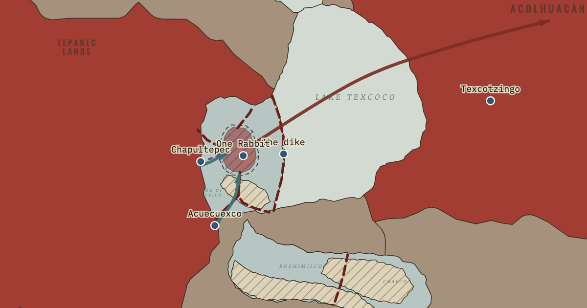
- After the flood usually dated to 1449, Nezahualcoyotl designed a dike of stone, clay and stakes some 12–16 kilometres long from Atzacoalco to Iztapalapa, built by workers drawn from Tlacopan, Culhuacan, Iztapalapa, Tenayuca and Xochimilco.
Practice question: Evaluate the effectiveness of Mexica hydraulic engineering in protecting Tenochtitlan from environmental hazards between 1428 and 1500.
5 more points of evidence, 4 primary sources and the model plan for this question are in the IB notes of chapter 8 in the atlas.
9. Chinampas: Feeding a City
CHAPTER 9 · c. 1430–1519 · CONCEPTS: CHANGE, SIGNIFICANCE, CONSEQUENCE
EVIDENCE TO USE · 1 OF 6
- Chinampas were built by piling lake mud and vegetation inside plots staked out in shallow fresh water and anchoring their edges with ahuejote willows, which gave moist, fertile beds that could carry several crops a year.
Practice question: Examine the importance of the chinampas and the tribute system in sustaining the population of Tenochtitlan.
5 more points of evidence, 4 primary sources and the model plan for this question are in the IB notes of chapter 9 in the atlas.
10. The Planned City
CHAPTER 10 · c. 1430–1519 · CONCEPTS: SIGNIFICANCE, PERSPECTIVES, CHANGE
EVIDENCE TO USE · 1 OF 6
- The sacred precinct at the heart of Tenochtitlan measured roughly 430–460 metres across, and Sahagún’s informants listed 78 structures within it, dominated by the twin shrines of the Templo Mayor to Huitzilopochtli and Tlaloc.
Practice question: To what extent was Tenochtitlan’s plan a solution to environmental problems?
5 more points of evidence, 4 primary sources and the model plan for this question are in the IB notes of chapter 10 in the atlas.
11. The Flower Wars and the End of the System
CHAPTER 11 · 1450s–1521 · CONCEPTS: CAUSATION, CONSEQUENCE, PERSPECTIVES
EVIDENCE TO USE · 1 OF 6
- According to Alva Ixtlilxochitl, the Triple Alliance agreed in 1454 to fight Tlaxcala, Huexotzinco and Cholula in ritual flower wars for captives, while Ross Hassig reads these wars as attrition and Barry Isaac as cover for a failure to conquer.
Practice question: To what extent was Indigenous opposition to the Mexica the main reason for the fall of Tenochtitlan in 1521?
5 more points of evidence, 4 primary sources and the model plan for this question are in the IB notes of chapter 11 in the atlas.
12. Two Answers to the Environment
EPILOGUE · c. 1450–1521 AND AFTER · CONCEPTS: CONTINUITY, CONSEQUENCE, SIGNIFICANCE
EVIDENCE TO USE · 1 OF 6
- Norse Greenland held perhaps 2,000–2,500 people at its height and the Basin of Mexico perhaps 1–1.5 million in 1519, a difference of several hundred times that shaped how each society absorbed climate shocks.
Practice question: Compare and contrast the ways in which the Norse in Greenland and the Mexica in the Basin of Mexico responded to the challenges of their environments.
5 more points of evidence, 4 primary sources and the model plan for this question are in the IB notes of chapter 12 in the atlas.
Practice questions and essay plans
Every chapter ends with a practice question and a model plan: a thesis, three points with evidence and a link back to the question, a counter-argument and a judgement. The plan for chapter 1 is shown in full; for the others, here is the outline, and the rest is in the atlas.
PAPER 2 · CLIMATE AND INNOVATION · CHAPTER 1
To what extent was climate the main reason for the success and failure of medieval societies in demanding environments?
Climate was a decisive condition but rarely the main reason on its own. The warm centuries opened the North Atlantic to Norse farming and the cold narrowed it again, while frost and drought struck the Mexica, yet in both cases social structure, trade and technology decided whether a climatic shock became a lasting catastrophe or a crisis survived.
Climate widened and narrowed the margin for farming at the edge of the habitable world.
EVIDENCEMidges in Scoop Lake show summers about 1.5 °C warmer in 900–1400, when Greenland was settled in 985 or 986, and Gifford Miller dates the onset of the Little Ice Age to 1275–1300, the decades before the Western Settlement emptied.
LINKThe timing of expansion and retreat fits the climate record too closely to be coincidence.
The same climate produced different outcomes for different societies.
EVIDENCEThe Thule Inuit expanded down Greenland’s west coast after 1300 while the Norse withdrew, and Iceland, with perhaps 40,000–60,000 people, survived the cold that ended Norse Greenland.
LINKTechnology and scale separated the survivors from those who left, which shows that climate worked through the societies it struck.
Societies built buffers that changed the effect of climate shocks.
EVIDENCEDuring the frost and drought of 1450–54, which tree rings confirm, Moctezuma I opened the royal granaries and the rulers lifted tribute for six years, while Greenland had no reserves and depended on one export, walrus ivory.
LINKA buffer turned famine into a crisis survived, which shows the weight of institutions.
Climate determinists can point to Dansgaard’s argument of 1975 that cooling had a strong impact on Norse Greenland, and to Zhao’s 2022 record of drying at Lake 578, which suggests that hay failure alone could have made the colony unviable. On this view human choices only changed the timing of an outcome that climate had already decided.
Climate set the margin within which both societies operated, and in Greenland it narrowed that margin decisively. Yet because the Inuit and the Icelanders survived the same cold and the Mexica survived drought, the main explanation lies in how climate interacted with scale, trade and technology, which decided who could absorb a bad decade.
Read the chapter behind this plan: Climate as a Force in History.
PAPER 2 · CLIMATE AND INNOVATION · CHAPTER 3
Examine the impact of Norse settlement on the environment and society of Iceland between 870 and 1100.
Norse settlement transformed Iceland in two opposite ways. It created a durable society governed without a king through the Althing, yet the imported farming system stripped the island’s woodland and exposed its soils, so within two or three generations the settlers had built lasting institutions on an increasingly fragile environment.
Settlement rapidly created a mixed farming society.
The farming system damaged the environment.
The Althing gave Iceland a stable political order.
The evidence for each point, the counter-argument and the judgement are in the IB notes of chapter 3 in the atlas. Read the chapter first: Iceland: A Society on a Volcanic Island.
PAPER 2 · CLIMATE AND INNOVATION · CHAPTER 10
To what extent was Tenochtitlan’s plan a solution to environmental problems?
Tenochtitlan’s plan was to a large extent an environmental solution, since its canals, causeway bridges, aqueduct and waste system made a dense city on water workable. Yet the sacred precinct, the alignment of the quarters and the rebuilding of the Templo Mayor show that religious and political purposes shaped the plan as strongly.
The street and canal grid answered the problem of living on water.
Water supply and sanitation made density possible.
Religion and power organised the centre.
The evidence for each point, the counter-argument and the judgement are in the IB notes of chapter 10 in the atlas. Read the chapter first: The Planned City.
PAPER 2 · CLIMATE AND INNOVATION · CHAPTER 4
Compare and contrast the reasons for the Norse settlement of Greenland and the abandonment of Vinland.
Greenland and Vinland were products of the same expansion, driven by land hunger and made possible by the warm centuries. They ended differently because Greenland offered grassland and a valuable export within reach of Iceland, while Vinland lay too far away, among numerous inhabitants, for a colony of a few thousand people to hold.
Both ventures were driven by the search for new land in a warm period.
Greenland had an export that paid for its imports.
Distance and Indigenous resistance ended Vinland.
The evidence for each point, the counter-argument and the judgement are in the IB notes of chapter 4 in the atlas. Read the chapter first: Greenland and Vinland.
Primary sources
Each chapter’s IB notes carry primary sources with their origin and the context you need before reading them. The sources of chapter 1 are shown in full here.
PICTURE · CHAPTER 1
Central Greenland temperature, AD 700–1700, from the GISP2 ice core
- CREATOR
- Maps of History, from data published by R.B. Alley
- DATE
- 2000 (data); 2026 (chart)
- ORIGIN
- Line chart drawn from the GISP2 temperature reconstruction (NOAA/NCEI paleoclimate study 2475), with dates of Norse settlement and abandonment added
Context. The temperature comes from the share of heavy oxygen in each year’s snow at the summit of the ice sheet, about 3,200 metres high. The series is smoothed and ends in 1855.
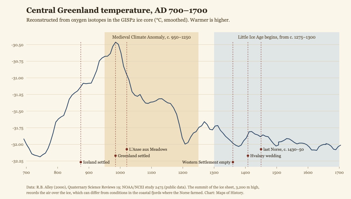
Chart: Maps of History. Data: Alley, R.B. 2000, Quaternary Science Reviews 19: 213–226; NOAA/NCEI study 2475. · original ↗
PICTURE · CHAPTER 1
Drought and wet years in central Mexico, 1300–1600, from tree rings
- CREATOR
- Maps of History, from data published by D.W. Stahle and colleagues
- DATE
- 2011 (data); 2026 (chart)
- ORIGIN
- Bar chart drawn from the Mesoamerican June soil-moisture reconstruction (NOAA/NCEI study 11175), based on Montezuma baldcypress trees at Barranca de Amealco, Querétaro
Context. The record comes from one group of trees about 130 km northwest of the Basin of Mexico; the regional Mexican Drought Atlas (2016) shows the 1452–54 drought more strongly than this single site.
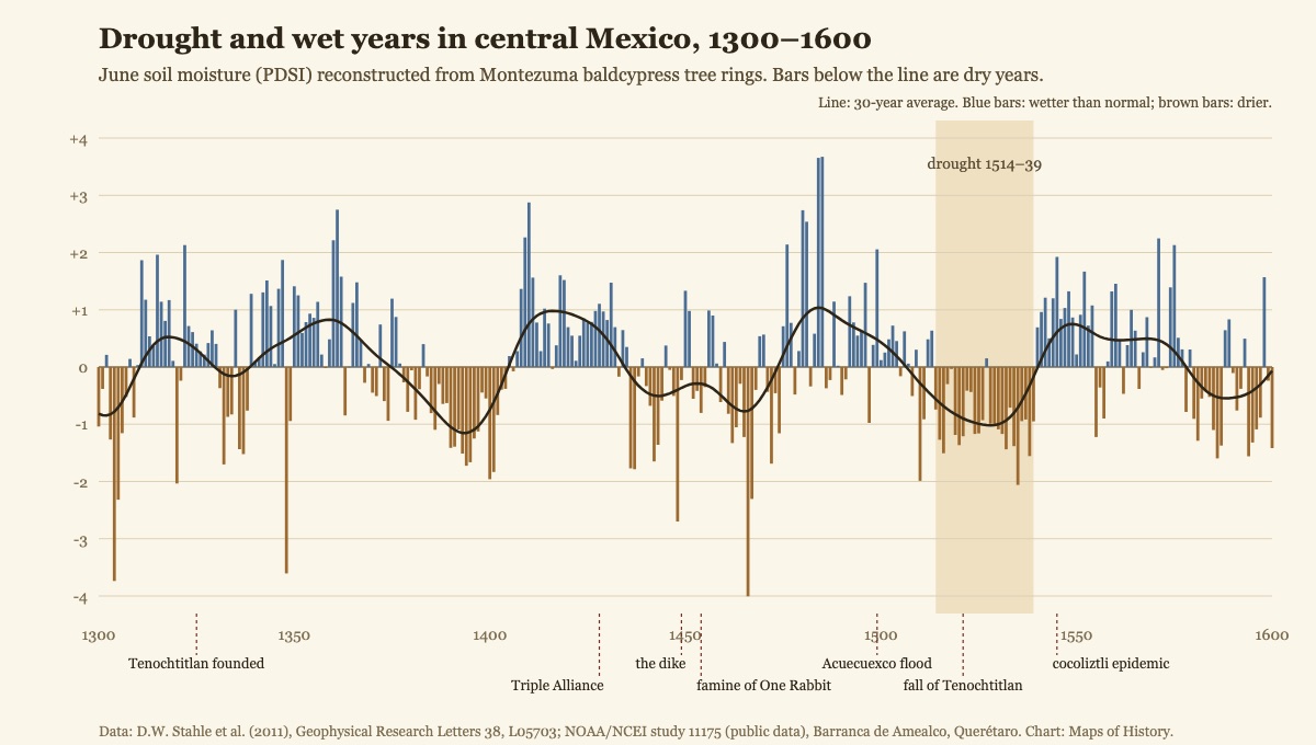
Chart: Maps of History. Data: Stahle, D.W. et al. 2011, Geophysical Research Letters 38: L05703; NOAA/NCEI study 11175. · original ↗
PICTURE · CHAPTER 1
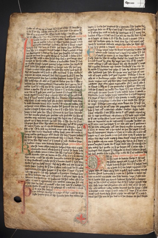
The opening of the Saga of the Greenlanders in Flateyjarbók
- CREATOR
- Scribes Jón Þórðarson and Magnús Þórhallsson
- DATE
- 1387–1394
- ORIGIN
- Manuscript page, GKS 1005 fol., Árni Magnússon Institute for Icelandic Studies, Reykjavík
Context. Flateyjarbók was written in Iceland almost four centuries after the voyages to Greenland and Vinland that this saga describes.
Flateyjarbók, GKS 1005 fol., Árni Magnússon Institute; image via Wikimedia Commons (public domain). · original ↗
TEXT · CHAPTER 1
The King’s Mirror on the ice around Greenland
- CREATOR
- Anonymous Norwegian author
- DATE
- c. 1250
- ORIGIN
- Konungs skuggsjá (The King’s Mirror), a book of instruction written as a dialogue between a father and son, ch. XVI
Context. Written in Norway around 1250, at the end of the warm centuries, by an author who drew on the reports of sailors and merchants who had been to Greenland.
Translation: L.M. Larson, The King’s Mirror (New York: American-Scandinavian Foundation, 1917), pp. 138–139. · original ↗
Every other source in the atlas (42)
- Chapter 2: The Ship and the Sea Road
- The Anglo-Saxon Chronicle on the raid on Lindisfarne Anonymous monastic chroniclers · Entry for 793 (compiled from the late ninth century)
- Alcuin to King Æthelred of Northumbria Alcuin of York · 793
- Ohthere’s account of walrus hunting Ohthere of Hålogaland, recorded at the court of King Alfred · c. 890
- The Gokstad ship Norwegian shipbuilders; photograph by Daderot · Ship built c. 890; photograph 2009
- Chapter 3: Iceland: A Society on a Volcanic Island
- Íslendingabók on the first settler and the wooded land Ari Þorgilsson · 1122–1133
- Íslendingabók on the founding of the Althing Ari Þorgilsson · 1122–1133
- The Law Rock at Þingvellir Photograph by Gerd Eichmann · 2018
- Landnámabók’s sailing directions to Greenland Haukr Erlendsson (compiler of the Hauksbók version) · Early fourteenth century, from older material
- Chapter 4: Greenland and Vinland
- Erik the Red’s Saga on naming Greenland Anonymous Icelandic author · Thirteenth century
- The Saga of the Greenlanders on Leif’s winter in Vinland Anonymous Icelandic author · Thirteenth century (copied in Flateyjarbók, 1387–94)
- The Saga of the Greenlanders on trade with the Skrælings Anonymous Icelandic author · Thirteenth century (copied in Flateyjarbók, 1387–94)
- Reconstructed Norse buildings at L’Anse aux Meadows Photograph by Eric Titcombe · 2013 (reconstructions built by Parks Canada)
- Chapter 5: Living with the Cold
- Ivar Bárðarson’s description of the old sailing route to Greenland Attributed to Ivar Bárðarson, steward at Garðar · Mid-fourteenth century (surviving in later Danish copies)
- Ivar Bárðarson on the Western Settlement found empty Attributed to Ivar Bárðarson, steward at Garðar · Mid-fourteenth century (surviving in later Danish copies)
- Icelandic annals on Greenland, 1347 and 1379 Icelandic annalists · Entries for 1347 and 1379 (manuscripts of the fourteenth to sixteenth centuries)
- The ruin of Hvalsey church, Greenland Norse builders; photograph by Number 57 · Church built probably in the fourteenth century; photograph uploaded 2014
- Chapter 6: What the Norse Left
- The King’s Mirror on Greenland’s imports and exports Anonymous Norwegian author · c. 1250
- The Lewis chessmen Unknown carvers, probably in Trondheim; photograph by Naddoddr · Carved c. 1150–1200; photograph 2025
- The Skálholt map of the North Atlantic Sigurður Stefánsson (original, lost); copied for Þórður Þorláksson · Original c. 1570; surviving copy 1669
- Chapter 7: An Empire Built on a Lake
- The founding of Tenochtitlan in the Codex Mendoza Unknown Nahua painter-scribe (tlacuilo) · c. 1541–42
- Cortés on the lakes and the island city Hernán Cortés · 30 October 1520
- A lament attributed to Nezahualcoyotl Attributed to Nezahualcoyotl, ruler of Texcoco (1402–72) · Fifteenth century (written down in Spanish in the early seventeenth century)
- Chapter 8: Water: Dikes, Aqueducts and Floods
- Torquemada on the building of the dike Juan de Torquemada, Franciscan friar · Published 1615 (this edition 1723)
- Nezahualcoyotl’s dike on the 1524 Nuremberg map Unknown draughtsman; woodcut printed by Friedrich Peypus · 1524
- Alva Ixtlilxochitl on the snow of 1450 and the famine that followed Fernando de Alva Ixtlilxochitl, historian descended from the rulers of Texcoco · c. 1610–40
- Durán on the Acuecuexco flood of 1499 Diego Durán, Dominican friar · c. 1581
- Chapter 9: Chinampas: Feeding a City
- The tribute of Tochtepec in the Codex Mendoza Unknown Nahua painter-scribe (tlacuilo) · c. 1541–42
- Grain bins in the Codex Mendoza Unknown Nahua painter-scribe (tlacuilo) · c. 1541–42
- Cortés on the great market Hernán Cortés · 30 October 1520
- Bernal Díaz on the market of Tlatelolco Bernal Díaz del Castillo, soldier with Cortés · Written c. 1550s–1570s (published 1632)
- Chapter 10: The Planned City
- Bernal Díaz on the first sight of the lake cities Bernal Díaz del Castillo, soldier with Cortés · Written c. 1550s–1570s (published 1632)
- Bernal Díaz on the view from the great temple Bernal Díaz del Castillo, soldier with Cortés · Written c. 1550s–1570s (published 1632)
- Cortés on the aqueduct and the water supply Hernán Cortés · 30 October 1520
- The 1524 Nuremberg map of Tenochtitlan Unknown draughtsman; woodcut printed by Friedrich Peypus · 1524
- Chapter 11: The Flower Wars and the End of the System
- Sahagún on the smallpox epidemic of 1520 Bernardino de Sahagún, Franciscan friar, with Nahua informants · Compiled c. 1555–1577
- Smallpox in the Florentine Codex Nahua artists working with Bernardino de Sahagún · c. 1575–77
- Cortés on cutting the aqueduct and the hunger in the city Hernán Cortés · 15 May 1522
- Tlaxcalan warriors and their Spanish allies in the Lienzo de Tlaxcala Tlaxcalan painters; later copy of the lost original · Original c. 1550s
- Chapter 12: Two Answers to the Environment
- An Inuit tradition of the first meeting with the Norse Greenlandic storytellers, recorded and translated by Hinrich Rink · Recorded in the nineteenth century; published 1875
- Thule-culture snow goggles Thule-culture maker, Alaska · c. 800–1200
- Model of chinampas in the Templo Mayor Museum Museum model; photograph by Thelmadatter · Photograph 2008
- The Templo Mayor ruins and the cathedral of Mexico City Photograph by Thelmadatter · 2008
Internal Assessment starting points
Each starting point is an idea for an investigation: a question, the concept it tests, the kinds of sources you could use and where they are held, and one caution. The investigation must be your own work, and your teacher approves the question.
How far do ice-core and lake-sediment records support the Icelandic annals’ evidence of a cooling climate in Norse Greenland between 1250 and 1450?
CONCEPTCausation
SOURCESPublished proxy data (GISP2 temperature series, lake-sediment studies), translated Icelandic annals and the description attributed to Ivar Bárðarson.
CAUTIONProxy records measure different things in different places, so explain what each record shows before comparing it with written sources.
To what extent do the two Vinland sagas give a reliable account of Norse contact with Indigenous peoples in North America?
CONCEPTPerspectives
SOURCESThe Saga of the Greenlanders and Erik the Red’s Saga in translation, excavation reports from L’Anse aux Meadows and the 2021 tree-ring dating.
CAUTIONThe sagas give only the Norse view, written two centuries later, and Indigenous perspectives survive only indirectly through archaeology.
How useful is the Codex Mendoza for measuring the scale of Mexica tribute?
CONCEPTSignificance
SOURCESThe tribute pages of the Codex Mendoza, their Spanish annotations and modern commentaries.
CAUTIONThe codex was made for Spanish officials about twenty years after the conquest, and scholars disagree about whether its quantities were paid each year.
Why did the Mexica build the dike of Nezahualcoyotl, and how effective was it?
CONCEPTConsequence
SOURCESChronicles by Torquemada, Durán and Alvarado Tezozómoc, the 1524 Nuremberg map and modern archaeological surveys of the lake bed.
CAUTIONThe surviving accounts were written decades later by friars and mestizo historians who often drew on each other, so their agreement is weaker evidence than it looks.
To what extent was the smallpox epidemic of 1520 decisive in the fall of Tenochtitlan?
CONCEPTCausation
SOURCESBook XII of the Florentine Codex, Cortés’s letters, Indigenous annals and modern demographic studies.
CAUTIONPopulation figures before and after the epidemic are uncertain, so name the source and range of any mortality figure you use.
How far did changing trade, more than climate, cause the abandonment of Norse Greenland?
CONCEPTCausation
SOURCESAncient-DNA studies of walrus ivory, the King’s Mirror, Icelandic annals and archaeological reports on Greenland farms.
CAUTIONMuch of the evidence is scientific and statistical, so read the papers carefully and avoid treating a match in timing as proof of cause.
How far have the chinampas of Xochimilco survived as a continuous farming tradition since 1521?
CONCEPTContinuity
SOURCESColonial land records, travellers’ accounts, the UNESCO nomination file and modern agricultural studies.
CAUTIONModern chinampas differ from those of 1519 in crops, water supply and use, so continuity has to be tested with evidence at each stage.
Revision tools
The atlas ends with a map quiz that asks you to find places and moments on the map itself (part of membership and of the Exam Sprint). The quick quiz and the discussion questions with our answers are free pages on this site, and the printable study guide gathers every chapter’s notes into one document for revision.
Maps of History is independent and is not affiliated with or endorsed by the International Baccalaureate Organization. IB course names describe alignment only; paper, theme and section names follow the new course outline and may change when the final guide is published.
THE DISPATCH
A short welcome series, then a letter when a new atlas opens — and the printable study guide for Climate and Innovation is yours now, free.
NO TRACKING · YOUR ADDRESS IS USED FOR THE DISPATCH AND NOTHING ELSE · UNSUBSCRIBE ANYTIME