Norse and Aztecs · CHAPTER 8 ·
Aztec dikes, aqueducts and floods
Chapter 8 of Climate and Innovation: The Norse and the Aztecs, c. 790–1521: “Water: Dikes, Aqueducts and Floods”
Around 1449, after floods drowned parts of Tenochtitlan, Moctezuma I turned to Nezahualcoyotl of Texcoco, who directed a dike about 16 km long across Lake Texcoco against floods and salt water. An aqueduct from Chapultepec, begun around 1454 and working by 1466, brought drinking water, but each solution created new risks.
Chapter 8 is part of membership. WW2 is free — every chapter. Try chapters 1–2 of any 2 other atlases (3 with a free account). Opening a new atlas uses one of them. Membership opens all 21 — Join.
Free printable Norse and Aztecs study guide, sent by email ↓
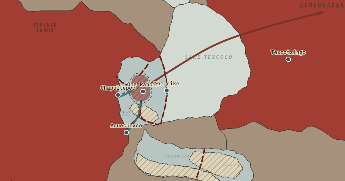
The map above is the world of The Basin of Mexico, 1499 — Ahuitzotl’s conquests — and the flood.
Part of IB History: The Norse and the Aztecs →
BRIEF EXPLANATION — THE ESSENTIAL ARGUMENT
Once the Triple Alliance, the partnership of Tenochtitlan, Texcoco and Tlacopan, controlled the lake, its rulers set out to engineer it, and each solution they built solved one danger while creating another. Around 1449, after floods drowned parts of Tenochtitlan, the ruler Moctezuma I turned to Nezahualcoyotl of Texcoco, who directed the building of a dike about 16 kilometres long across Lake Texcoco, from Atzacoalco in the north to Iztapalapa in the south. The dike, a wall of stone and clay held between rows of stakes, worked like a modern flood barrier and also kept the salty eastern water away from the city. On the map, it is the dark line east of the island, and the western lagoon turns from salt to fresh water behind it. A single structure had turned part of a salt lake into farmland and safe water.
Drinking water followed the same pattern of solutions that created new risks. An aqueduct, a channel carrying water over long distances like a modern water main, was rebuilt from the springs of Chapultepec, begun around 1454 and working by 1466, with two channels so that one could be cleaned while the other flowed; it is drawn as a dashed blue line. Yet engineering could not control the sky: between 1450 and 1454 frosts, floods and drought ruined harvests, and in the worst year, named One Rabbit in the Mexica calendar, families sold themselves into slavery on the Gulf coast for maize. In 1499 the ruler Ahuitzotl brought in a second aqueduct from the springs of Acuecuexco, and its water flooded the city it was meant to serve. The century’s lesson was that every gain in control raised the stakes of failure, because more people now depended on the system working.
The full story
The dike, a flood barrier across the lake, was the alliance’s answer to the basin’s two great hazards, flood and salt, and it shows how political power became engineering power. The chroniclers say that Moctezuma I asked Nezahualcoyotl to design it after several wet years, usually dated to 1449, raised the lake over the city. Workers from Tlacopan, Culhuacan, Iztapalapa, Tenayuca and Xochimilco built a wall of stone and clay, faced on both sides with densely driven stakes, from Atzacoalco to Iztapalapa. Later writers assumed it had gates to let water through, though Josefina García Quintana and José Rubén Romero Galván found no evidence for them. By blocking the salty water of eastern Lake Texcoco, the dike turned the western part into a fresher lagoon, the Lake of Mexico, where new chinampas, raised fields built up from the lake bed like garden beds in water, could be built.
Drinking water was a separate problem, because the island had no springs of its own, so it depended on an aqueduct, a channel carrying spring water from the shore like a modern water main. A first channel of clay and reeds from Chapultepec, built in the 1420s, kept failing, so Moctezuma I ordered a better one, again with Nezahualcoyotl’s advice, begun around 1454 and working by 1466. Its channels of tightly packed earth and mortar ran beside the causeway from Tlacopan, and Spanish observers later noted that the water ran in one channel while the other was cleaned. From the city’s edge, the water was carried by canoe and sold. The aqueduct and the dike were political monuments as much as utilities, since only a ruler who could summon thousands of workers from many towns could build them.
The years after 1450 showed both what engineering could not prevent and what it could cause. The chronicles describe years of rain, hail and early frosts followed by drought, and the Mexican Drought Atlas, built from tree rings, confirms a great drought in 1452–54. In 1454, the year named One Rabbit in the Mexica calendar, people sold themselves or their children to the Totonacs of the Gulf coast in exchange for maize, and Moctezuma I opened the royal granaries. The disaster pushed the alliance to conquer the warm, wet Gulf lowlands for a reliable food supply. In 1499 Ahuitzotl ignored the warnings of Tzotzomatzin, ruler of Coyoacán, who was killed for them, and brought the powerful spring of Acuecuexco into the city. The water broke out and flooded Tenochtitlan until divers sealed the spring, which shows how a system grown more ambitious had also grown more dangerous.
DEEP EXPLANATION — EVIDENCE & INTERPRETATION
Nezahualcoyotl the engineer: evidence and legend
Nezahualcoyotl, ruler of Texcoco from 1431 to 1472, appears in the sources as poet, lawgiver and engineer, and historians have to separate his achievements from the reputation his descendants built. The most detailed praise comes from Fernando de Alva Ixtlilxochitl, a seventeenth-century writer descended from him, whose histories magnify Texcoco’s role. Yet Mexica sources, which had little reason to flatter a rival city, also credit him with the dike and the Chapultepec aqueduct, and the Codex Mexicanus shows him directing the aqueduct work in the year Thirteen Rabbit, 1466. His hill garden at Texcotzingo, with channels, pools and baths carved into the rock and fed by water brought from the eastern mountains, survives as physical evidence of his interest in hydraulics. The fairest conclusion is that he was a real organiser of great works, while the image of a lone genius owes much to later writers. The great works themselves were the achievement of thousands of labourers from many towns, whose names no source records.
The famine of One Rabbit: documents, trees and responses
The famine of the 1450s can be reconstructed from several kinds of evidence, which together show how the Mexica state responded to climate stress. Nahua annals give its years differently, from Ten Rabbit, 1450, to One Rabbit, 1454, and Agustín García Márquez argues that some made 1454 the first year of hunger and others the worst. The Mexican Drought Atlas published by David Stahle’s team in 2016 confirms a severe drought across central Mexico in 1452–54. Responses ranged across society, from the poorest to the ruler. Families sold children or themselves to the Totonacs and to the Cohuixcas of Guerrero in exchange for food, the ruler distributed grain from the royal storehouses, and many people migrated to the Gulf coast. Leonardo López Luján has linked an offering at the Templo Mayor containing the remains of at least 42 children, given to the rain god Tlaloc, to the same drought. The empire’s later push toward the Gulf coast was, in part, a search for food security.
Acuecuexco, 1499: hubris or accident?
The flood caused by the Acuecuexco aqueduct is often told as a morality tale of a proud ruler punished, and the sources invite that reading. Durán and Alvarado Tezozómoc describe Ahuitzotl seizing the powerful springs on the border of Coyoacán, ignoring the advice of Tzotzomatzin, who warned that the water could not be controlled, and having him killed. The new stone-and-mortar channel delivered so much water that houses collapsed and people fled, until, on the advice of Nezahualpilli of Texcoco, divers blocked the springs with offerings. The Annals of Tlatelolco date the rising water to Seven Reed, 1499, and a protective wall to the next year. Historians read the episode as evidence of real engineering limits, since a closed basin with a growing city had little room for extra water. The story also shows that even within the alliance, Texcoco claimed the role of wise adviser to Tenochtitlan, and that the chroniclers used water to talk about the limits of royal power.
Key places on the map
Why it happened
Floods drowned the growing city. Because the Basin of Mexico had no outlet, a run of wet years raised the lake across the islands, and the chronicles report such a flood around 1449. A small village could move, but a city of tens of thousands with temples and palaces could not. The scale of the investment in the island forced its rulers to protect it, which is why the dike was built after, and because of, the city’s growth.
Salt water limited the farms around the city. The lagoon around Tenochtitlan was part of salty Lake Texcoco, which made it poor for chinampas, since crops cannot grow in brackish water. Separating the western lagoon from the salty east promised fresher water that could be farmed, so the dike was an agricultural project as well as a flood defence. Its success opened the way for chinampa expansion in the decades after 1449, close enough to the city for produce to arrive fresh by canoe.
An island without springs needed piped water. Tenochtitlan’s people drank water carried from the springs of Chapultepec on the western shore, which became impossible to supply by canoe alone as the population grew. The first aqueduct of clay and reeds failed repeatedly. A reliable channel was therefore essential to any further growth, and the second aqueduct, working by 1466, made a much larger city possible, with fountains in the palaces and water sold from canoes in every district.
Power over many towns supplied the labour. Great waterworks needed thousands of workers, stone quarried leagues away and timber for stakes, which no single town could provide. The victory of 1428 gave the Triple Alliance the authority to call on labour from towns around the lake, from Tlacopan to Xochimilco. Hydraulic engineering in the basin was therefore a product of empire, much as modern dams depend on states able to raise large sums and workforces, and the works in turn advertised the alliance’s power.
THE TURNING POINT
Nezahualcoyotl’s dike, c. 1449. The building of the dike is the hinge of this chapter because it changed the lake itself. Before it, the people of the basin adapted to the lake as nature made it; after it, the western lagoon was a managed body of water, fresher and protected, that could be farmed and built upon. On the map, the lagoon turns from pale salt to blue-grey fresh water in the snapshot of 1449. That transformation enabled the expansion of chinampas and the growth of the city in the next seventy years, and it committed the Mexica to maintaining an artificial environment.
What it changed
Fresher water allows new chinampas. With the western lagoon freshened, new chinampas spread around the island and south toward Iztacalco and Mexicaltzingo, where the map shows fields in the lagoon after 1469. More land under cultivation close to the city supported more people, and Chapter 9 follows how chinampas, tribute and markets together fed a city of perhaps 200,000 people. Engineering and farming had become a single system.
Food security drives conquest. The famine of 1450–54 taught the Mexica that the basin alone could fail them, and the following years brought campaigns toward the warm, rain-fed Gulf coast, including Cuetlaxtlan, from which tribute in food and cotton flowed. Imperial expansion became, in part, an insurance policy against the climate of the high basin, as the tribute provinces painted tan on the empire map show, stretching to both coasts by 1500.
An engineered lake becomes a trap. The dike, causeways and aqueducts made Tenochtitlan dependent on structures that an enemy could seize or cut. In 1521 Spanish brigantines broke through the dike and Cortés’s allies cut the Chapultepec aqueduct, turning the engineered lake against its builders, as Chapter 11 explains. The more completely the city relied on built structures, the more an enemy could do by seizing a few of them.
DISCUSSION QUESTION — Did the Mexica control their environment, or did their engineering simply increase the risks they faced?
The evidence supports both claims, and the tension between them is the point. The dike reduced flooding and freshened the lagoon, the double-channel aqueduct supplied reliable drinking water, and royal granaries cushioned the famine, so in ordinary years the Mexica controlled the lake far better than their predecessors. Yet the famine of 1450–54 showed that frost and drought could not be engineered away, and the Acuecuexco flood of 1499 showed that ambition could overreach the limits of a closed basin. Engineering also allowed the city to grow, which meant that any failure would harm more people. Historians of risk call this the safe-development paradox, in which protection encourages concentration that raises the cost of a disaster. A balanced judgement is that the Mexica achieved real control within limits they did not fully understand. The transferable insight is that successful adaptation often raises a society’s exposure to the shocks it has not planned for.
An interesting fact
The famine of 1454 left two phrases in the Nahuatl language. The year’s name in the Mexica calendar was Ce Tochtli, One Rabbit, and the sources describe the people of that year as having been “rabbited”, necetochuiloc, an expression for suffering famine. They also say that the people “became Totonacs”, because so many fled to the Totonac lands of the Gulf coast, or were sold there, in search of maize. A calendar date and the name of a neighbouring people had become words for hunger and flight, so that the language itself carried the memory of a climate disaster.
Related
THE FREE PRINTABLE STUDY GUIDE
Join the Dispatch — a short welcome series, then a letter when a new atlas opens — and the printable study guide for Climate and Innovation is yours now, free.
NO TRACKING · YOUR ADDRESS IS USED FOR THE DISPATCH AND NOTHING ELSE · UNSUBSCRIBE ANYTIME