Norse and Aztecs · 1519
Was Tenochtitlan’s plan about environment or power?
The seminar question: “Was Tenochtitlan’s plan primarily a solution to environmental problems or an expression of political and religious power?”
Tenochtitlan was a planned city on water: four quarters around a walled sacred precinct dominated by the Templo Mayor, a rough grid of streets and canals, and three causeways with removable bridges linking it to the shore. Drinking water came by aqueduct from Chapultepec, and human waste was collected by canoe for fertiliser.
Chapter 10 is part of membership. WW2 is free — every chapter. Try chapters 1–2 of any 2 other atlases (3 with a free account). Opening a new atlas uses one of them. Membership opens all 21 — Join.
Free printable Norse and Aztecs study guide, sent by email ↓
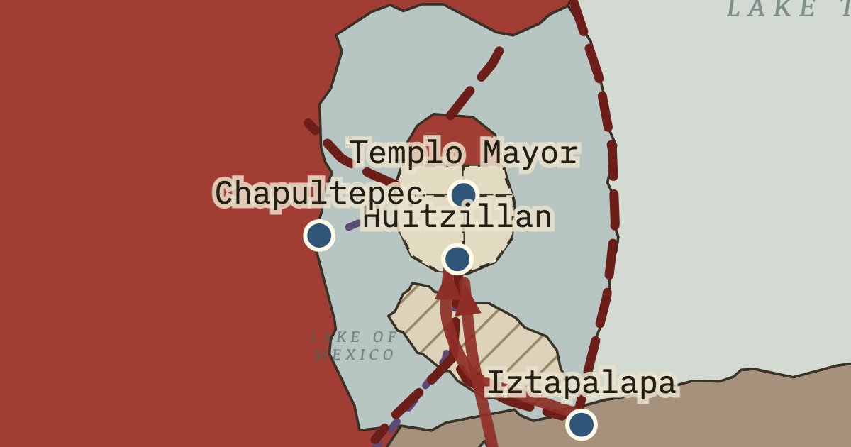
The city’s layout expressed a religious idea and solved practical problems at the same time. At its centre stood the sacred precinct, roughly 430–460 metres across, where the friar Bernardino de Sahagún’s informants listed 78 structures, dominated by the Templo Mayor, a pyramid with twin shrines to Huitzilopochtli, god of war and the sun, and Tlaloc, god of rain. Excavations led by Eduardo Matos Moctezuma since 1978 show that the temple was enlarged in seven major building stages. The causeways leading north, west and south divided the island into four quarters, Moyotlan, Teopan, Atzacoalco and Cuepopan, and each was split into neighbourhoods called calpolli, about seventy in all. A calpolli worked much like a modern borough, with its own temple, school and local officials, so the city could be governed in manageable units.
The short answer
- Life on water demanded planning. A city on islands in a shallow lake could not grow haphazardly, because every new house lot had to be built up from the lake bed and connected to canals for transport and drainage. Expansion meant building chinampas outward from the island’s edge in regular rows. The environment itself pushed the Mexica toward an orderly grid of streets and canals, so planning followed from the decision to build on water.
- Hydraulic works made a large city possible. The dike of about 1449 protected the island from floods and freshened the lagoon, and the aqueduct working by 1466 delivered reliable drinking water. Without these works the city could not have grown much beyond the size of its early decades. The planned city of 1519 was therefore built on the engineering of the mid-fifteenth century, which turned a hazardous lake into habitable space for perhaps 200,000 people. Engineering came first, and the planned city followed it.
- Tribute paid for monumental building. The temples, palaces and causeways of Tenochtitlan required stone, timber, lime and labour drawn from across the basin and beyond. Tribute from subject provinces supplied many of these materials and fed the workers, and rulers competed to enlarge the Templo Mayor as a display of imperial power. The city’s grandeur was the capital’s share of an empire’s wealth, made visible in stone at the very centre of the lake. Imperial tribute and urban grandeur therefore rose and fell together.
- Religion organised space. Mexica religion placed the Templo Mayor at the centre of the cosmos, the point where the earthly world met the heavens and the underworld, and the four quarters reflected the four directions of the universe. Building the city as a cosmic diagram gave rulers legitimacy and gave every resident a place within a sacred order. Religious ideas and practical planning therefore pointed in the same direction, which helps explain why residents maintained the system so carefully.
THE TURNING POINT
Huitzillan, 8 November 1519. The meeting of Moctezuma II and Hernán Cortés at the edge of the city on 8 November 1519 is the hinge of this chapter because it is the moment the planned city entered the written record of outsiders, and the moment its future turned. The Spaniards’ astonished descriptions are the main written evidence of what ninety years of Mexica engineering had produced. Within twenty months the same causeways, canals and aqueduct would become the battlefield of a siege. The hinge is therefore double, marking both the high point of the lake city and the arrival of the force that would destroy it.
What it changed
A city the Spaniards would rebuild on. After the conquest the Spaniards built Mexico City on the ruins of Tenochtitlan, keeping the main causeways as streets and placing the cathedral and viceregal palace on the sacred precinct and Moctezuma’s palace. The old grid survives in the street plan of the modern historic centre, which shows how lasting the Mexica plan has been even after the lake beneath it was drained.
The causeways become battle lines. The causeways that linked the city to the shore and made it accessible also made it vulnerable. During the Spanish retreat of June 1520 and the siege of 1521, the fighting concentrated on the causeways and their bridges, where the gaps that once let water flow became deadly obstacles. Chapter 11 follows how the city’s plan, built for peace, shaped its fall in war.
A model for later comparison. Tenochtitlan’s combination of canals, aqueducts and waste recycling has made it a favourite comparison for modern debates about sustainable cities. Historians caution against romanticising it, since its order rested on tribute and forced labour, but its management of water and waste remains a striking example of an engineered urban environment, and one that was already more than a century old when Europeans first saw it.
The full answer, argued
The plan was both, and the strongest answers show how the two reinforced each other. Environmental needs shaped the grid of streets and canals, the removable bridges on the causeways, the aqueduct and the recycling of waste, all of which made a dense city on water workable. Political and religious power shaped the sacred precinct at the centre, the alignment of the causeways and quarters with the four directions, and the repeated enlargement of the Templo Mayor, which advertised each ruler’s strength. Even the hydraulic works were political, since only a powerful state could command the labour they required, and the shrine to the rain god Tlaloc on the Templo Mayor placed water at the heart of religion. Historians still debate how far the residential districts were planned from above. The transferable insight is that the most effective environmental technologies are often embedded in political and religious systems that give people reasons to build and maintain them.
An interesting fact
The rediscovery of the Templo Mayor began by accident in the early hours of 21 February 1978, when workers from the city’s electricity company, digging a trench at the corner of two streets behind the cathedral of Mexico City, struck a carved stone. It was a great disc of pink andesite, about 3 metres across and weighing roughly 8 tonnes, showing the dismembered moon goddess Coyolxauhqui. Its discovery led the government to demolish a block of colonial-era buildings so that archaeologists led by Eduardo Matos Moctezuma could excavate the temple beneath, which now lies open beside the cathedral.
This is the study layer of Layout of Tenochtitlan, chapter 10 of Climate and Innovation: The Norse and the Aztecs, c. 790–1521; the full index of the atlas is here.
Related questions
THE FREE PRINTABLE STUDY GUIDE
Join the Dispatch — a short welcome series, then a letter when a new atlas opens — and the printable study guide for Climate and Innovation is yours now, free.
NO TRACKING · YOUR ADDRESS IS USED FOR THE DISPATCH AND NOTHING ELSE · UNSUBSCRIBE ANYTIME