Norse and Aztecs · CHAPTER 9 ·
Aztec chinampas
Chapter 9 of Climate and Innovation: The Norse and the Aztecs, c. 790–1521: “Chinampas: Feeding a City”
Chinampas were raised fields built in the shallow fresh lakes of Xochimilco and Chalco from mud and plants anchored by willows, where water softened frost. With a market and imperial tribute, they helped feed Tenochtitlan’s perhaps 200,000 people after the Triple Alliance took Xochimilco around 1430 and Chalco by about 1465.
Chapter 9 is part of membership. WW2 is free — every chapter. Try chapters 1–2 of any 2 other atlases (3 with a free account). Opening a new atlas uses one of them. Membership opens all 21 — Join.
Free printable Norse and Aztecs study guide, sent by email ↓
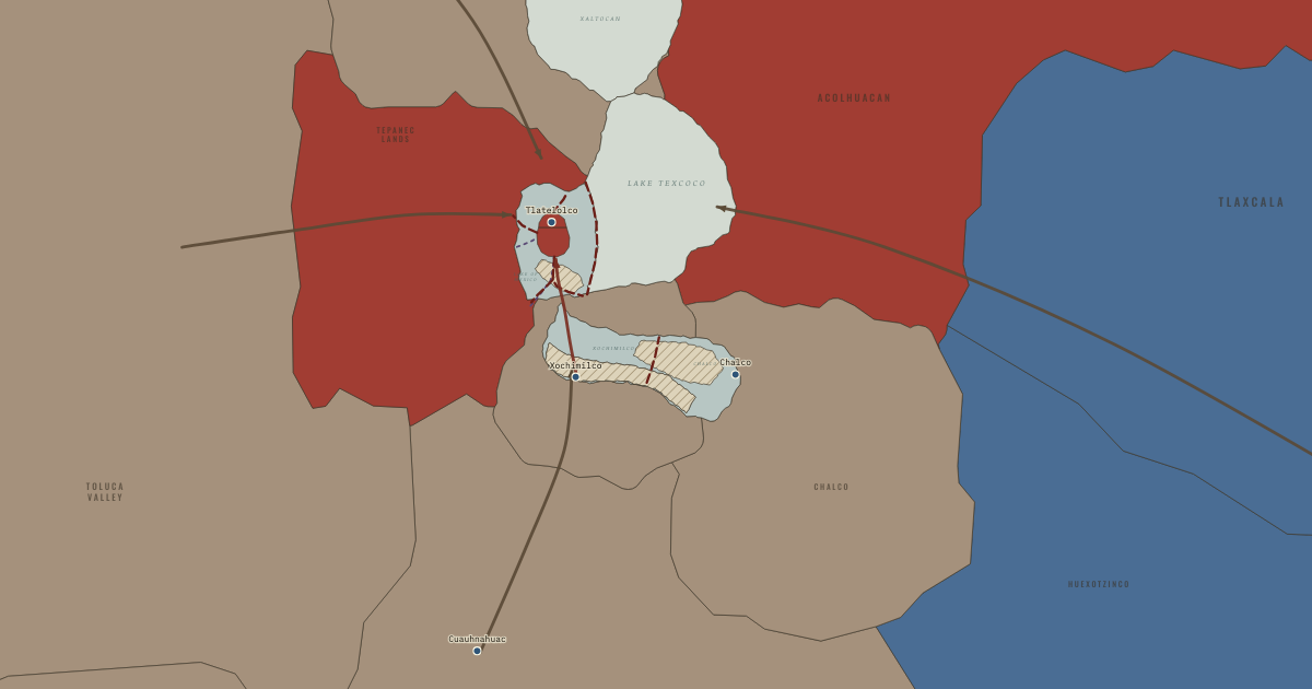
The map above is the world of The Basin of Mexico, 1515 — The empire at its height under Moctezuma II.
Part of IB History: The Norse and the Aztecs →
BRIEF EXPLANATION — THE ESSENTIAL ARGUMENT
Feeding a city of perhaps 200,000 people at 2,240 metres required three systems working together: intensive farming in the lake, a great market, and tribute from a wide empire. The farming system was the chinampa, a raised field built in shallow fresh water by piling mud and plants on a frame of reeds and anchoring the edges with willow trees, so that each field was an island surrounded by canals. Water seeping up from below kept the soil moist, mud dredged from the canals renewed its fertility, and the surrounding water softened frosts, which made chinampas among the most productive farms in the pre-industrial world. On the map, the pale fields along the shores of Xochimilco and Chalco are the chinampa districts. They worked much like a modern hydroponic greenhouse built from the lake itself, turning the basin’s greatest hazard, frost, into a problem that water could solve.
Chinampas alone could not feed Tenochtitlan, so the empire filled the gap. The great market of Tlatelolco drew, by Hernán Cortés’s estimate, more than 60,000 people a day, buying with cacao beans and cotton cloaks as money, and canoes brought produce from around the lake. Tribute, goods owed by conquered provinces much like taxes paid in kind, flowed in from 38 provinces listed in the Codex Mendoza, a painted record made for the Spanish viceroy: maize, beans and amaranth stored in great bins, cotton cloth, cacao and feathers. On the map, the tribute arrows enter the basin from every edge of the frame. The system’s strength was diversity, since food came from the lake, the market and the empire at once, and its weakness was that the city’s size depended on all three continuing to work together.
The full story
The chinampa, a raised field built up from the lake bed like a garden bed standing in water, was an innovation in soil and water management, refined over centuries before the Mexica took control of it. Farmers dug canals by hand in the shallow southern lakes and piled the mud and plant matter into long rectangular beds, held in place by stakes and by willows called ahuejotes whose roots bound the edges. Seedlings were raised in nurseries of mud cut into small blocks and then transplanted, so a field could grow several crops a year. Studies summarised by José Luis de Rojas and Juan José Batalla estimate maize yields of about 3,000 kilograms per hectare on chinampas, against 1,000–1,400 on ordinary fields. The water also moderated temperatures, reducing the risk of frost that threatened rain-fed maize, so the chinampa answered the basin’s chief climatic hazard directly.
The Mexica state turned an older local technique into a regional system. The alliance conquered Xochimilco around 1430 and Chalco by about 1465, gaining the two largest areas of fresh water in the basin, and many historians think the state then organised a large expansion of chinampas. Pedro Armillas mapped the southern chinampa zone from air photographs in 1971 and showed it was far larger than previously thought, and totals of roughly 9,000–12,000 hectares are commonly given. Lee Arco and Elliot Abrams estimate that building the system took about 25 million person-days, each one person’s work for one day, over forty years, a task local communities could manage, though perhaps under state direction. Jeffrey Parsons argued that the chinampas supplied a large share of the city’s food, enough for perhaps 100,000 people or more, though not the whole of it, which is why the city could never stop relying on its empire.
The rest came through exchange and tribute, which tied the city’s diet to its empire. At Tlatelolco, Bernal Díaz recalled, soldiers who had seen Rome and Constantinople said they had never seen a market so large, orderly and crowded. Small purchases were paid in cacao beans and larger ones in cotton cloaks called quachtli, each worth between about 65 and 100 beans. The Codex Mendoza, a painted book recording the tribute owed by each province much like a tax register, shows 42 great bins of grain sent as tribute, but historians debate how large they were and how often they were filled. Population estimates for Tenochtitlan range from under 100,000 to over 300,000, and Michael Smith’s figure of 212,500 on 13.5 square kilometres lies within the common range. A city that size could exist only because lake, market and empire all fed it at once.
DEEP EXPLANATION — EVIDENCE & INTERPRETATION
How productive were the chinampas?
Claims about chinampa productivity range from sober to wildly inflated, and the evidence supports a strong but limited case. Popular accounts speak of seven harvests a year, which specialists reject, since maize gave one or two crops while vegetables and flowers, raised in nurseries and transplanted, gave several. The yield figure of about 3,000 kilograms of maize per hectare comes from Bernard Ortiz de Montellano’s work, cited by Rojas and Batalla, and compares with 1,000–1,400 kilograms on rain-fed land. The area under cultivation is less certain, since Armillas mapped the zone without publishing a single precise total, and estimates of 9,000–12,000 hectares are repeated more often than they are demonstrated. Parsons calculated that the chinampas could have fed perhaps 100,000 people or more, a large fraction of the city but not all of it. The chinampa’s great advantage was reliability, since constant moisture and frost protection made yields steadier than those of fields that depended on the rains, and steadiness mattered more than peak output in a basin of frosts and droughts.
Counting the tribute in the Codex Mendoza
The tribute pages of the Codex Mendoza look precise, and that precision hides a real puzzle about scale. Each of the 38 provinces is shown with its towns and with the goods it owed, painted as symbols with numbers attached, and the Spanish notes explain them. Rojas and Batalla point out that historians disagree about whether a given glyph means one item or a load of twenty, and about whether payments came once, twice or four times a year. On the highest reading, the cloth listed amounts to several million pieces a year, and on the lowest, to about a twentieth of that. The 42 grain bins may each have held hundreds of tonnes, but Pedro Armillas doubted that the grain ever travelled to the capital, suggesting the bins were reserves held in the provinces. Popular figures of thousands of tonnes of maize and millions of cloaks have no traceable scholarly source, so a careful historian presents the tribute as large, organised and of uncertain size.
Why estimates of Tenochtitlan’s population differ
Estimates of Tenochtitlan’s population differ by a factor of three or more because each rests on a different method and set of assumptions. Spanish conquerors gave round figures such as 60,000 houses, which may refer to households, to buildings or to the whole basin. William Sanders, Jeffrey Parsons and Robert Santley estimated 150,000–200,000 people from the city’s area of 12–15 square kilometres and densities known from colonial records. Edward Calnek reconstructed house lots from early colonial documents and reached higher figures, which he called tentative. Michael Smith’s 2005 study, comparing densities across Mesoamerican cities, gave 212,500 on 13.5 square kilometres. Low estimates of 60,000–100,000 assume smaller households or less built-up land. The range matters for this atlas because the number of mouths decides how much the chinampas, the market and the tribute had to provide, and every estimate implies a city far too large to feed itself from its own island. Whatever the true figure, Tenochtitlan was a city whose survival depended on food grown elsewhere.
Key places on the map
Why it happened
Frost and unreliable rain threatened ordinary fields. At over 2,200 metres, rain-fed maize risked early frost in September and depended on summer rains that could fail, as they did in 1452–54. Chinampas avoided both dangers, since water seeped up from below and the lake moderated the night-time cold. The technique was therefore an adaptation to the basin’s particular climate, turning the lake’s shallow margins into the safest farmland available, much as irrigation protects modern farmers against a dry season.
The dike freshened water for new fields. Chinampas need fresh water, because salt kills crops, so they flourished in the spring-fed southern lakes and could spread around Tenochtitlan only after Nezahualcoyotl’s dike separated the western lagoon from salty Lake Texcoco around 1449. On the map, chinampa fields appear in the lagoon south of the city by 1469. Hydraulic engineering and farming innovation reinforced each other, since each made the other more valuable. The chinampa boom of the later fifteenth century was therefore a by-product of flood control.
Conquest gave the state control of the best water. Control of the freshwater lake towns tied farming to conquest. The alliance conquered Xochimilco and the lake towns around 1430 and the Chalco confederation by about 1465, after decades of war. Control of these towns gave the Mexica state access to the largest freshwater farming zones in the basin and the labour of the people who worked them, so that agricultural expansion followed military victory. Imperial power and chinampa farming grew together, each paying for the expansion of the other.
A growing city needed food on a scale no island could supply. Tenochtitlan’s population grew from a few thousand in the 1300s to perhaps 150,000–200,000 or more by 1519, crowded onto about 13.5 square kilometres of island. Even the most intensive farming in the lake could not feed such numbers, so the city drew on markets and tribute from far beyond the basin. Growth itself drove the search for new sources of food, which pulled the empire outward toward the warm, wet lowlands of the Gulf coast.
THE TURNING POINT
The conquest of Xochimilco, c. 1430. The alliance’s conquest of Xochimilco and the neighbouring lake towns soon after 1428 is the hinge of this chapter because it put the basin’s most productive farmland under the control of the state that most needed it. Chinampas had been built by local communities for generations, but now a powerful centre could direct labour, expand the fields and take their produce as tribute. That combination of an old technique with new political power created the food supply that allowed Tenochtitlan to grow into one of the largest cities in the world.
What it changed
One of the world’s largest cities. The food system made possible one of the largest cities on earth, since by 1519 Tenochtitlan and Tlatelolco together probably held 150,000–200,000 people or more, larger than any city in Spain at the time. The scale astonished the Spaniards who arrived in November 1519, and Chapter 10 shows how its planners organised such numbers on an island, with water, streets, canals and waste all managed together as a single system.
A food supply tied to empire. Because the city depended on tribute and trade from distant provinces, any disruption of the empire threatened its food. Provinces that resented tribute could rebel, and enemies could cut supply routes. In 1521 the alliance’s former subjects joined the Spaniards and blockaded the lake, so the dependence that had fed the city became a weapon against it, as Chapter 11 explains.
A technique that outlived the empire. The chinampas of Xochimilco survived the conquest and are still farmed in parts of southern Mexico City today, where they form part of a UNESCO World Heritage site and supply vegetables and flowers. The longevity of the technique contrasts with the fall of the empire that expanded it, a pattern the epilogue explores, in which a farming technique outlasts the state that once commanded it.
DISCUSSION QUESTION — How far did the chinampas, as opposed to tribute and trade, make Tenochtitlan possible?
The chinampas were essential but not sufficient, and the evidence supports a balanced answer. Their high, frost-protected yields, perhaps three times those of rain-fed fields, and the expansion of the southern chinampa zone after the conquests of Xochimilco and Chalco, gave the city a reliable food supply close to home that could be delivered fresh by canoe. Jeffrey Parsons estimated that they could feed perhaps 100,000 people or more. Yet most estimates put the city at 150,000–200,000 or higher, so a large share of its food must have come through the Tlatelolco market and from tribute, including grain bins, beans and cotton from distant provinces. Uncertainty about chinampa area, city size and tribute volumes means that precise shares cannot be calculated. The transferable insight is that great cities rest on several food systems at once, and their resilience depends on how many of those systems can fail before the city goes hungry.
An interesting fact
Mexica money could be forged, even though it grew on trees. Cacao beans were used as small change in the markets of the basin, and the Florentine Codex, compiled under the friar Bernardino de Sahagún in the sixteenth century, describes dishonest cacao sellers who removed the contents of the beans and filled the empty shells with earth or other material so that they passed for good money. Counterfeiting coins is usually associated with metal currency, yet the Mexica faced the same problem with beans, which shows that cacao functioned as real money worth cheating with.
Related
THE FREE PRINTABLE STUDY GUIDE
Join the Dispatch — a short welcome series, then a letter when a new atlas opens — and the printable study guide for Climate and Innovation is yours now, free.
NO TRACKING · YOUR ADDRESS IS USED FOR THE DISPATCH AND NOTHING ELSE · UNSUBSCRIBE ANYTIME