Norse and Aztecs · CHAPTER 4 ·
Vikings in Greenland and Vinland
Chapter 4 of Climate and Innovation: The Norse and the Aztecs, c. 790–1521: “Greenland and Vinland”
In 985 or 986 Erik the Red led 25 ships west from Iceland and 14 arrived, founding Greenland’s Eastern and Western Settlements on fjord meadows the warm centuries had made green. The colony paid for its imports by hunting walrus for ivory, and Norse voyagers worked wood at L’Anse aux Meadows in Newfoundland in 1021.
Chapter 4 is part of membership. WW2 is free — every chapter. Try chapters 1–2 of any 2 other atlases (3 with a free account). Opening a new atlas uses one of them. Membership opens all 21 — Join.
Free printable Norse and Aztecs study guide, sent by email ↓
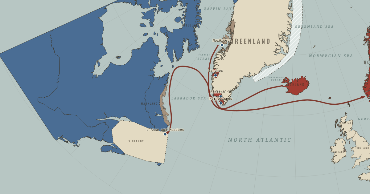
The map above is the world of The Norse North Atlantic, 1021 — Vinland: wood felled at L’Anse aux Meadows.
Part of IB History: The Norse and the Aztecs →
BRIEF EXPLANATION — THE ESSENTIAL ARGUMENT
Greenland was the boldest Norse colony, and it was possible only because the warm centuries made its sheltered southern fjords green enough for hay. In 985 or 986 Erik the Red, an outlaw from Iceland, led a fleet of 25 ships west, and 14 of them arrived. Their settlers founded two communities, the Eastern Settlement near Greenland’s southern tip and the smaller Western Settlement some 400 kilometres to the northwest, and farmed cattle, sheep and goats on meadows at the heads of the fjords. Farming alone could not pay for the iron, timber and grain the colony had to import, so its men sailed far up the west coast to hunt walrus, whose tusks were prized in Europe much as ivory from elephants was. On the map, the two settlements turn red and the northern hunting grounds of Norðrseta tan. A colony of farmers could survive in Greenland only by also becoming a colony of hunters and traders.
Greenland also carried the Norse to a new continent, and how quickly they left shows where their system’s reach ended. Sailors from Greenland reached North America around the year 1000. The Icelandic sagas call the new lands Helluland, Markland and Vinland, meaning flat-stone land, forest land and wine land, and a Norse base excavated at L’Anse aux Meadows in Newfoundland proves the voyages were real. Its timber was cut with metal tools in the year 1021, a date fixed by a burst of cosmic radiation recorded in the growth rings. Yet the Norse left within a few years, because Vinland lay too far from Greenland, the colony had too few people to hold it, and the land already belonged to Indigenous peoples who resisted the newcomers. The map shows this short reach as a tan point and a dashed outline, the most distant edge of an expansion that warmth had made possible and distance soon made impractical.
The full story
The Greenland colony was designed around hay, and its geography followed the meadows. The settlers built about 500 farms in the Eastern Settlement and perhaps 75–100 in the Western, most of them deep inside the fjords where summers were warmest and grass grew best, away from the cold fog of the outer coast. At its peak around 1200 the colony probably held about 2,000–2,500 people, though older estimates ran to 5,000. A farm’s wealth was measured in the number of cattle its byres, the stone-and-turf cattle sheds, could keep alive through eight winter months, so the whole community depended on the summer’s hay harvest. Erik’s own farm, Brattahlíð, stood at the head of a fjord on the best land, which is how leadership and good meadows came to coincide.
Walrus ivory gave the colony an export that farming could not. Each summer, men rowed and sailed some 800 kilometres north to Norðrseta, the hunting grounds around Disko Bay, and brought back tusks, hides for rope and sometimes polar-bear skins. Ancient DNA studied by Bastiaan Star and James Barrett shows that by the twelfth century almost all the walrus ivory reaching Europe came from Greenland, carved into chess pieces, crosses and book covers. In return the Greenlanders bought iron, timber, grain and church goods. This trade made a tiny colony part of Europe’s luxury economy, though it also tied the colony’s prosperity to the taste of distant buyers.
Vinland was the furthest reach of this expansion, and the evidence for it combines saga and spade. The sagas describe Leif Eriksson finding a land of grass, salmon and mild winters, and later expeditions trading and fighting with people they called Skrælings, a dismissive Norse word for the Indigenous inhabitants, probably ancestors of the Innu or Beothuk of Labrador and Newfoundland. In 1960 Helge Ingstad and Anne Stine Ingstad found the site at L’Anse aux Meadows, with eight buildings for perhaps 70–90 people. Butternuts found there grow no closer than New Brunswick, so the Norse explored at least into the Gulf of St Lawrence. In 2021 Margot Kuitems and colleagues dated three pieces of cut wood to 1021 from the cosmic-ray signal of 993, preserved 29 rings inside the bark. The site was occupied for only a few years, which shows that a colony of a few thousand could reach America but not stay there.
DEEP EXPLANATION — EVIDENCE & INTERPRETATION
Saga and spade: what each can prove
The two Vinland sagas disagree on almost everything except that the voyages happened, and archaeology has settled that point. The Saga of the Greenlanders and Erik the Red’s Saga were written in Iceland in the thirteenth century and disagree on who first sighted America, who led which voyage and where the Norse wintered. For most of the nineteenth century many scholars treated them as legend. Archaeology changed that in 1960, when the Ingstads followed the local guidance of George Decker to grassy mounds at L’Anse aux Meadows, and excavations from 1961 to 1968 and by Parks Canada from 1973 to 1976 uncovered Norse-style halls, iron rivets, a smithy and a bronze cloak pin. Birgitta Wallace argues that the site was a gateway base, used to repair ships and stage voyages further south, and possibly the saga’s Straumfjörður. The archaeology confirms that the voyages happened and roughly when, while the sagas still supply the motives, names and encounters that no excavation can recover. Each kind of source answers questions the other cannot, and a historian of Vinland needs both.
How a solar storm dated a Norse axe-cut
The precise year 1021 comes from a method that did not exist until the 2010s. In 2012 Japanese researchers led by Fusa Miyake found a sudden spike of radiocarbon in tree rings formed in 775, and later a second spike in the ring for 993, caused by intense bursts of cosmic radiation, probably from the sun. Because every tree alive at the time recorded the same spike in the same ring, the spike works as a fixed marker in any piece of wood that contains it. Margot Kuitems’s team found the 993 ring in three wooden objects from three different trees at L’Anse aux Meadows, each cut with a metal blade, and counted 29 more rings to the bark edge on all three. All three trees were felled in 1021. The date proves a Norse presence in that year without fixing the first arrival, which the sagas place around 1000. It also shows how natural science can turn a vague saga chronology into a single, checkable year.
Why the Norse did not stay in America
Explaining the abandonment of Vinland requires weighing several pressures, and historians give them different weight. Distance was fundamental, since L’Anse aux Meadows lay roughly 1,800 kilometres by sea from the Eastern Settlement, a voyage of weeks in open boats. Population mattered too, because a colony of perhaps 2,000 people could not spare enough settlers to found and defend a new society. The sagas stress conflict with the Skrælings, who traded furs for red cloth and milk but then attacked, and Wallace notes that the Norse had no decisive military advantage, since their iron weapons were few and Indigenous archers fought on home ground. Some scholars add that Greenland’s own needs, grassland and walrus, were already met closer to home. Vinland failed because a small society at the end of a long supply line met resistant, numerous inhabitants, which is a lesson about scale as much as about courage. The same arithmetic of distance and numbers would later weigh on Greenland itself.
Key places on the map
Why it happened
Warm summers greened the southern fjords. The colony’s timing fits the Medieval Climate Anomaly, when midge remains from Scoop Lake near the Eastern Settlement indicate summers about 1.5 °C warmer than in the centuries before and after. Warmer, longer summers allowed enough hay to grow at the heads of the fjords to keep cattle alive through the winter. Erik the Red was exploiting a climatic window that he could not have understood in those terms but could see in the grass.
Iceland was already full and divided. By the 980s Iceland’s best land had been claimed for two or three generations, and younger sons and newcomers found few opportunities. Feuds also drove men out, since Erik himself was outlawed twice for killings. Greenland offered empty grassland to people who had lost out in Iceland, and the 25 ships that sailed in 985 or 986, carrying perhaps several hundred people with their animals, show how many were willing to gamble.
A name chosen to attract settlers. According to the Icelandic sources, Erik called the new land Greenland because people would be more willing to go there if it had an attractive name. The story shows that founding a colony required persuasion as well as seamanship, much as a modern developer markets a new town. Erik needed enough families to make the settlement viable, and the name was part of his recruitment, as were the best meadows he kept for himself at Brattahlíð.
European demand for walrus ivory. Walrus ivory was valued in Europe for carving religious objects and games, especially when African elephant ivory was scarce. Greenland’s walrus grounds in Norðrseta offered a supply that no one else could reach, and ancient DNA shows that by the twelfth century almost all European walrus ivory came from there. This demand gave the colony a reason to exist beyond subsistence and paid for the imports its farms could not produce.
THE TURNING POINT
L’Anse aux Meadows, 1021. The cutting of timber at L’Anse aux Meadows in 1021 is the hinge of this chapter because it marks the furthest point the Norse system could reach and the moment it began to pull back. Europeans and Indigenous Americans met across the Atlantic five centuries before Columbus, which proves that the ship and the settler society of the North Atlantic were capable of reaching a new continent. The withdrawal within a few years shows the limit of that capability. Reach depended on technology, while staying depended on numbers, supply and the consent of the people already there.
What it changed
A colony locked into hay and ivory. With Vinland abandoned, Greenland’s economy settled into its long pattern of cattle and sheep on the fjord meadows, seals and caribou for food, and walrus hunting in the north for export. That combination worked for about three centuries, but it depended on summers warm enough for hay and on European demand for ivory, and Chapter 5 shows both beginning to fail after 1250.
Timber trips to Markland continue. The Greenlanders kept sailing to Markland, probably the forested coast of Labrador, for the timber that their treeless land lacked. Icelandic annals for 1347 record a small Greenland ship, crewed by 17 or 18 men, that had been to Markland and was driven by storms to Iceland. The contact with America therefore did not end in 1021, though it never again became settlement.
Greenland enters the Church and the crown. The colony grew into a recognisable part of Christian Europe. It received its own bishop at Garðar in 1126 and built about fourteen to seventeen churches, and in 1261 it accepted the authority of the Norwegian king. These ties brought priests, ships and goods but also made the colony dependent on decisions taken in Bergen and Trondheim, as Chapter 6 explains.
DISCUSSION QUESTION — Does the abandonment of Vinland show the limits of Norse innovation or the limits of Norse numbers?
The evidence points more strongly to numbers than to technology. The ships, seamanship and building skills on display at L’Anse aux Meadows were fully capable of crossing to America, repairing vessels there and housing 70–90 people through a winter, so their inventions were equal to the task. The limit was population, since Greenland itself held perhaps 2,000–2,500 people, too few to settle and defend a distant colony. The sagas also show that Indigenous peoples were numerous, organised and willing to fight, and that the Norse held no decisive advantage in weapons. Distance multiplied every one of these weaknesses. Historians who stress conflict and those who stress logistics are describing the same problem from two sides, since a larger colony could have absorbed both the losses and the long voyages. The transferable insight is that the reach of a technology can far outrun the size of the society using it, and expansion stops where numbers run out.
An interesting fact
According to the Saga of the Greenlanders, the first child of European parents born in the Americas was a boy named Snorri, born in Vinland to Gudrid Thorbjarnardóttir and her husband Thorfinn Karlsefni around 1010. The family returned to Iceland and farmed in the north, and the saga says that Gudrid, widowed, later made a pilgrimage to Rome before becoming a nun. The saga traces several Icelandic bishops among her descendants. Gudrid had travelled from Iceland to Greenland, Vinland, Norway and Rome, which makes her one of the most widely travelled people of her century.
Related
THE FREE PRINTABLE STUDY GUIDE
Join the Dispatch — a short welcome series, then a letter when a new atlas opens — and the printable study guide for Climate and Innovation is yours now, free.
NO TRACKING · YOUR ADDRESS IS USED FOR THE DISPATCH AND NOTHING ELSE · UNSUBSCRIBE ANYTIME