Historical map · 500
Map of the World in 500
In 500, the historical border data behind our interactive map draws 53 states, empires and other polities in the world. By the land they held , the largest were Alliance between Northern Wei and Rouran Khaganate, the Allegiance of Ostrogothic Kingdom to Eastern Roman Empire and Rouran Khaganate.
See this map live. The interactive map opens on the World in 500. Zoom in, move the year slider to watch the borders change, or ask the history guide a question and it draws the answer on the map.
OPEN 500 ON THE MAP →Ask the history guide about 500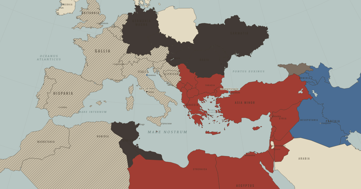
States and empires in the World in 500
| State | Territory | In the data |
|---|---|---|
| Alliance between Northern Wei and Rouran Khaganate Wikipedia | 6.2 million km² | 387–533 |
| Allegiance of Ostrogothic Kingdom to Eastern Roman Empire Wikipedia | 4.4 million km² | 500–560 |
| Rouran Khaganate Wikipedia | 3.8 million km² | 402–554 |
| White Huns Wikipedia | 3.3 million km² | 410–560 |
| Alliance between Gupta Empire and Vakataka Kingdom Wikipedia | 2.7 million km² | 324–554 |
| Southern Qi Wikipedia | 2.4 million km² | 480–509 |
| Sasanian Empire Wikipedia | 2.2 million km² | 215–643 |
| Eastern Roman Empire Wikipedia | 2.0 million km² | 31 BC–AD 632 |
| Visigothic Kingdom Wikipedia | 689,000 km² | 426–723 |
| Vakataka Kingdom Wikipedia | 673,000 km² | 260–554 |
| Tuyuhun Wikipedia | 554,000 km² | 287–665 |
| Protectorate of the Western Regions Wikipedia | 437,000 km² | 117–601 |
| Goguryeo Wikipedia | 408,000 km² | 36 BC–AD 681 |
| Mayan City-States Wikipedia | 380,000 km² | 247 BC–AD 1546 |
| Scandinavian minor kingdoms Wikipedia | 376,000 km² | 500–799 |
| Merovingian Empire Wikipedia | 362,000 km² | 462–989 |
| Himyarite Kingdom Wikipedia | 297,000 km² | 110 BC–AD 601 |
| Salian Franks Wikipedia | 277,000 km² | 358–509 |
| Lakhmid Kingdom Wikipedia | 259,000 km² | 270–633 |
| Brythonic Kingdoms Wikipedia | 258,000 km² | 439–1284 |
| Vandal Kingdom Wikipedia | 249,000 km² | 439–533 |
| Funan Wikipedia | 246,000 km² | 51–640 |
| Kadamba Empire Wikipedia | 203,000 km² | 353–554 |
| Nobatia Wikipedia | 148,000 km² | 347–655 |
| Maitraka Dynasty Wikipedia | 145,000 km² | 476–731 |
| Anglo-Saxon England Wikipedia | 144,000 km² | 441–935 |
| Kalabhra Dynasty Wikipedia | 138,000 km² | 353–601 |
| Kamarupa Kingdom Wikipedia | 130,000 km² | 353–1138 |
| Alodia Wikipedia | 124,000 km² | 347–1506 |
| Burgundian Kingdom Wikipedia | 119,000 km² | 154–660 |
| Pyu City-States Wikipedia | 117,000 km² | 84–1045 |
| Kingdom of Axum Wikipedia | 97,000 km² | 50 BC–AD 946 |
| Kingdom of the Suebi Wikipedia | 92,000 km² | 414–586 |
| Saxons Wikipedia | 82,000 km² | 283–799 |
| Caucasian Albania Wikipedia | 75,000 km² | 63 BC–AD 509 |
| Anurādhapura Wikipedia | 74,000 km² | 291 BC–AD 1017 |
| Chámpa Wikipedia | 73,000 km² | 207–1652 |
| Zapotec Civilization Wikipedia | 70,000 km² | 500 BC–AD 895 |
| Makuria Wikipedia | 65,000 km² | 347–1518 |
| Ripuarian Franks Wikipedia | 44,000 km² | 238–509 |
Also on the map: Kingdom of Thuringia, Late Pallava Empire, Caucasian Iberia, Baekje, Lazica, Silla, Tarumanagara, Lombards, Byeonhan, Teotihuacan, Kingdom of Sussex, Kingdom of Kent, Tamna.
"In the data" gives the first and last year the dataset draws the state under this identity; states often existed earlier or later in another form.
What changed since 400
New on the map: Allegiance of Ostrogothic Kingdom to Eastern Roman Empire, Rouran Khaganate, White Huns, Southern Qi, Visigothic Kingdom, Scandinavian minor kingdoms, Merovingian Empire, Brythonic Kingdoms, Vandal Kingdom, Maitraka Dynasty, Anglo-Saxon England, Burgundian Kingdom, Kingdom of the Suebi, Kingdom of Thuringia, Lombards, Kingdom of Sussex, Kingdom of Kent.
Gone from the map: Allegiance of Kidarites to Sasanian Empire, Western Jin, Western Roman Empire, Huns, Western Satraps, Xionites, Later Yan, Later Qin, Northern Liang, Western Qin, Later Liang, Visigoths, Wusun, Vandals, Southern Liang, Norse, Angles.
What comes next: 600
Appear by 600: Western Göktürks, Sui Dynasty, Avar Khaganate, Maukhari Dynasty, Yenisei Kyrgyz, Chenla, Ghassanids, Asuka Japan, Chalukya Dynasty, Kingdom of Italy, Turk Shahis, Karkota Dynasty, Early Lý Dynasty, Bavarians, Pandya Dynasty, Duchy of Thuringia, Breton Kingdoms, Kingdom of Mercia, Dál Riata, Kingdom of Wessex, Kingdom of Deira, Kingdom of East Anglia, Kingdom of Rheged, Kingdom of Bernicia, Kingdom of Gwynedd, Kingdom of Powys, Classic Veracruz Culture, Hwicce, Kingdom of Essex, Kingdom of Lindsey and others.
Gone by 600: Alliance between Northern Wei and Rouran Khaganate, Allegiance of Ostrogothic Kingdom to Eastern Roman Empire, Rouran Khaganate, White Huns, Alliance between Gupta Empire and Vakataka Kingdom, Southern Qi, Vakataka Kingdom, Salian Franks, Vandal Kingdom, Kadamba Empire, Burgundian Kingdom, Kingdom of the Suebi, Caucasian Albania, Ripuarian Franks, Kingdom of Thuringia, Caucasian Iberia, Lazica, Lombards, Byeonhan.
Read the history of 500
Guided atlas chapters set near this date, each with its own map, causes and consequences:
- Why Rome Fell — and What SurvivedRome · chapter 12 · AD 481
Questions about this map
Which countries were in the World in 500?
The map data draws 53 states and other polities in the World in 500. The largest by land were Alliance between Northern Wei and Rouran Khaganate, the Allegiance of Ostrogothic Kingdom to Eastern Roman Empire, Rouran Khaganate, White Huns and the Alliance between Gupta Empire and Vakataka Kingdom.
What was the largest empire in the world in 500?
Of the states on this map, Alliance between Northern Wei and Rouran Khaganate held the most land in total: about 6.2 million km² in the reconstruction used here. Ancient and frontier borders are approximate, so treat areas as estimates.
Can I explore the World in 500 interactively?
Yes. Open the interactive map at 500, zoom into any region, move through the years, and ask the history guide questions: it answers in plain words and draws places, armies and borders on the map.
About these borders
The borders come from Cliopatria (v0.2.1, Seshat Global History Databank, CC BY 4.0), the dataset behind our interactive map, with our audited name and border corrections. It records each state's territory year by year from 3400 BC to 2024. Borders before modern surveys are reconstructions: the data draws a state where it held control, and frontier zones, nomadic realms and loose overlordships are approximate. Areas are measured on an equal-area projection. Read how we make our maps.
World in other years
- 3000 BC
- 2000 BC
- 1500 BC
- 1000 BC
- 750 BC
- 500 BC
- 323 BC
- 200 BC
- 100 BC
- AD 1
- 100
- 200
- 300
- 400
- 500
- 600
- 700
- 800
- 900
- 1000
- 1100
- 1200
- 1300
- 1400
- 1444
- 1453
- 1492
- 1500
- 1550
- 1600
- 1648
- 1700
- 1750
- 1776
- 1789
- 1800
- 1815
- 1830
- 1850
- 1871
- 1880
- 1900
- 1910
- 1914
- 1918
- 1920
- 1930
- 1938
- 1939
- 1940
- 1942
- 1945
- 1950
- 1960
- 1970
- 1980
- 1990
- 2000
- 2010
- 2020