Historical map · 1815
Map of the World in 1815
In 1815, the historical border data behind our interactive map draws 137 states, empires and other polities in the world. By the land they held , the largest were the Spanish Empire, the Russian Empire and the Portuguese Empire.
See this map live. The interactive map opens on the World in 1815. Zoom in, move the year slider to watch the borders change, or ask the history guide a question and it draws the answer on the map.
OPEN 1815 ON THE MAP →Ask the history guide about 1815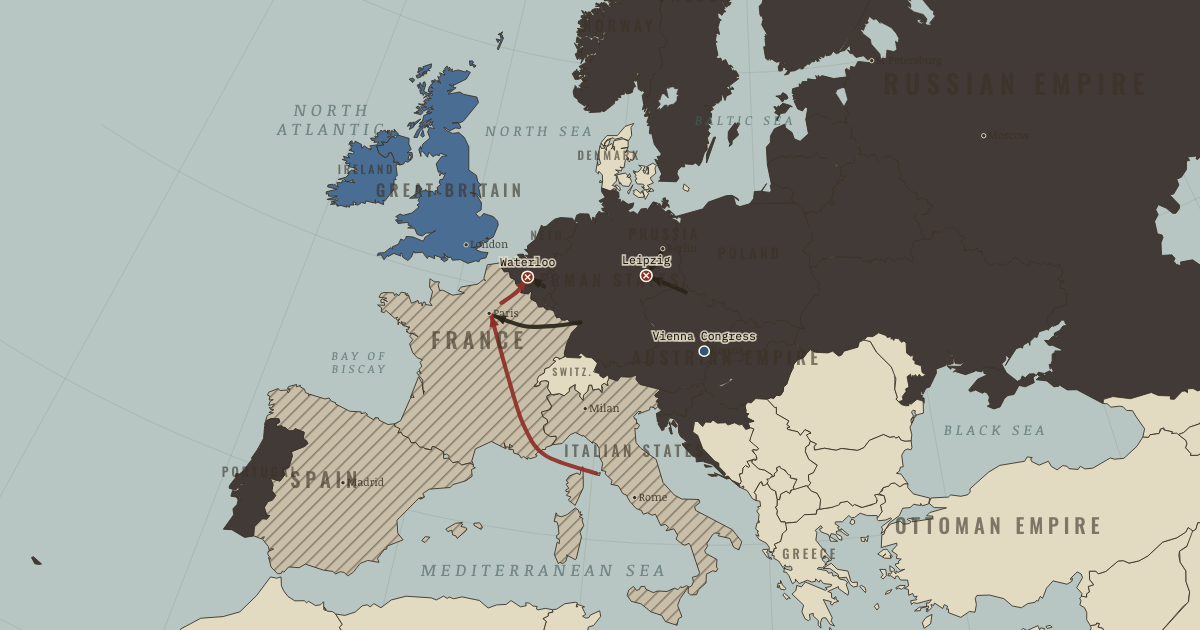
States and empires in the World in 1815
| State | Territory | In the data |
|---|---|---|
| Spanish Empire Wikipedia | 17.6 million km² | 1516–1931 |
| Russian Empire Wikipedia | 17.3 million km² | 1721–1916 |
| Portuguese Empire Wikipedia | 15.8 million km² | 1502–1910 |
| Qing Dynasty Wikipedia | 12.5 million km² | 1645–1911 |
| British Empire Wikipedia | 6.2 million km² | 1706–1999 |
| Company rule in India (British East India Company) | 3.4 million km² | 1811–1819 |
| Ottoman Empire Wikipedia | 2.2 million km² | 1305–1923 |
| Kazakh Khanate Wikipedia | 1.8 million km² | 1468–1847 |
| Qajar Iran Wikipedia | 1.7 million km² | 1788–1923 |
| United States of America Wikipedia | 1.6 million km² | 1776–2024 |
| Durrani Empire Wikipedia | 1.6 million km² | 1748–1827 |
| Kingdom of France (Bourbon Restoration) Wikipedia | 1.3 million km² | 990–1848 |
| Emirate of Diriyah Wikipedia | 968,000 km² | 1744–1819 |
| Río de la Plata Wikipedia | 907,000 km² | 1811–1833 |
| Maratha Empire Wikipedia | 857,000 km² | 1677–1845 |
| United Kingdoms of Sweden and Norway Wikipedia | 799,000 km² | 1815–1904 |
| Khanate of Khiva Wikipedia | 737,000 km² | 1512–1919 |
| Austrian Empire Wikipedia | 689,000 km² | 1806–1867 |
| Konbaung Dynasty Wikipedia | 678,000 km² | 1741–1819 |
| Funj Sultanate Wikipedia | 629,000 km² | 1507–1821 |
| Sokoto Caliphate Wikipedia | 617,000 km² | 1805–1904 |
| Muhammad Ali dynasty Wikipedia | 606,000 km² | 1805–1865 |
| Federal League Wikipedia | 606,000 km² | 1814–1819 |
| New Granada Wikipedia | 605,000 km² | 1811–1821 |
| Kingdom of Spain Wikipedia | 495,000 km² | 1516–2024 |
| Netherlands Wikipedia | 469,000 km² | 1811–2024 |
| Siam Wikipedia | 432,000 km² | 1783–1931 |
| Morocco Wikipedia | 388,000 km² | 1670–2024 |
| Emirate of Bukhara Wikipedia | 368,000 km² | 1788–1919 |
| Tokugawa Shogunate Wikipedia | 363,000 km² | 1600–1869 |
| United Kingdom Wikipedia | 342,000 km² | 1709–2024 |
| German Confederation Wikipedia | 341,000 km² | 1815–1867 |
| Dutch East Indies Wikipedia | 327,000 km² | 1800–1949 |
| Paraguay Wikipedia | 323,000 km² | 1811–2024 |
| Mexican insurgents (War of Independence) | 312,000 km² | 1811–1819 |
| Nguyễn dynasty Wikipedia | 298,000 km² | 1791–1884 |
| Sultanate of Darfur Wikipedia | 296,000 km² | 1609–1876 |
| British Cape Colony Wikipedia | 283,000 km² | 1796–1884 |
| Wadai Empire Wikipedia | 281,000 km² | 1636–1910 |
| Ethiopian Empire Wikipedia | 241,000 km² | 1272–1935 |
Also on the map: Mughal Empire, Joseon, Bornu Empire, Regency of Algiers, Denmark, Khanate of Kokand, Vientiane, Sultanate of Johor, Ashanti Empire, Nepal, Kingdom of Luang Phrabang, Kingdom of Cambodia, Merina Kingdom, Kingdom of Lunda, Bamana Empire, Greenland, Kingdom of Portugal, Imamate of Yemen, Kingdom of the Two Sicilies, Oyo Empire, Beylik of Tunis, Kingdom of Sardinia, Karamanli Dynasty, Sultanate of Oman, Sultanate of Palembang, Principality of Wallachia, Kingdom of Bavaria, Sultanate of Brunei, Sultanate of Sulu, Chiangmai, Omani East Africa (Swahili coast), Sikh Empire, Kingdom of Champasak, Sultanate of Aceh, Principality of Moldavia, Serbia, Bhutan, Swiss Confederation, Sultanate of Malacca, Sultanate of Banjar, Papal States, Haiti, Sultanate of Jambi, Kingdom of Hawaiʻi, Sultanate of Perak, Kingdom of Württemberg, Grand Duchy of Berg, Sultanate of Terengganu, Grand Duchy of Baden, Sultanate of Selangor, Sultanate of Sukadana, Sultanate of Kedah, Grand Duchies of Mecklenburg, Electorate of Hesse, Sultanate of Bima, Principality of Abkhazia, Dutch Gold Coast, Kelantan, Grand Duchy of Hesse, Bali, Duchy of Parma and Piacenza, Duchy of Modena and Reggio, Sultanate of Kutai Kartanegara, Negeri Sembilan, Sultanate of Sambas, Kuwait, Duchy of Nassau, Duchy of Oldenburg, Duchy of Brunswick, Yogyakarta Sultanate, Pontianak Kadriyah Sultanate, Principality of Guria, Surakarta Sunanate, Đại Việt, French India, Principality of Reuss-Gera, Septinsular Republic, Sultanate of Mempawah, Free City of Lübeck, Grand Duchy of Saxe-Weimar-Eisenach, Principality of Svaneti, Netherlands Antilles, Sultanate of Bone, Saxe-Altenburg, Free City of Krakow, Duchy of Anhalt, Principality of Hohenzollern-Sigmaringen, Principality of Waldeck and Pyrmont, Grand Duchy of Tuscany, House of Khalifa, Free City of Hamburg, Principality of Lippe, Danish Gold Coast, Kingdom of Prussia, Principality of Andorra, Sultanate of Maguindanao, Free City of Bremen.
"In the data" gives the first and last year the dataset draws the state under this identity; states often existed earlier or later in another form.
What changed since 1800
New on the map: Company rule in India (British East India Company), Kingdom of France (Bourbon Restoration), Río de la Plata, United Kingdoms of Sweden and Norway, Austrian Empire, Sokoto Caliphate, Muhammad Ali dynasty, Federal League, New Granada, Netherlands, German Confederation, Paraguay, Mexican insurgents (War of Independence), Imamate of Yemen, Kingdom of the Two Sicilies, Kingdom of Bavaria, Omani East Africa (Swahili coast), Serbia, Swiss Confederation, Kingdom of Württemberg, Grand Duchy of Berg, Grand Duchy of Baden, Grand Duchies of Mecklenburg, Electorate of Hesse, Grand Duchy of Hesse, Duchy of Parma and Piacenza, Duchy of Modena and Reggio, Duchy of Nassau, Duchy of Oldenburg, Duchy of Brunswick and others.
Gone from the map: Habsburg Monarchy, French Consulate, Swedish Empire, Batavian Republic, Holy Roman Empire, Tây Sơn dynasty, Qasimids, Carnatic Sultanate, Nawab of Awadh, Kingdom of Naples (Napoleonic), Sultanate of Banten, Kingdom of Georgia, French Louisiana, Duchy of Bavaria, Helvetic Republic, Electorate of Saxony, Electorate of Hanover, British Ceylon, Kingdom of Imereti, Cispadane Republic, Sikh Confederacy, Principality of Mingrelia, Republic of Ragusa, New Netherland, Danish India, County of Urgell.
What comes next: 1830
Appear by 1830: Empire of Brazil, United Mexican States (federal republic), Gran Colombia, Bolivia, Republic of Peru, Emirate of Afghanistan, Emirate of Nejd, Burma, Talpur Dynasty, United Provinces of Central America, Republic of Chile, Oriental Republic of Uruguay, Surinam (Dutch colony), Polish insurgents (November Uprising), Massina Empire, Riau-Lingga Sultanate, Trucial States, Greece, Caucasian Imamate, Zululand, Kingdom of Belgium, Qatar, Kingdom of Saxony, Sultanate of Sambaliung, French Algeria, Saxe-Meiningen, Principality of Schwarzburg-Sonderhausen.
Gone by 1830: Company rule in India (British East India Company), Durrani Empire, Emirate of Diriyah, Konbaung Dynasty, Funj Sultanate, Federal League, New Granada, Mexican insurgents (War of Independence), Vientiane, Bamana Empire, Sultanate of Palembang, Principality of Wallachia, Principality of Moldavia, Grand Duchy of Berg, Sultanate of Kedah, Principality of Abkhazia, Sultanate of Sambas, Yogyakarta Sultanate, Pontianak Kadriyah Sultanate, Principality of Guria, Surakarta Sunanate, Septinsular Republic, Sultanate of Mempawah, Netherlands Antilles.
Read the history of 1815
Guided atlas chapters set near this date, each with its own map, causes and consequences:
- The FallThe Age of Revolutions · chapter 9 · JUN 1815
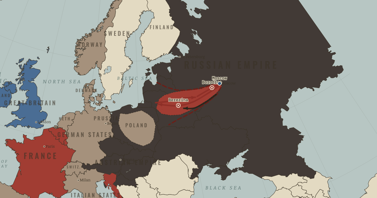 1812: The Russian CampaignThe Age of Revolutions · chapter 8 · SEP 1812
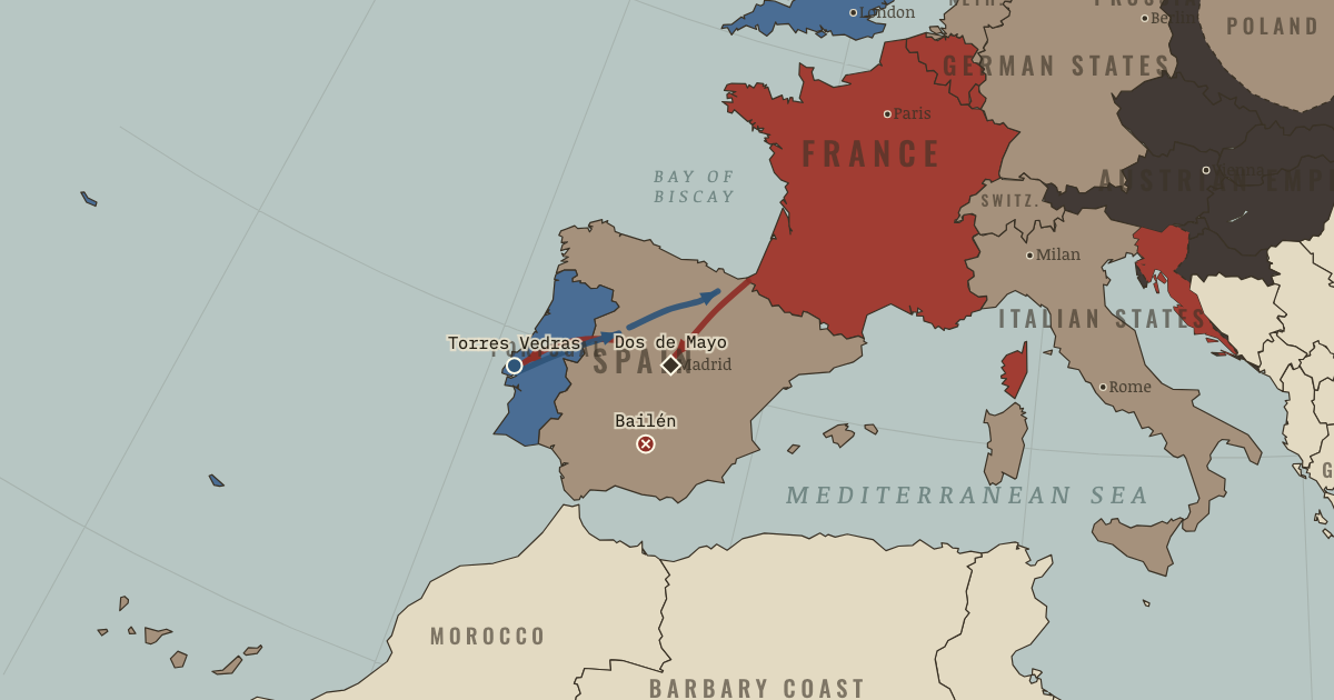 The Empire and Its CracksThe Age of Revolutions · chapter 7 · JUN 1810
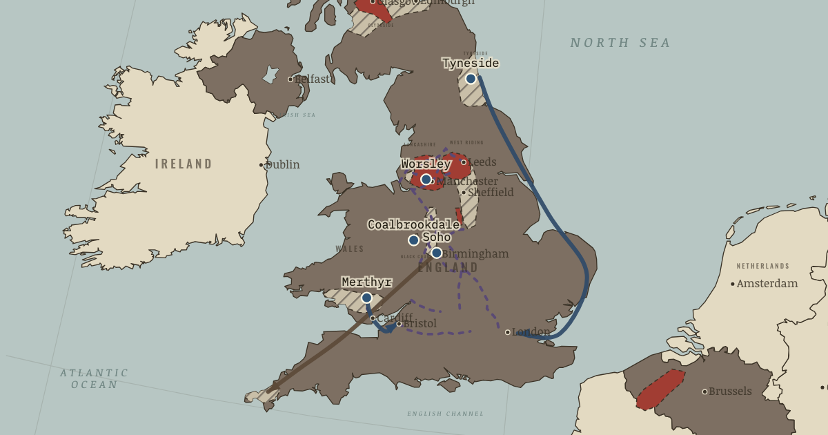 Steam, Coal and IronThe Industrial Revolution · chapter 3 · 1820
Questions about this map
Which countries were in the World in 1815?
The map data draws 137 states and other polities in the World in 1815. The largest by land were the Spanish Empire, the Russian Empire, the Portuguese Empire, the Qing Dynasty and the British Empire.
What was the largest empire in the world in 1815?
Of the states on this map, the Spanish Empire held the most land in total: about 17.6 million km² in the reconstruction used here. Ancient and frontier borders are approximate, so treat areas as estimates.
Can I explore the World in 1815 interactively?
Yes. Open the interactive map at 1815, zoom into any region, move through the years, and ask the history guide questions: it answers in plain words and draws places, armies and borders on the map.
About these borders
The borders come from Cliopatria (v0.2.1, Seshat Global History Databank, CC BY 4.0), the dataset behind our interactive map, with our audited name and border corrections. It records each state's territory year by year from 3400 BC to 2024. Borders before modern surveys are reconstructions: the data draws a state where it held control, and frontier zones, nomadic realms and loose overlordships are approximate. Areas are measured on an equal-area projection. Read how we make our maps.
World in other years
- 3000 BC
- 2000 BC
- 1500 BC
- 1000 BC
- 750 BC
- 500 BC
- 323 BC
- 200 BC
- 100 BC
- AD 1
- 100
- 200
- 300
- 400
- 500
- 600
- 700
- 800
- 900
- 1000
- 1100
- 1200
- 1300
- 1400
- 1444
- 1453
- 1492
- 1500
- 1550
- 1600
- 1648
- 1700
- 1750
- 1776
- 1789
- 1800
- 1815
- 1830
- 1850
- 1871
- 1880
- 1900
- 1910
- 1914
- 1918
- 1920
- 1930
- 1938
- 1939
- 1940
- 1942
- 1945
- 1950
- 1960
- 1970
- 1980
- 1990
- 2000
- 2010
- 2020