MAPS OF HISTORY · IB HISTORY · PAPER 1 · CLIMATE AND INNOVATION
IB HISTORY · PAPER 1 · FOCUSED STUDY
Paper 1: Climate and Innovation — Norse world and Aztec Empire
Climate and Innovation is one of the five Paper 1 Focused Studies of the new IB History course, first examined in May 2028. Paper 1 is the source paper: its questions ask you to read primary sources closely, to judge what each can and cannot tell a historian, and to combine them with your own knowledge. This Focused Study pairs two case studies, Norse world and Aztec Empire, and our atlas Climate and Innovation covers both on linked maps, in 12 chapters with 46 primary sources.
Two societies, two demanding climates: Norse farmers who sailed to Greenland in the warm centuries and left as the cold returned, and the Mexica, who turned a salty lake into a city of 200,000.
WW2 is free — every chapter. Try chapters 1–2 of any 2 other atlases (3 with a free account). Opening a new atlas uses one of them. Membership opens all 21 — Join.
What this Focused Study asks
Each source set in the atlas is built around one inquiry question, and together they show what this Focused Study asks of you. Keep them in mind as you read: a good answer to any of them needs both the sources and the chapters behind them.
Norse world
- How far do the sagas and archaeology agree about the Norse voyages to North America?
- How did the first Icelanders adapt their society to a new land?
- What do the sources reveal about how the Norse in Greenland experienced and responded to a cooling climate?
Aztec Empire
- How did the Mexica respond to the frost, drought and floods of the fifteenth century?
- What do the sources reveal about how Tenochtitlan was fed and supplied?
- Why did Tenochtitlan fall in 1521, according to the sources?
Case study 1: Norse world
Chapters 2–6 of the atlas follow Norse world, from 790 to 1450. Read them in order: each chapter is a step in one argument, and the map moves with it.
- The Ship and the Sea RoadCHAPTER 2 · c. 790–900
- Iceland: A Society on a Volcanic IslandCHAPTER 3 · 870–1000
- Greenland and VinlandCHAPTER 4 · 985–1050
- Living with the ColdCHAPTER 5 · 1250–1450
- What the Norse LeftCHAPTER 6 · c. 1100–1450
Evidence to use
One point from the IB notes of each chapter, written as a sentence you could use in an answer. Every chapter in the atlas carries four to six.
- The Oseberg ship, built around 820 and buried in 834, was 21.5 metres long with fifteen pairs of oars, and its clinker hull of overlapping riveted planks flexed with the waves while drawing only about a metre of water. CH 2
- Íslendingabók, written by Ari Þorgilsson in the 1120s, says that Iceland was settled within sixty winters and was wooded “between fell and fore-shore”, evidence that the settlers remembered a very different landscape. CH 3
- Erik the Red led 25 ships from Iceland to Greenland in 985 or 986, of which 14 arrived, and the settlers built about 500 farms in the Eastern Settlement and 75–100 in the Western in the warm inner fjords. CH 4
- Bone chemistry from 123 Norse skeletons shows that food from the sea rose from roughly 15–50 percent of the diet in the early colony to 50–80 percent by the fourteenth century, so the Greenlanders met the cold by eating far more seal. CH 5
- Fish bones from English sites show a sudden rise in sea fish around the year 1000, which James Barrett calls the fish event horizon, and isotope studies trace much of the later cod to northern Norway, home of the stockfish trade. CH 6
Case study 2: Aztec Empire
Chapters 7–11 of the atlas follow Aztec Empire, from 1325 to 1521. Read them in order: each chapter is a step in one argument, and the map moves with it.
- An Empire Built on a LakeCHAPTER 7 · 1325–1428
- Water: Dikes, Aqueducts and FloodsCHAPTER 8 · 1428–1500
- Chinampas: Feeding a CityCHAPTER 9 · c. 1430–1519
- The Planned CityCHAPTER 10 · c. 1430–1519
- The Flower Wars and the End of the SystemCHAPTER 11 · 1450s–1521
Evidence to use
One point from the IB notes of each chapter, written as a sentence you could use in an answer. Every chapter in the atlas carries four to six.
- The Basin of Mexico covers roughly 7,500–9,600 square kilometres at about 2,240 metres, and at high water its linked lakes spread over some 1,000–1,500 square kilometres, salty in the east at Texcoco and fresh in the south. CH 7
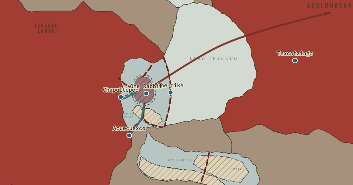
- After the flood usually dated to 1449, Nezahualcoyotl designed a dike of stone, clay and stakes some 12–16 kilometres long from Atzacoalco to Iztapalapa, built by workers drawn from Tlacopan, Culhuacan, Iztapalapa, Tenayuca and Xochimilco. CH 8
- Chinampas were built by piling lake mud and vegetation inside plots staked out in shallow fresh water and anchoring their edges with ahuejote willows, which gave moist, fertile beds that could carry several crops a year. CH 9
- The sacred precinct at the heart of Tenochtitlan measured roughly 430–460 metres across, and Sahagún’s informants listed 78 structures within it, dominated by the twin shrines of the Templo Mayor to Huitzilopochtli and Tlaloc. CH 10
- According to Alva Ixtlilxochitl, the Triple Alliance agreed in 1454 to fight Tlaxcala, Huexotzinco and Cholula in ritual flower wars for captives, while Ross Hassig reads these wars as attrition and Barry Isaac as cover for a failure to conquer. CH 11
Comparing the two case studies
The atlas ends by setting the two case studies side by side in Two Answers to the Environment. Comparison is where the Focused Study pays off: the same question asked of two societies shows which explanations travel and which belong to one place.
PAPER 2 · CLIMATE AND INNOVATION · CHAPTER 12
Compare and contrast the ways in which the Norse in Greenland and the Mexica in the Basin of Mexico responded to the challenges of their environments.
Both societies built systems of innovation to live with demanding climates, and both depended on trade or tribute from beyond their homelands. They differed in scale and strategy: the Norse answered a scattered environment with mobility and adaptation, the Mexica a concentrated one with engineering and empire, and those differences shaped how each system ended.
Both used innovation to extend the limits of farming.
Both depended on resources from beyond home.
They differed sharply in scale and in how they ended.
The evidence for each point, the counter-argument and the judgement are in the IB notes of chapter 12 in the atlas. Read the chapter first: Two Answers to the Environment.
Key concepts
The course asks you to think with six concepts. Each chapter’s IB notes name the two or three it supports best; here they are across the atlas, most used first.
- Significance · 8 CHAPTERS
Why an event, person or idea matters, judged by its effects and by how it has been remembered. For example: Climate as a Force in History, The Ship and the Sea Road, Greenland and Vinland, What the Norse Left. - Causation · 7 CHAPTERS
Why something happened: the long-term conditions, the triggers and the choices behind it, and which of them mattered most. For example: Climate as a Force in History, The Ship and the Sea Road, Greenland and Vinland, Living with the Cold. - Change · 7 CHAPTERS
What was different afterwards, how quickly it changed, and for whom. For example: The Ship and the Sea Road, Iceland: A Society on a Volcanic Island, Living with the Cold, What the Norse Left. - Perspectives · 7 CHAPTERS
How people at the time, and historians since, have seen the same events differently, and why. For example: Climate as a Force in History, Iceland: A Society on a Volcanic Island, Greenland and Vinland, Living with the Cold. - Consequence · 5 CHAPTERS
What followed from an event or decision, intended and unintended, in the short and the long term. For example: Iceland: A Society on a Volcanic Island, Water: Dikes, Aqueducts and Floods, Chinampas: Feeding a City, The Flower Wars and the End of the System. - Continuity · 2 CHAPTERS
What stayed the same through an apparent upheaval, and why it survived. For example: What the Norse Left, Two Answers to the Environment.
Source-analysis practice
This is one complete source set from the atlas, free to use. It is built around one inquiry question: How far do the sagas and archaeology agree about the Norse voyages to North America? Read the sources first and note who made each one, when and why. Then answer the questions in writing, and only afterwards open the guide under each question, which describes what a strong answer does.
TEXT · CHAPTER 4
The Saga of the Greenlanders on Leif’s winter in Vinland
- CREATOR
- Anonymous Icelandic author
- DATE
- Thirteenth century (copied in Flateyjarbók, 1387–94)
- ORIGIN
- Grænlendinga saga (The Saga of the Greenlanders)
Context. The two Vinland sagas disagree on who first reached America and where the voyagers wintered; this saga gives the lead role to Leif Eriksson.
Translation: A.M. Reeves, The Finding of Wineland the Good (London: Henry Frowde, 1890), pp. 65–66. · original ↗
TEXT · CHAPTER 4
The Saga of the Greenlanders on trade with the Skrælings
- CREATOR
- Anonymous Icelandic author
- DATE
- Thirteenth century (copied in Flateyjarbók, 1387–94)
- ORIGIN
- Grænlendinga saga, the expedition of Thorfinn Karlsefni
Context. “Skrellings” was the Norse name for the Indigenous peoples they met; the passage is told entirely from the Norse point of view.
Translation: A.M. Reeves, The Finding of Wineland the Good (London: Henry Frowde, 1890), p. 73. · original ↗
PICTURE · CHAPTER 4
Reconstructed Norse buildings at L’Anse aux Meadows
- CREATOR
- Photograph by Eric Titcombe
- DATE
- 2013 (reconstructions built by Parks Canada)
- ORIGIN
- L’Anse aux Meadows National Historic Site, Newfoundland
Context. The buildings are modern reconstructions beside the excavated originals, which were found in 1960 and excavated in 1961–68 and 1973–76.
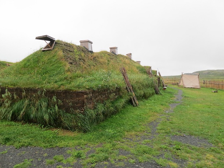
Eric Titcombe, “L’Anse aux Meadows - Exterior of reconstructed Viking house”, CC BY 2.0, via Wikimedia Commons. · original ↗
PICTURE · CHAPTER 1
The opening of the Saga of the Greenlanders in Flateyjarbók
- CREATOR
- Scribes Jón Þórðarson and Magnús Þórhallsson
- DATE
- 1387–1394
- ORIGIN
- Manuscript page, GKS 1005 fol., Árni Magnússon Institute for Icelandic Studies, Reykjavík
Context. Flateyjarbók was written in Iceland almost four centuries after the voyages to Greenland and Vinland that this saga describes.
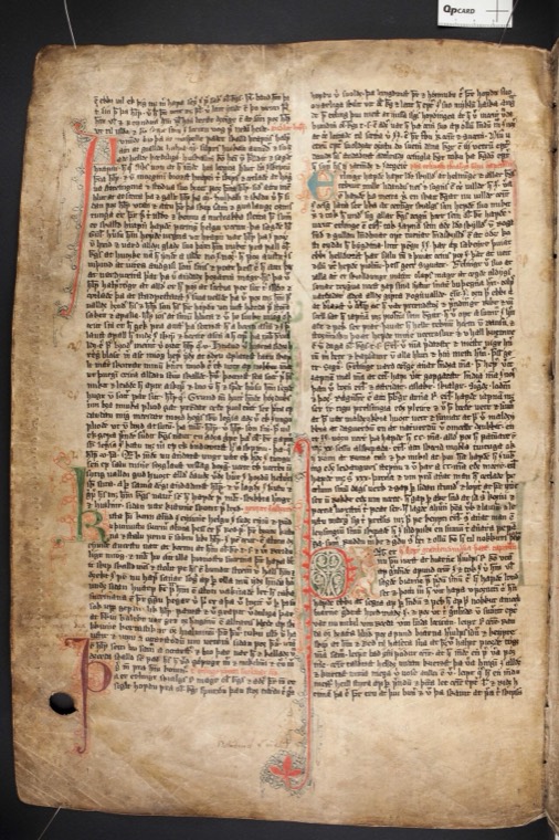
Flateyjarbók, GKS 1005 fol., Árni Magnússon Institute; image via Wikimedia Commons (public domain). · original ↗
The questions
- QUESTION 1 · COMPREHENSION
According to Source A, what did Leif’s crew find attractive about the land where they wintered?
What a strong answer does
A strong answer picks out three distinct points from the text: the salmon in the river and lake, larger than any the crew had seen; the mild winters, in which cattle would need no fodder and there was no frost; and the more equal length of day and night. It uses short quotations and does not add knowledge from outside the source.
- Gives three separate points from the source
- Uses brief quotation or close paraphrase
- Stays within the source
- QUESTION 2 · ANALYSIS
What does Source C suggest about the Norse presence at L’Anse aux Meadows?
What a strong answer does
The photograph shows low turf-walled halls on open, treeless ground beside the sea. A strong answer infers that the buildings were sturdy, built for winter and for a group of some size, using local turf in the Icelandic and Greenlandic manner. It notes that these are modern reconstructions beside the excavated originals, so they show an interpretation of the evidence.
- Makes inferences from what is visible
- Links the building style to the Norse homeland
- Notes that the buildings are reconstructions
- QUESTION 3 · EVALUATION
With reference to its origin, purpose and content, assess the value and limitations of Source D for a historian studying the Norse voyages west.
What a strong answer does
Source D is a page of Flateyjarbók, written in Iceland in 1387–94, almost four centuries after the voyages. Its value lies in preserving the Saga of the Greenlanders, the fuller of the two Vinland sagas, and in showing how fourteenth-century Icelanders recorded their past. Its limitations follow from the gap in time, oral transmission and the aim of honouring Icelandic families descended from the explorers.
- Uses origin, purpose and content explicitly
- Gives at least one value and one limitation
- Links each point to the question
- QUESTION 4 · SYNTHESIS
Using the sources and your own knowledge, evaluate the claim that the Norse settlement in North America failed because it was too far from home.
What a strong answer does
A strong answer builds a balanced argument. Distance mattered: L’Anse aux Meadows lay about 1,800 kilometres from the Eastern Settlement, and Greenland had perhaps 2,000–2,500 people to spare. Sources A and B show other factors, the attractions of the land and an uneasy relationship with Indigenous peoples, while Source C shows a base built for a few years. The judgement weighs distance against population and conflict, using the 1021 tree-ring date as evidence.
- Uses at least three of the sources
- Adds accurate own knowledge
- Weighs distance against other factors
- Reaches a clear judgement
More source sets in the atlas
The atlas holds 5 more source sets for this Focused Study. Their sources sit in the IB notes of the chapters named below: open a chapter in the atlas and turn on the IB notes switch to read them.
- How did the first Icelanders adapt their society to a new land? NORSE WORLD
Its sources are in the IB notes of chapter 3. - What do the sources reveal about how the Norse in Greenland experienced and responded to a cooling climate? NORSE WORLD
Its sources are in the IB notes of chapter 1, chapter 5. - How did the Mexica respond to the frost, drought and floods of the fifteenth century? AZTEC EMPIRE
Its sources are in the IB notes of chapter 1, chapter 8. - What do the sources reveal about how Tenochtitlan was fed and supplied? AZTEC EMPIRE
Its sources are in the IB notes of chapter 9. - Why did Tenochtitlan fall in 1521, according to the sources? AZTEC EMPIRE
Its sources are in the IB notes of chapter 11.
Practice questions and essay plans
Each question below comes with the outline of a model plan: a thesis that answers the question and the claim each paragraph makes. Try your own plan before you read ours. The first plan comes from chapter 2, a free chapter, and is shown in full. The full plans, with evidence, a counter-argument and a judgement, are in the chapters’ IB notes in the atlas, and the atlas’s own page lists every chapter’s notes: IB notes for The Norse and the Aztecs.
PAPER 2 · CLIMATE AND INNOVATION · CHAPTER 2
Evaluate the importance of technological innovation in causing the Viking expansion of the late eighth and ninth centuries.
The longship was a necessary precondition of the Viking expansion, but it explains how the Norse travelled more fully than why they set out. Social pressures at home and the pull of silver and trade abroad turned an existing technology into a movement, so innovation mattered mainly as the enabler of forces that were already building.
The clinker ship made raiding and settlement physically possible.
EVIDENCEShips like Oseberg, buried in 834, and Gokstad, built around 890, were light, flexible and drew only about a metre of water, so crews could cross the North Sea, row up rivers and beach anywhere without a harbour.
LINKWithout this vessel the surprise raid on Lindisfarne in 793 and the settlement of the islands could not have happened.
Social pressure at home supplied the motive for raiding.
EVIDENCEJames Barrett in 2008, and Raffield, Price and Collard in 2017, argue that a surplus of young men without land or the payment due to a bride’s family made risky raiding attractive in a country where only about 3 percent of the land can be ploughed.
LINKShips existed before 793, so the timing points to social change as the trigger.
Silver and trade supplied the pull.
EVIDENCEHundreds of thousands of Islamic dirhams have been found in Scandinavia, the trading towns of Kaupang and Hedeby were thriving, and around 890 Ohthere told King Alfred of walrus ivory and of furs taken as tribute from the Sámi.
LINKWealth abroad gave chieftains a reason to send ships out year after year.
One could argue that technology was the decisive factor, since the sail reached Scandinavia only around the seventh or eighth century. Lise Bender Jørgensen shows that a warship’s woollen sail took more than 1.5 tonnes of wool and decades of women’s labour, and its arrival transformed what ships could do just before the raids began.
Technology was the indispensable means, and the arrival of the sail helps explain the timing of the raids. Yet the social and economic forces that made Norse society willing to invest decades of labour in a single sail were the deeper cause, so innovation mattered as one part of a wider system of ambition, trade and status.
Read the chapter behind this plan: The Ship and the Sea Road.
PAPER 2 · CLIMATE AND INNOVATION · CHAPTER 5
To what extent was climate change the main reason for the abandonment of Norse Greenland?
Climate change was a necessary part of the explanation but not sufficient on its own. Cooling and drying narrowed the margin for cattle farming, yet the colony left only when economic decline and isolation struck at the same time, and the Inuit survived the same cold, so climate worked through the colony’s weaknesses.
Cooling and drying damaged the farming base.
The Norse adapted, which limits a purely climatic explanation.
Economic decline and isolation removed the colony’s purpose.
The evidence for each point, the counter-argument and the judgement are in the IB notes of chapter 5 in the atlas. Read the chapter first: Living with the Cold.
PAPER 2 · CLIMATE AND INNOVATION · CHAPTER 9
Examine the importance of the chinampas and the tribute system in sustaining the population of Tenochtitlan.
The chinampas and the tribute system were both essential, and they worked as parts of one supply system. The chinampas supplied fresh food close to the city at high yields, while tribute brought staples in bulk and goods from other climates; neither alone could have fed a city of perhaps 200,000.
The chinampas gave the city a productive local base.
Tribute supplied staples and spread risk across climates.
The market of Tlatelolco joined both systems together.
The evidence for each point, the counter-argument and the judgement are in the IB notes of chapter 9 in the atlas. Read the chapter first: Chinampas: Feeding a City.
PAPER 2 · CLIMATE AND INNOVATION · CHAPTER 11
To what extent was Indigenous opposition to the Mexica the main reason for the fall of Tenochtitlan in 1521?
Indigenous opposition was the main reason for the fall of Tenochtitlan, because it supplied the army, the base and the local knowledge that a few hundred Spaniards lacked. Smallpox and the vulnerability of the lake city were decisive accelerating factors, and Spanish ships and steel mattered most when combined with allied manpower.
Indigenous allies supplied the army and the refuge.
Smallpox weakened the city before the siege.
The lake city’s design gave besiegers clear targets.
The evidence for each point, the counter-argument and the judgement are in the IB notes of chapter 11 in the atlas. Read the chapter first: The Flower Wars and the End of the System.
Revision tools
The atlas ends with a map quiz that asks you to find places and moments on the map itself (part of membership and of the Exam Sprint). The quick quiz and the discussion questions with our answers are free pages on this site, and the printable study guide gathers every chapter’s notes into one document for revision.
The same atlas for other papers
Several chapters also carry IB notes for Papers 2 and 3, and for topics of the old course examined in 2027:
- Paper 2 · Conflict · 1 CHAPTERS
- Paper 2 · Innovation and Transformation · 11 CHAPTERS
Maps of History is independent and is not affiliated with or endorsed by the International Baccalaureate Organization. IB course names describe alignment only; paper, theme and section names follow the new course outline and may change when the final guide is published.
THE DISPATCH
A short welcome series, then a letter when a new atlas opens — and the printable study guide for Climate and Innovation is yours now, free.
NO TRACKING · YOUR ADDRESS IS USED FOR THE DISPATCH AND NOTHING ELSE · UNSUBSCRIBE ANYTIME