The Industrial Revolution, 1750–1914 · THE MAP IN
Map of the industrial world in 1890
America overtakes Britain
The industrial world in 1890: America overtakes Britain. Since 1869, 65 territories changed status on this map: including The United States (British colonies to 1776), Belgium (Austrian Netherlands to 1795; independent 1830), The German states (the German Empire from 1871) and 62 more.
WW2 is free — every chapter. Try chapters 1–2 of any 2 other atlases (3 with a free account). Opening a new atlas uses one of them. Membership opens all 21 — Join.
Free printable Industrial Revolution study guide, sent by email ↓
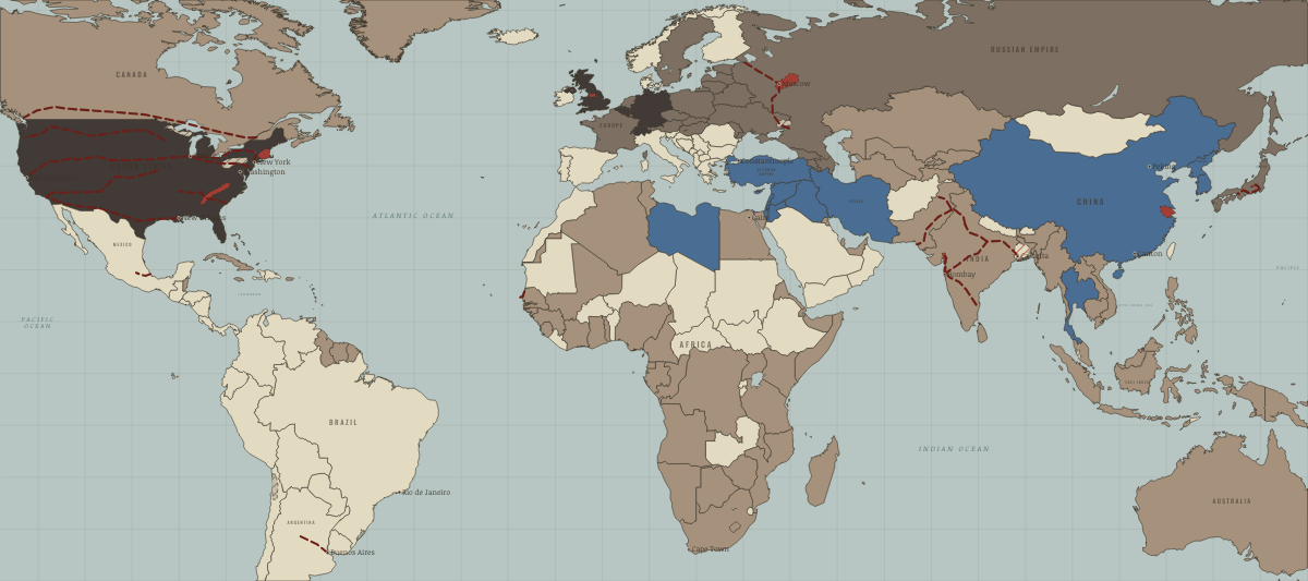
What changes on the map
| The United States (British colonies to 1776) | Industrialising → Industrial economy |
| Belgium (Austrian Netherlands to 1795; independent 1830) | Industrialising → Industrial economy |
| The German states (the German Empire from 1871) | Industrialising → Industrial economy |
| Switzerland | Industrialising → Industrial economy |
| Japan | Opened by force or treaty → Industrialising |
| Korea (Japanese from 1910) | — → Opened by force or treaty |
| Korea — north (Japanese from 1910) | — → Opened by force or treaty |
| The Russian Empire | — → Industrialising |
| Ukraine (Russian and Habsburg empires) | — → Industrialising |
| Belarus (Russian Empire) | — → Industrialising |
| Lithuania (Russian Empire) | — → Industrialising |
| Latvia (Russian Empire) | — → Industrialising |
| Estonia (Russian Empire) | — → Industrialising |
| Moldova | — → Industrialising |
| Azerbaijan | — → Industrialising |
| Georgia | — → Industrialising |
| Armenia | — → Industrialising |
| Hungary (Habsburg Empire) | — → Industrialising |
| Upper Hungary (mod. Slovakia) | — → Industrialising |
| Turkestan (Russian Empire) | — → Colony or dependency |
| Turkmenistan | — → Colony or dependency |
| Kyrgyzstan | — → Colony or dependency |
| Tajikistan | — → Colony or dependency |
| Vietnam (French Indochina from 1887) | — → Colony or dependency |
On the ground
- the cotton mill belt of the Carolina and Georgia Piedmont, growing from the 1880s
- the Donbas coalfield of the Russian Empire
- the Baku oil fields, producing about half the world’s oil around 1900
- the Chikuhō coalfield that fuelled the Yawata steelworks
- the cotton-spinning district of Osaka and Kobe
- the silk-reeling districts of Nagano and Gunma, around Okaya and Tomioka
- the Witwatersrand gold fields, opened in 1886
- the tin fields of the Kinta valley and Selangor
- the nitrate fields of the Atacama, the world’s main source of nitrogen before 1913
The chapters of this moment
Related maps
THE FREE PRINTABLE STUDY GUIDE
Join the Dispatch — a short welcome series, then a letter when a new atlas opens — and the printable study guide for The Industrial Revolution is yours now, free.
NO TRACKING · YOUR ADDRESS IS USED FOR THE DISPATCH AND NOTHING ELSE · UNSUBSCRIBE ANYTIME